Nicht so schwierig
Huaxtla
v3 a3 III
4h15
30min
3h30
15min
25m
2x30 or similar
7
Auto benötigt
Bewertung:
★★★★★
2.5 (1)
Beschreibung:
★★★
2 (1)
Verankerung:
★★★
2 (1)
Charakteristik:
maschinell übersetzt
➜
Originalsprache
River walk and bolder hopping with a few nice rappels in the later part in a not so clean canyon. Recommended to do entrance with the 110m dry rappel to only do the last part.
Riverwalk und Bolder Hopping mit ein paar netten Abseilstellen im späteren Teil in einem nicht ganz so sauberen Canyon
Anfahrt:
maschinell übersetzt
➜
Originalsprache
To do only the (lower) part of the canyon entering on the 110m dry rappel, you go to the right on km18 in direction Huaxtla village and park at the view point (see also GPS)
Another potential "Middle" Entry (not tried yet): We drive to km 20 on „Carretera a Cotolan“ from Zapopan in direction San Cristobal de la Barranca. You park there next to the access road of a hotel (Hacienda Lomajim).
To do the full canyon (which is not recommended as it has additional 1-2h of walking and bolder hopping) von directly enter at km 18 on the same road on the bridge.
You need to shuttle the cars to the parking spot on the exit (see gps coordinates).
Empfohlener Einstieg (noch nicht ausprobiert): Wir fahren bis km 20 auf der "Carretera a Cotolan" von Zapopan in Richtung San Cristobal de la Barranca. Dort parkt man neben der Zufahrt zu einem Hotel (Hacienda Lomajim).
Um den gesamten Canyon zu durchwandern (was nicht zu empfehlen ist, da es zusätzliche 2 Stunden Fußmarsch und Bolder Hopping bedeutet), fahren Sie direkt bei km 18 auf derselben Straße über die Brücke.
Sie müssen die Autos auf dem Parkplatz am Ausgang shuttle (siehe GPS-Koordinaten).
Zustieg (30 min):
maschinell übersetzt
➜
Originalsprache
To do only the (lower) part of the canyon entering on the 110m dry rappel, you walk from the viewpoint parking towards the dry river and then on the dry river bed to the edge of the big drop. On the right hand side you should see bolts for handline and a two bolt anchor.
Potential "Middle" Entry: You park there next to the access road of a hotel (Hacienda Lomajim). There should be a small dam to be seen (not confirmed yet) and you follow down the dam outlet into the canyon. The last part looks like some scrambling to do, see also pictures.
To do the full canyon: enter the canyon directly on the bridge on km 18.
Empfohlener Eingang (noch nicht ausprobiert): Man parkt dort neben der Zufahrtsstraße eines Hotels (Hacienda Lomajim). Dort sollte ein kleiner Staudamm zu sehen sein (noch nicht bestätigt) und man folgt dem Auslauf des Staudamms hinunter in den Canyon. Der letzte Teil sieht nach einer Kletterpartie aus, siehe auch Bilder.
Um den ganzen Canyon zu durchqueren: direkt auf der Brücke bei Kilometer 18 in den Canyon einfahren.
Tour (3 h 30):
maschinell übersetzt
➜
Originalsprache
If you would do the full canyon starting from the bridge you will have additional 1-2h of walking and bolder hopping with smaller pools.
Entering from a potential "middle entry" you will have to do approximately 30 minutes of walking/downclimbing todo until you reach the first bigger potential rappel or jump.
- rappel approx. 10m, bolts on the left
- approx. 20m, bolts on the right
- approx. 15m, bolts on the left
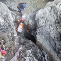
- downclimb or abseil on a single bolt, approx. 15m, bolt left
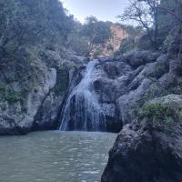
- approx. 20m abseil with handline, easy if you have long legs
Do NOT exit the trip to the right on the path, continue for the next two rappels
- there is another smaller rappel, maybe 15m
- and the final one looks like the biggest one, approx. 25m (not confirmed yet)
Then you do a small walk until you find a water way leaving on the left side of the canyon.
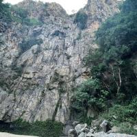
If you do the entrance with the 110m dry rappel from the wall you will get roughly 35m, 30m and 40m rappels in the wall and then hit the canyon skipping the first three rappels but also a lot of bolder hopping, which would be the recommendation.
Wenn man vom empfohlenen Einstieg aus einsteigt, muss man ca. 30 Minuten laufen/abklettern, bis man die erste größere potentielle Abseilstelle oder den Sprung erreicht.
- Abseilen ca. 10m, Bohrhaken auf der linken Seite
- ca. 20m, Bohrhaken auf der rechten Seite
- ca. 15m, Bohrhaken auf der linken Seite
- Abstieg oder Abseilen an einem einzelnen Bohrhaken, ca. 15m, Bohrhaken links
- ca. 20m Abseilen mit Handleine, leicht, wenn man lange Beine hat
NICHT rechts auf dem Weg aussteigen, sondern die nächsten zwei Abseilstellen weitergehen
- es gibt eine weitere kleinere Abseilstelle, vielleicht 15 m
- und die letzte scheint die größte zu sein, ca. 25m (noch nicht bestätigt)
Dann machen Sie einen kleinen Spaziergang, bis Sie einen Wasserweg finden, der auf der linken Seite des Canyons abzweigt.
Rückweg (15 min):
maschinell übersetzt
➜
Originalsprache
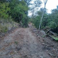
Follow the water way until it reaches the dirt road. Then walk back to the second car.
Folgen Sie dem Wasserweg, bis er den Feldweg erreicht. Gehen Sie dann zurück zum zweiten Auto.
Koordinaten:
Alternativer Canyon Start
20.93371°, -103.429981°
↓↑
DMS: 20° 56" 1.36', -104° 34" 12.07'
DM: 20° 56.023", -104° 34.201"
Google Maps
DMS: 20° 56" 1.36', -104° 34" 12.07'
DM: 20° 56.023", -104° 34.201"
Google Maps
Canyon from top (long river walk plus bolder hopping, not recommended)
Parkplatz Zustieg
20.947441°, -103.415798°
↓↑
DMS: 20° 56" 50.79', -104° 35" 3.13'
DM: 20° 56.846", -104° 35.052"
Google Maps
DMS: 20° 56" 50.79', -104° 35" 3.13'
DM: 20° 56.846", -104° 35.052"
Google Maps
Park next to hotel entrance at KM 20 of the road for recommended entry
Parkplatz Zustieg
20.935399°, -103.429701°
↓↑
DMS: 20° 56" 7.44', -104° 34" 13.08'
DM: 20° 56.124", -104° 34.218"
Google Maps
DMS: 20° 56" 7.44', -104° 34" 13.08'
DM: 20° 56.124", -104° 34.218"
Google Maps
Parking for full canyon
Alternativer Canyon Start
20.941397°, -103.419068°
↓↑
DMS: 20° 56" 29.03', -104° 34" 51.36'
DM: 20° 56.484", -104° 34.856"
Google Maps
DMS: 20° 56" 29.03', -104° 34" 51.36'
DM: 20° 56.484", -104° 34.856"
Google Maps
A potential middle entrance (but not confirmed yet, needs for sure some bush scrambling to get down)
Parkplatz Ausstieg
20.949075°, -103.39476°
↓↑
DMS: 20° 56" 56.67', -104° 36" 18.86'
DM: 20° 56.945", -104° 36.314"
Google Maps
DMS: 20° 56" 56.67', -104° 36" 18.86'
DM: 20° 56.945", -104° 36.314"
Google Maps
Parking return
Canyon Start
20.936879°, -103.40642°
↓↑
DMS: 20° 56" 12.76', -104° 35" 36.89'
DM: 20° 56.213", -104° 35.615"
Google Maps
DMS: 20° 56" 12.76', -104° 35" 36.89'
DM: 20° 56.213", -104° 35.615"
Google Maps
Recommended entrance from the view point down a dry 110m wall
Parkplatz Zustieg
20.936321°, -103.40524°
↓↑
DMS: 20° 56" 10.76', -104° 35" 41.14'
DM: 20° 56.179", -104° 35.686"
Google Maps
DMS: 20° 56" 10.76', -104° 35" 41.14'
DM: 20° 56.179", -104° 35.686"
Google Maps
Parking for recommended entrance from the view point
05.11.2024
Max H.
⭐
★★★★★
📖
★★★
⚓
★★★
💧
Niedrig
Begangen ✔
Auch mit dabei waren: Christian Haas DaRaph
Begehung mit 6 Leuten im Rahmen des RIC 2024. Sind leider von oben eingestiegen da wir keine genauen Informationen hatten wo man am besten in den Bach runter queren kann. Haben den Ausstieg zu früh gewählt und die letzten beiden Abseiler verpasst. Wenn man einen guten Mitteleinstieg findet sicher eine relativ schöne Halbtagestour. Bach war ziemlich dreckig (viel Müll) und das Wasser war nicht klar und auch nicht ganz sauber.
Auch mit dabei waren: Christian Haas DaRaph
Neue Begehung
Bitte kurz und knacking die wichtigsten Infos der letzten Begehung oder wichtige aktuelle Infos zur Schlucht. Ggf. mit Links zu Videos, Fotos, etc.
*
*
*
Esc
Del
Hydrologie:
maschinell übersetzt
➜
Originalsprache
Seems to have have high water during flooding, can be checked from the bridge, can take a lot of water.
Scheint bei Überschwemmungen Hochwasser zu haben, kann von der Brücke aus kontrolliert werden, kann viel Wasser aufnehmen

Walking in the upper part of...
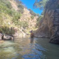
Sometime you have some pools...

Here would be a good entry t...
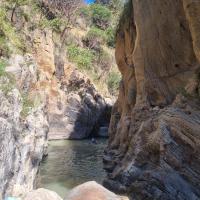
After a while it gets more e...
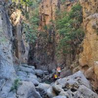
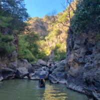
A tricky downclimb where we...


First bolt

First 10m rappel

From below

20m rap

Next approx 15m
Another one where downclimb...

Big waterfall with handline...

Do NOT exit the canyon here

Next waterfall, a smaller on...

Next water fall, a big one

Walk back on water way until...
Gravel road back to car

Car park at Exit

Approach from commercial ent...

Approach from commercial ent...

Approach from commercial ent...

First rep of 110m wall
110m wall from the bottom

Last 2 reps of 110m wall