Etwas schwierig
Kronburger Tobel
v4 a3 V
5h
45min
4h
15min
1130m
800m
330m
25m
2x35m
30
1000m
zu Fuß
Bewertung:
★★★★★
4 (10)
Beschreibung:
★★★
2.3 (7)
Verankerung:
★★★
2 (8)
Charakteristik:
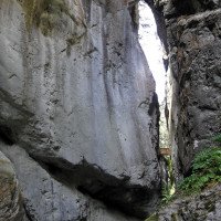
Technical abseilcanyon renowned for its continuity, little to no escape routes, dark atmosphere and impressive floods/mudflows that put the anchors to the test. Before committing one must evaluate current state of the canyon and avoid rain or thunderstorms at all cost.
9-16 Uhr
Nordwest
Dolomit
10.00km²
Charakteristik:
Technical abseilcanyon renowned for its continuity, little to no escape routes, dark atmosphere and impressive floods/mudflows that put the anchors to the test. Before committing one must evaluate current state of the canyon and avoid rain or thunderstorms at all cost.
Anfahrt:
Inntalautobahn A12 bei Schönwies/Mils östlich von Landeck abfahren. Am westlichen Ortsende von Schönwies links von der Bundesstraße in den Ort abbiegen. Kronburg ist angeschrieben. Den Minischildern nach Kronburg folgen (westlich der Bahn entlang und dann in den Wald). nach 5 min führt die Straße über eine Brücke, hier parken.
Zustieg (45 min):
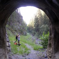
From the P we head to the bridge to check waterlevels and find a small, very straightforward trail on the orographic R with many viewpoints into the canyon and possible intermediate entrances. Your loss if you choose not to do the upper canyon. We continue steep, neglecting the panoramic hiking trail, until we reach a tunnel (road on our left). After the tunnel we continue 100m to easily descend into the river bed, backtracking these 100m to the start of the canyon.
Tour (4 h):
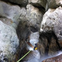
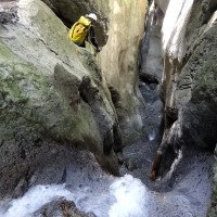
Multiple intermediate entrances exist that are only interesting for commercial tours, described here is the full tour. The entrance abseil originally was from a tree (at the exit of the approach tunnel). Now, an anchor is to be found on a large boulder R. Best not to pull back the rope yet, but check the state of the anchor on the second and highest abseil (+-30m) of the tour (R, two glue-in bolts, damaged since many years). A continuous string of smaller abseils follow, some of which are newer (2022-2024) and well-protected, recommended is to stay in the rope, to access the anchors. The lower canyon is excessively bolted, and often with fixed ropes. Two emergency exits now, one L and another R with fixed rope to ascend and reach the bridge in 5 min.
Rückweg (15 min):
Either exit using the fixed rope R and reach the bridge/parking in 5 min. or continue in the canyon until we reach the Inn valley, return R via a small straightforward trail that cuts through the woods and back to the road.
Koordinaten:
Canyon Start
47.1768°, 10.6442°
↓↑
DMS: 47° 10" 36.48', 10° 38" 39.12'
DM: 47° 10.608", 10° 38.652"
Google Maps
Österreich Topo
DMS: 47° 10" 36.48', 10° 38" 39.12'
DM: 47° 10.608", 10° 38.652"
Google Maps
Österreich Topo
Canyon Ende
47.1827°, 10.6346°
↓↑
DMS: 47° 10" 57.72', 10° 38" 4.56'
DM: 47° 10.962", 10° 38.076"
Google Maps
Österreich Topo
DMS: 47° 10" 57.72', 10° 38" 4.56'
DM: 47° 10.962", 10° 38.076"
Google Maps
Österreich Topo
Alternativer Canyon Start
47.1794°, 10.6399°
↓↑
DMS: 47° 10" 45.84', 10° 38" 23.64'
DM: 47° 10.764", 10° 38.394"
Google Maps
Österreich Topo
DMS: 47° 10" 45.84', 10° 38" 23.64'
DM: 47° 10.764", 10° 38.394"
Google Maps
Österreich Topo
D 2 (1020m) (descente)
Alternativer Canyon Start
47.181°, 10.6365°
↓↑
DMS: 47° 10" 51.6', 10° 38" 11.4'
DM: 47° 10.86", 10° 38.19"
Google Maps
Österreich Topo
DMS: 47° 10" 51.6', 10° 38" 11.4'
DM: 47° 10.86", 10° 38.19"
Google Maps
Österreich Topo
D4 (870m) (descente)
Parkplatz Zustieg und Ausstieg
47.1824°, 10.6366°
↓↑
DMS: 47° 10" 56.64', 10° 38" 11.76'
DM: 47° 10.944", 10° 38.196"
Google Maps
Österreich Topo
DMS: 47° 10" 56.64', 10° 38" 11.76'
DM: 47° 10.944", 10° 38.196"
Google Maps
Österreich Topo
(descente_2)
Literatur:
Karte
Karte
1:50000
Canyoning Buch
Werner Baumgarten
2010
Canyoning Buch
Alexander Riml / Gunnar Amor
2012
Canyoning Buch
Stéphane Coté / Caracal et les Sancho Panza
2008
Canyoning Buch
Werner Baumgarten
2013
Canyoning Booklet
AIC
2024
Booklet des Canyoning Treffens in Südtirol 2024 - Beschreibungen übernommen nach freundlicher Genehmigung
Cwiki Canyon Info
Descente Canyon Info
Ropewiki Canyon Info
Galerie
11.04.2025
Jeroen Kirchner
⭐
★★★★★
📖
★★★
⚓
★★★
💧
Niedrig
Begangen ✔
maschinell übersetzt
➜
Originalsprache
All ingredients are united for a new devastating flood/natural dam to build. To appreciate, one should do the top start (at the tunnel), notice the moving rocks and trees that have been cut and fallen/thrown into the river bed. If these rocks or trees are not there, it is best not to enter unprepared!
Regarding the broken anchor: its location is in the flow, hence impossible to replace in a durable way. Let's try sth new. I've placed an abalakov/Sanduhr with 12mm drill in the most obvious location. When damaged or missing, it should be easier to replace than a broken bolt.
Alle Zutaten sind vereint, um einen neuen, verheerenden Hochwasser-/Naturdamm zu errichten. Um das zu verstehen, sollte man den oberen Start (am Tunnel) machen und die beweglichen Felsen und Bäume beachten, die gefällt und in das Flussbett geworfen wurden. Wenn diese Felsen oder Bäume nicht vorhanden sind, sollte man nicht unvorbereitet einsteigen!
Was den zerbrochenen Anker betrifft: Er liegt in der Strömung und kann daher nicht dauerhaft ersetzt werden. Versuchen wir etwas Neues. Ich habe einen Abalakov/Sanduhr mit 12-mm-Bohrer an der offensichtlichsten Stelle angebracht. Wenn er beschädigt ist oder fehlt, sollte er leichter zu ersetzen sein als ein gebrochener Bolzen.
06.04.2025
Gregor Bernsteiner
⭐
★★★★★
📖
★★★
⚓
★★★
💧
Niedrig
Begangen ✔
vom Einstieg Stand 35 - Stand 08 (Führer Riml/Amor) begangen.
Wenige Bohrhacken beschädigt.
!!!!Achtung 1 Bohrhacken gebrochen!!!!
Aber trotzdem noch gut begehbar.
Für eine Stunde ist der Wasserstand deutlich gestiegen!!
18.10.2024
Jeroen Kirchner
⭐
★★★★★
📖
★★★
⚓
★★★
💧
Normal
Begangen ✔
maschinell übersetzt
➜
Originalsprache
Water levels are stable, some pools are clean of gravel. Did another effort to remove damaged anchors, in total since i started with this +-40 anchors.
Warning: 1 glue-in with ring (right bank, half-way the canyon) is broken, but still may be of use since this passage is practically downclimbable without aid.
3 hours for the full canyon in 3 persons.
Wasserstände sind stabil, einige Becken sind sauber von Kies. Hat eine weitere Anstrengung, um beschädigte Anker zu entfernen, insgesamt seit ich begann mit diesem +-40 Anker.
Achtung: 1 Klebeanker mit Ring (rechtes Ufer, auf halber Strecke der Schlucht) ist gebrochen, kann aber immer noch von Nutzen sein, da diese Passage praktisch ohne Hilfe abwärts kletterbar ist.
3 Stunden für die gesamte Schlucht mit 3 Personen.
11.10.2024
Manuel Reindl
⭐
★★★★★
📖
★★★
⚓
★★★
💧
Niedrig
Begangen ✔
Auch mit dabei waren: Paul Mistlbacher
Wasserstand sehr niedrig. Stände ok. Oberen und mittleren Teil begangen.
Auch mit dabei waren: Paul Mistlbacher
06.09.2024
Jeroen Kirchner
⭐
★★★★★
📖
★★★
⚓
★★★
💧
Normal
Begangen ✔
maschinell übersetzt
➜
Originalsprache
Removed many of the fixed ropes before the heavy rains that are forecasted. Noticed a couple of new trees and (not stainless & some unnecessary) steel anchors.
Entfernt viele der festen Seile vor den schweren Regenfällen, die vorhergesagt werden. Bemerkte ein paar neue Bäume und (nicht rostfrei & einige unnötige) Stahlanker.
14.06.2024
Max Rudholzer
⭐
★★★★★
📖
★★★
⚓
★★★
💧
Normal
Begangen ✔
Derzeit ist von einer Begehung der Kronburg dringend abzuraten. Es gibt ungeklärte Probleme mit dem Kraftwerkbetreiber oberhalb der Schlucht.
Diese Saison mussten bereits 2 Gruppen an unterschiedlichen Tagen wegen plötzlich ansteigenden Wasserpegels aus der Schlucht ausgeflogen werden.
04.05.2024
Yorickvn
⭐
★★★★★
📖
★★★
⚓
★★★
💧
Normal
Begangen ✔
Automatisch importiert von Descente-Canyon.com für Canyon Kronburger Schlucht
We started at the second entry, just before the footbridge. Very deep and narrow canyon. Lots of fun, smaller rappels quickly after one another, very little walking in between. The state of the anchors differs a lot between rappels. Some newer monopoints, some some new chains on older (but ok) bolt, some new bolts with old rusty chains, some old anchors that should be replaced. A lot of old hardware still in the walls. Canyon could use a good clean up. Relaxed descent in about 2.5h, can probably also be done in 1.5h. Very nice flow, enough to get a little wet, but nothing dangerous. This second part, with this flow, much easier than v5a5. Path next to canyon blocked by trees, accessible but probably easier to take the longer official path. Escape not found.
(Quelle: https://www.descente-canyon.com/canyoning/canyon-debit/22070/observations.html)
06.10.2023
Gregor Bernsteiner
⭐
★★★★★
📖
★★★
⚓
★★★
💧
Begangen ✔
Bohrhaken, Ketten und Fixseile beschädigt. (Unwetter)
09.03.2023
System User
⭐
★★★★★
📖
★★★
⚓
★★★
Info: Teile der Canyonbeschreibung wurden automatisiert übernommen. Konkret die Felder Weblinks, Koordinaten, Rating, Länge des Canyon, Einfachseil Mindestens von https://www.descente-canyon.com/canyoning/canyon/22070
09.03.2023
System User
⭐
★★★★★
📖
★★★
⚓
★★★
Daten importiert von https://canyon.carto.net/cwiki/bin/view/Canyons/BananaCanyon.html
Neue Begehung
Bitte kurz und knacking die wichtigsten Infos der letzten Begehung oder wichtige aktuelle Infos zur Schlucht. Ggf. mit Links zu Videos, Fotos, etc.
*
*
*
Esc
Del
Hydrologie:
Water capture above, and release in the canyon halfway. Devastating floods with mud and other debris such as trees, most likely caused by the rupture of natural dams in/above the canyon.


