a little difficult
Leyvra
Country:
Schweiz / Switzerland
Region: Kanton Waadt / Canton de Vaud
Subregion: Ancien district du Pays-d'Enhaut
Town: Chateau d'Oex
v4 a3 III
3h20
15min
2h45
20min
1460m
1270m
190m
40m
2x 40m
16
250m
Rating:
★★★★★
3.1 (3)
Info:
★★★
3 (1)
Belay:
★★★
3 (1)
Summary:
machine translated
➜
Original language
Alpiner Canyon, südseitig ausgerichtet, wenig eingeschnitten, Abfolge von Wasserfällen ohne Laufstrecken, keine Sprungmöglichkeit, selten eine Möglichkeit zum Rutschen, kurz, angenehmer Zustieg
Alpine canyon, south-facing, little cut, sequence of waterfalls without runs, no possible jumps, rarely a possibility for slides, short, pleasant access
April - November
South
Limestone
0.80km²
Summary:
machine translated
➜
Original language
Alpiner Canyon, südseitig ausgerichtet, wenig eingeschnitten, Abfolge von Wasserfällen ohne Laufstrecken, keine Sprungmöglichkeit, selten eine Möglichkeit zum Rutschen, kurz, angenehmer Zustieg
Alpine canyon, south-facing, little cut, sequence of waterfalls without runs, no possible jumps, rarely a possibility for slides, short, pleasant access
Access:
machine translated
➜
Original language
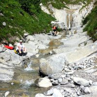
Von Chateau d'Oex im Saane-Tal (975m üNN) nehmen wir die Route du Mont,\nhalten uns bei den letzten Häusern rechts. Vorbei an den Häusern von Le Mont (1097m üNN) geht es hinauf zum Weiler Les Planches (Bauernhof rechts oberhalb der Straße, 1300m üNN), den man erreicht, nachdem man wenige Meter vorher einen kleinen Bach überquert hat. 260m weiter nehmen wir nicht die Haarnadelkurve nach rechts, sondern halten geradeaus, um dann nach weiteren 190m - wieder rechts oberhalb der Straße ein Gehöft - unser Auto in der Rechtskurve auf der Freifläche links der Straße abzustellen. Von hier kann man den Leyvra schon shr gut einsehen.
From Chateau d'Oex in the Saane Valley (975m a.s.l.) we take the Route du Mont,\nhalten at the last houses on the right. Passing the houses of Le Mont (1097m a.s.l.), we go up to the hamlet of Les Planches (farm on the right above the road, 1300m a.s.l.), which we reach after crossing a small stream a few meters before. 260m further on, we do not take the hairpin bend to the right, but keep straight on, and then after another 190m - again a farmstead on the right above the road - we park our car in the right-hand bend on the open space to the left of the road. From here you can see the Leyvra already shr well.
Approach (15 min):
machine translated
➜
Original language
Wir folgen der Straße 300m weiter leicht bergauf und kommen zu dem Gehöft L'Eterpaz, 1368m üNN. Hier endet die Straße. Von hier folgen wir dem unscheinbaren Pfad über die Wiese leicht aufwärts in den Wald. Wir passieren eine Holzhütte ("Au Pralez, alt. 1443m") und erreichen wenige Minuten später das Bachbett. Wie auch beim benachbarten Tenasses kann man an der orograf. rechten Hangseite noch ansteigen, um etwas höher im Bach den Abstieg zu beginnen.
We follow the road slightly uphill for 300m and we arrive at the farmstead L'Eterpaz, 1368m above sea level. Here the road ends. From here we follow the inconspicuous path across the meadow slightly uphill into the forest. We pass a wooden hut ("Au Pralez, alt. 1443m") and a few minutes later we reach the streambed. As with the neighboring Tenasses, you can still climb on the orographic. right side of the slope to start the descent a little higher in the stream.
Tour (2 h 45):
machine translated
➜
Original language
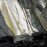
Abstieg in meist offenem Bachbett auf griffigem und meist glatt geschliffenem Kalkstein in kleinräumigen Absätzen. Praktisch keine Laufstrecken.
Descent in mostly open streambed on grippy and mostly smoothly polished limestone in small-scale ledges. Practically no running trails.
Return (20 min):
machine translated
➜
Original language
Wo der Bach verflacht (1270m üNN), steigen wir auf undeutlichen Spuren links hinaus und gehen weglos über die Wiesen hinauf zum Parkplatz.
Where the stream flattens out (1270m a.s.l.), we climb out on indistinct tracks to the left and walk trail-less across the meadows up to the parking lot.
Coordinates:
Canyon Start
46.4944°, 7.13626°
↓↑
DMS: 46° 29" 39.84', 7° 8" 10.54'
DM: 46° 29.664", 7° 8.176"
Google Maps
SwissTopo
DMS: 46° 29" 39.84', 7° 8" 10.54'
DM: 46° 29.664", 7° 8.176"
Google Maps
SwissTopo
Canyon End
46.4921°, 7.1385°
↓↑
DMS: 46° 29" 31.56', 7° 8" 18.6'
DM: 46° 29.526", 7° 8.31"
Google Maps
SwissTopo
DMS: 46° 29" 31.56', 7° 8" 18.6'
DM: 46° 29.526", 7° 8.31"
Google Maps
SwissTopo
Parking Entry and Exit
46.49091°, 7.14372°
↓↑
DMS: 46° 29" 27.28', 7° 8" 37.39'
DM: 46° 29.455", 7° 8.623"
Google Maps
SwissTopo
DMS: 46° 29" 27.28', 7° 8" 37.39'
DM: 46° 29.455", 7° 8.623"
Google Maps
SwissTopo
Literatures:
Map
1:25000
Canyoning Book
Emmanuel Belut / Laurence Boyé / Thomas Guigon
Association Openbach
2015
9782746679450
Canyoning Book
Emmanuel Belut / Laurence Boyé / Thomas Guigon
Association Openbach
2015
9782746679450
Cwiki Canyon Info
Descente Canyon Info
Ropewiki Canyon Info
Gallery
29.09.2024
Sacha
⭐
★★★★★
📖
★★★
⚓
★★★
💧
Normal
Completed ✔
no translation available
Automatisch importiert von Descente-Canyon.com für Canyon Leyvra
RAS.
(Quelle: https://www.descente-canyon.com/canyoning/canyon-debit/22255/observations.html)
14.07.2024
Alex
⭐
★★★★★
📖
★★★
⚓
★★★
💧
Low
Completed ✔
machine translated
➜
Original language
Herrlich vertikal! Gut auch mit Anfängern machbar.
Wonderfully vertical! Also suitable for beginners.
14.07.2024
Alexxx
⭐
★★★★★
📖
★★★
⚓
★★★
💧
Low
Completed ✔
no translation available
Automatisch importiert von Descente-Canyon.com für Canyon Leyvra
Toutes les installations sont ok. Sinon, RAS.
(Quelle: https://www.descente-canyon.com/canyoning/canyon-debit/22255/observations.html)
08.07.2024
NicoSimon
⭐
★★★★★
📖
★★★
⚓
★★★
💧
Low
Completed ✔
no translation available
Automatisch importiert von Descente-Canyon.com für Canyon Leyvra
DC-, encore ok mais il faudrait pas moins d'eau pour que ça reste sympa...
(Quelle: https://www.descente-canyon.com/canyoning/canyon-debit/22255/observations.html)
08.06.2024
Gautama108
⭐
★★★★★
📖
★★★
⚓
★★★
💧
Normal
Completed ✔
no translation available
Automatisch importiert von Descente-Canyon.com für Canyon Leyvra
RAS. Enchainé avec Mérils.
(Quelle: https://www.descente-canyon.com/canyoning/canyon-debit/22255/observations.html)
07.06.2024
Taffon
⭐
★★★★★
📖
★★★
⚓
★★★
💧
Normal
Completed ✔
no translation available
Automatisch importiert von Descente-Canyon.com für Canyon Leyvra
Tous les ancrage ont bien passé l'hiver.
(Quelle: https://www.descente-canyon.com/canyoning/canyon-debit/22255/observations.html)
18.02.2024
tom2bdx
⭐
★★★★★
📖
★★★
⚓
★★★
💧
Normal
Completed ✔
no translation available
Automatisch importiert von Descente-Canyon.com für Canyon Leyvra
Pas de nevé dans le canyon. DC, amarrages Ok.
(Quelle: https://www.descente-canyon.com/canyoning/canyon-debit/22255/observations.html)
20.10.2023
NicoSimon
⭐
★★★★★
📖
★★★
⚓
★★★
💧
Normal
Completed ✔
no translation available
Automatisch importiert von Descente-Canyon.com für Canyon Leyvra
DC, équipement RAS, moins sympa que Tenasses à mon goût mais sympa quand-même pour occuper un jour de pluie :-)
(Quelle: https://www.descente-canyon.com/canyoning/canyon-debit/22255/observations.html)
09.03.2023
System User
⭐
★★★★★
📖
★★★
⚓
★★★
no translation available
Info: Teile der Canyonbeschreibung wurden automatisiert übernommen. Konkret die Felder Weblinks, Koordinaten, Rating, Länge des Canyon, Einfachseil Mindestens von https://www.descente-canyon.com/canyoning/canyon/22255
09.03.2023
System User
⭐
★★★★★
📖
★★★
⚓
★★★
no translation available
Daten importiert von https://canyon.carto.net/cwiki/bin/view/Canyons/LeyvraCanyon.html
New Report
Please briefly and concisely the most important information of the last tour or important current information about the canyon. If necessary with links to videos, photos, etc..
*
*
*
Esc
Del
Hydrology: