Country:
Deutschland / Germany
Region: Oberbayern / Upper Bavaria
Subregion: Landkreis Berchtesgadener Land
Town: Schellenberger Forst
v2 a2 II
3h
40min
2h15
5min
700m
470m
230m
10m
1x30m
7
2150m
on Foot
Rating:
★★★★★
0 ()
Info:
★★★
0 ()
Belay:
★★★
0 ()
Summary:
machine translated
➜
Original language
"Zubringer" zum unt. Rotmannbach, östlich parallel zum Kargraben, aber von geringerer Attraktivutät. Einige kleinere Abseiler, viel Abklettern.
"Feeder" to the lower Rotmannbach. Rotmannbach, parallel to the Kargraben to the east, but less attractive. Some smaller rappels, lots of downclimbing.
11-15 o clock
Southeast
Summary:
machine translated
➜
Original language
"Zubringer" zum unt. Rotmannbach, östlich parallel zum Kargraben, aber von geringerer Attraktivutät. Einige kleinere Abseiler, viel Abklettern.
"Feeder" to the lower Rotmannbach. Rotmannbach, parallel to the Kargraben to the east, but less attractive. Some smaller rappels, lots of downclimbing.
Access:
machine translated
➜
Original language
Wir nehmen auf der A10 (Tauernautobahn) die Ausfahrt Grödig (südwestlich von Salzburg) und fahren in südwestlicher Richtung zunächst auf der österreichischen B 160 (Berchtesgadenerstraße), nach der deutsch-österr. Grenze weiter auf den auf der B 305 (immer noch Berchtesgadenerstraße bzw "Deutsche Alpenstraße") 4 km in Richtung Marktschellenberg. Dann sehen wir links zwischen B 305 und Berchtesgadener Ache einen langestreckten (Wander-) Parkplatz. Hier stellen wir unser Auto ab.
We take the exit Grödig (southwest of Salzburg) on the A10 (Tauernautobahn) and drive southwest first on the Austrian B 160 (Berchtesgadenerstraße), after the German-Austrian border continue on the B 305 (still Berchtesgadenerstraße or "Deutsche Alpenstraße") for 4 km in the direction of Marktschellenberg. Then we see a long (hiking) parking lot on the left between the B 305 and the Berchtesgadener Ache. We park our car here.
Approach (40 min):
machine translated
➜
Original language
Vom südlichen Ende des Parkplatzes gehen wir auf der B 305 südwärts und nach wenigen Metern das Strässchen vor dem Passturm rechts hinauf. Wir folgen dann der Forststraße, zuerst in westlicher, dann in südwestlicher Richtung durch den Wald über dem Rothmannbach. Bei einer weiß-roten Schranke halten wir uns links., nehmen später eine Abkürzung, die uns li. hinauf wieder auf den Forstweg führt. Nach gut 30 Min. ab B 305 wendet sich die Piste nach Nordwesten. Sie verläuft jetzt auf der orograf. li. Seite des Bachgrabens. Wenn sich eine passende Gelegeheit ergibt, steigen wir nun li. hinunter zum Bachgraben, spätestens af 700m üNN, wo links ein Weg über den Bach abzweigt
From the southern exit of the parking lot, head south on the B 305 and after a few meters take the small road on the right before the pass tower. We then follow the forest road, first west and then southwest through the forest above the Rothmannbach stream. We keep left at a white and red barrier and later take a shortcut that leads us back up to the forest road on the left. After a good 30 minutes from the B 305, the track turns to the northwest. It now runs on the orographic left side of the stream ditch. If there is a suitable opportunity, we now descend to the left down to the stream ditch, at the latest at 700m above sea level, where a path branches off to the left over the stream
Tour (2 h 15):
machine translated
➜
Original language
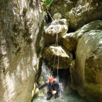
Beim Zustieg über den Bachgraben steht zu Beginn - bis zur Mündung in den Rothmannbach - viel Blockkletterei mit einigen wenigen kleineren Abseilern (3).
Die Tour wird fortgesetzt im unteren Rothmannbach; siehe insoweit dortige Beschreibung. Hier ist zu Beginn die Rede von "einem Zu- Fluss von li ". Das ist der Bachgraben. Zeitbedarf: ca. 45 Min. im Bachgaben + ca. 90 Min. im unt. Rothmannbach. Strecke: 650m im Bachgraben + 1500m im unt. Rothmannbach.
At the beginning of the access via the Bachgraben - up to the mouth of the Rothmannbach - there is a lot of block climbing with a few smaller rappels (3).
The tour continues in the lower Rothmannbach; see the description there. At the beginning there is talk of "an inflow from left". This is the Bachgraben. Time required: approx. 45 min. in the Bachgaben + approx. 90 min. in the lower Rothmannbach. Rothmannbach. Distance: 650m in the Bachgraben + 1500m in the unt. Rothmannbach.
Return (5 min):
machine translated
➜
Original language
Entweder vor der ersten Brücke li. hinaus und auf der B 305 zum Auto oder besser unter der B 305 hindurch und in der Berchtesgadener Ache hinabschwimmen bis zum Parkplatz. ( ca. 10 Min )
Either go left before the first bridge and follow the B 305 to the car or better under the B 305 and swim down the Berchtesgadener Ache to the parking lot. ( approx. 10 min )
Coordinates:
Canyon Start
Zustiegsweg kreuzt Bachgraben
Canyon End
Mündung Rothmannbach in Berchtesgadener Ache
Parking Entry and Exit
Literatures:
Map
https://geoportal.bayern.de/bayernatlas/
Interaktive Karte Bayerns
Ropewiki Canyon Info
Cwiki Canyon Info
Hydrology:


