a little difficult
Rimonta
v4 a3 III
3h55
15min
3h20
20min
600m
340m
260m
60m
3
4600m
Rating:
★★★★★
3 (1)
Info:
★★★
3 (1)
Belay:
★★★
2 (1)
Summary:
machine translated
➜
Original language
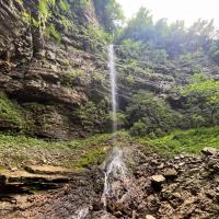
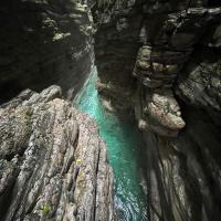
Kurzer vertikaler Abschnitt zwischen langen Strecken des Laufens und Abkletterns. Einige Rutsch- und Sprungmöglichkeiten. Schichtkalk wie beim Val Maor di Mel.
Short vertical part between long stretches of walking and climbing down. Some slides and possible jumps. Stratified limestone as in the Val Maor di Mel.
Access:
machine translated
➜
Original language
Von Belluno auf der SP1 über Limana und Trichana nach Mel, noch 1,8 km weiter auf der SP1 (17,3 km von Belluno bis zur Abzweigung am Kreisverkehr), dann links hinauf nach Villa di Villa ( 360m Höhe). Weiter auf der Straße aufwärts bis zur Brücke über den nächsten Bach, den aus dem Val d'Arc. Hier stellen wir das Auto für den Ausstieg ab (5,4 km ab Kreisverkehr auf der SP1 - 380 m Höhe).\n\nMit dem zweiten geht es weiter bergauf. Schließlich erreichen wir eine große Wiese auf 650m Höhe und stellen hier unser zweites Auto ab (5,5 km von P2 nach P1).
From Belluno on the SP1 via Limana and Trichana to Mel, continue on the SP1 for another 1.8 km (17.3 km from Belluno to the junction at the traffic circle), then turn left up to Villa di Villa ( 360m altitude). Continue up the road until the bridge over the next stream, the one from Val d'Arc. Here we park the car for the exit (5.4 km from the traffic circle on the SP1 - 380 m altitude).\n\nWith the second we continue uphill. Finally we reach a large meadow at 650m altitude and park our second car here (5.5 km from P2 to P1).
Approach (15 min):
machine translated
➜
Original language
Vom Parkplatz den Weg hinunter zum Bach (600m Höhe).
From the parking lot down the path to the stream (600m altitude).
Tour (3 h 20):
machine translated
➜
Original language
Nach einem längeren Anlauf im Bach der vertikale Abschnitt mit einer C30, gefolgt von einer C60. Danach die Möglichkeit eines Ausstiegs nach rechts hinauf zur Straße. Weiter geht es abwechslungsreich gut 1,5 Std. bis zum letzten (6m) Abseiler. Wo dann von rechts der Bach aus dem Val d'Arc zufließt, ist der Abstieg zu Ende.\n
After a long run-up in the stream, the vertical part with a C30, followed by a C60. Then the possibility of an exit to the right up to the road. The route continues in a varied manner for a good 1.5 hours until the last (6m) rappel. Where then from the right the stream from the Val d'Arc flows in, the exit is over.\n
Return (20 min):
machine translated
➜
Original language
Im Bachbett des Val d'Arc aufwärts bis zur Brücke und der Straße.
In the streambed of the Val d'Arc up to the bridge and the road.
Coordinates:
Canyon Start
Parking Entry and Exit
Canyon End
Literatures:
Map
1:25000
Map
1:25000
Map
1/25000
Cwiki Canyon Info
Descente Canyon Info
07.07.2024
MirkoT
⭐
★★★★★
📖
★★★
⚓
★★★
💧
High
Completed ✔
no translation available
Automatisch importiert von Descente-Canyon.com für Canyon Rimonta
Subito dopo confluenza con la val d\'Arc sulla dx c'è un comodo sentiero che porta alla strada dove dopo 100 metri su una curva verso dx si possono lasciare comodamente le auto a valle. Per ingresso a monte è meglio parcheggiare auto a sinistra (lato opposto del grande prato) e tornare indietro a piedi fino a trovare alla propria sx una traccia battuta che scende nel greto. Dal greto ad inizio forra altri dieci minuti.
(Quelle: https://www.descente-canyon.com/canyoning/canyon-debit/23787/observations.html)
24.06.2024
Rok
⭐
★★★★★
📖
★★★
⚓
★★★
💧
Low
Completed ✔
machine translated
➜
Original language
Other users were: Pavel Urbanek
Stände bis auf den letzten 5 m Abseiler tip top (sind ja nur 3 Abseiler insgesamt). Der 5 m Abseiler ist mit 2 Normalhaken, die mit einem Seil verbunden sind, etwas fraglich, aber ok. Kein Vergleich zum Maor, aber trotzdem schön. Laufen im Bachbett, muss man mögen. Sehr einsames Ambiente.
Stands tip top except for the last 5 m rappel (there are only 3 rappels in total). The 5 m rappel is a bit dubious with 2 normal pitons connected with a rope, but ok. No comparison to the Maor, but still nice. You have to like walking in the streambed. Very lonely ambience.
Other users were: Pavel Urbanek
14.04.2024
MirkoT
⭐
★★★★★
📖
★★★
⚓
★★★
💧
Normal
Completed ✔
no translation available
Automatisch importiert von Descente-Canyon.com für Canyon Rimonta
Armi ok, anche se sarebbe meglio cambiare qualche cordino e qualche placchetta+catena.Il punto di ingresso segnato in questo sito è errato (si cammina inutilmente nel greto per 25 minuti) perché rispetto al park si deve tornare indietro ad inizio del prato e da lì cercare un sentiero/traccia che conduce nel greto a 575mslm e dopo una curva a dx del torrente si sbatte sul primo inforramento con tre tuffi consecutivi, calata sui 20 metri e poi La Pisota.Altri due inforramenti (più lunghi ed orizzontali del primo), uno a 500mslm ed un altro a circa 420mslm.Prima di arrivare ad una briglia c'è un sentiero ripido in riva dx che porta ad una strada sterrata che finisce in un tornante su strada asfaltata a quota 380mslm. In questo punto si può usare come park a valle per poi fare navetta di 5,2km.
(Quelle: https://www.descente-canyon.com/canyoning/canyon-debit/23787/observations.html)
25.02.2024
MirkoT
⭐
★★★★★
📖
★★★
⚓
★★★
🌊
Crazy
Completed ✕
no translation available
Automatisch importiert von Descente-Canyon.com für Canyon Rimonta
Nei due giorni precedenti sono scesi circa 70mm di pioggia e quindi nel torrente c'era troppa acqua. Nessuna presenza di neve, ma solo di acqua, anche nei sentieri di avvicinamento.
(Quelle: https://www.descente-canyon.com/canyoning/canyon-debit/23787/observations.html)
09.03.2023
System User
⭐
★★★★★
📖
★★★
⚓
★★★
no translation available
Info: Teile der Canyonbeschreibung wurden automatisiert übernommen. Konkret die Felder Weblinks, Koordinaten, Rating, Länge des Canyon, Einfachseil Mindestens von https://www.descente-canyon.com/canyoning/canyon/23787
09.03.2023
System User
⭐
★★★★★
📖
★★★
⚓
★★★
no translation available
Daten importiert von https://canyon.carto.net/cwiki/bin/view/Canyons/RimontaCanyon.html
New Report
Please briefly and concisely the most important information of the last tour or important current information about the canyon. If necessary with links to videos, photos, etc..
*
*
*
Esc
Del
Hydrology:


