a little difficult
San Joaquin
Country:
España / Spain
Region: Canarias / Canary Islands
Subregion: Santa Cruz de Tenerife
Town: Fasnia
v4 a1 III
2h20
10min
2h
10min
335m
20m
315m
40m
3x30m
8
2600m
Car required
Rating:
★★★★★
1.9 (2)
Info:
★★★
0 ()
Belay:
★★★
0 ()
Summary:
machine translated
➜
Original language
Normalerweise trockener Wandercanyon mit einigen Abseilern.
Normally dry hiking canyon with some rappel.
Summary:
machine translated
➜
Original language
Normalerweise trockener Wandercanyon mit einigen Abseilern.
Normally dry hiking canyon with some rappel.
Access:
machine translated
➜
Original language
Vom Airport Tenerife Sur bei Ausfahrt Nr. 23 auf die Autobahn TF1 und auf dieser in Richtung Sta. Cruz de Tenerife (nordostwärts). Nach 26,5 km auf der TF1 bei Ausfahrt Nr. 14 (Los Roques/Fasnia) abgehen (in San Roques am Meer das erste Fahrzeug abstellen, sofern man zwei zur Verfügung hat.Mit dem anderen - auf der TF 620 - 6 km bergauf nach Fasnia. Im Ort auf die querende TF 28 links abbiegen, in südwestlicher Richtung aus dem Ort, nach etwa 300 kommt man auf der Puente de los Tres Ojos; über den Barranco San Joaquin (hier irreführend andere Bezeichnung) und biegt nach weiteren 50 m links hinab zu der Ruine der Kirche San Joaquin. An dieser links vorbei und etwa 30 m weiter links abbiegen. Nach weiteren 30 m (nach Ende des Straßeneinschnitts) Auto rechts abstellen.
From Tenerife Sur Airport, take exit 23 to the TF1 highway and follow it in the direction of Sta. Cruz de Tenerife (northeast). After 26.5 km on the TF1, take exit no. 14 (Los Roques/Fasnia) (park the first vehicle in San Roques by the sea, if you have two available. With the other one - on the TF 620 - 6 km uphill to Fasnia. In the village turn left on the crossing TF 28, in southwestern direction out of the village, after about 300 one comes on the Puente de los Tres Ojos; over the Barranco San Joaquin (here misleadingly other designation) and turns after another 50 m left down to the ruin of the church San Joaquin. Pass it on the left and turn left about 30 m further on. After another 30 m (after the exit of the road) park the car on the right.
Approach (10 min):
machine translated
➜
Original language
Vom Auto den terrassierten Abhang in nördlicher Richtung hinunter zu dem deutlich sichtbaren ersten Abseiler im Barranco.
From the car down the terraced slope in a northerly direction to the clearly visible first rappel in the barranco.
Tour (2 h):
machine translated
➜
Original language
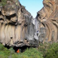
Attraktiv die Basalt-Rose, über die man abseilt (2. Abseiler). Der 40m-Abseiler kann auf einem bequemen Zwischenstand nach etwa 20m gebrochen werden.
Attractive the basalt rose over which you rappel (2nd rappel). The 40m rappel can be broken on a comfortable intermediate stand.
Return (10 min):
machine translated
➜
Original language
Nachdem man im Barranco unter der Autobahn hindurch ist, links auf Pfadspuren bzw. Piste leicht bergan zu dem großen geteerten Platz südlich von Los Roques, wo das untere Fahrzeug steht.
After passing under the highway in the barranco, left on trail tracks or dirt road slightly uphill to the large paved plaza south of Los Roques where the lower vehicle is parked.
Coordinates:
Canyon Start
28.2276°, -16.4392°
↓↑
DMS: 28° 13" 39.36', -17° 33" 38.88'
DM: 28° 13.656", -17° 33.648"
Google Maps
DMS: 28° 13" 39.36', -17° 33" 38.88'
DM: 28° 13.656", -17° 33.648"
Google Maps
Canyon End
Parking at Entry
28.2274°, -16.4394°
↓↑
DMS: 28° 13" 38.64', -17° 33" 38.16'
DM: 28° 13.644", -17° 33.636"
Google Maps
DMS: 28° 13" 38.64', -17° 33" 38.16'
DM: 28° 13.644", -17° 33.636"
Google Maps
Parking at Exit
28.2196°, -16.4147°
↓↑
DMS: 28° 13" 10.56', -17° 35" 7.08'
DM: 28° 13.176", -17° 35.118"
Google Maps
DMS: 28° 13" 10.56', -17° 35" 7.08'
DM: 28° 13.176", -17° 35.118"
Google Maps
Literatures:
Map
Kompass Teneriffa; 1 : 50 000
Map
IGN MTN50 1092 Puerto de la Cruz 1:50.000
Map
http://www.wikiloc.com/wikiloc/view.do?id=3777039
Canyoning Book
35 Descentes de canyon a Tenerife
Philip Van Den Berge
2016
Cwiki Canyon Info
Descente Canyon Info
Ropewiki Canyon Info
Gallery
Trip Report (e.g. Blogpost)
Trip Report (e.g. Blogpost)
Trip Report (e.g. Blogpost)
Trip Report (e.g. Blogpost)
09.03.2023
System User
⭐
★★★★★
📖
★★★
⚓
★★★
no translation available
Info: Teile der Canyonbeschreibung wurden automatisiert übernommen. Konkret die Felder Weblinks, Koordinaten, Rating, Länge des Canyon, Einfachseil Mindestens von https://www.descente-canyon.com/canyoning/canyon/22123
09.03.2023
System User
⭐
★★★★★
📖
★★★
⚓
★★★
no translation available
Daten importiert von https://canyon.carto.net/cwiki/bin/view/Canyons/SanJoaquinCanyon.html
Hydrology:


