v3 a4 V
5h30
2h
2h30
1h
1575m
1130m
445m
18m
2x20m
1650m
Bike/Mountainbike
Rating:
★★★★★
4 (8)
Info:
★★★
2.8 (4)
Belay:
★★★
2 (6)
Summary:
machine translated
➜
Original language
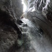
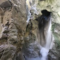
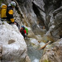
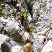
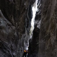
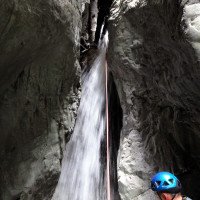
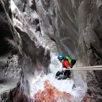
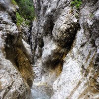
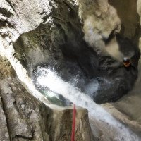
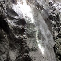
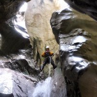
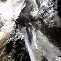
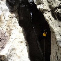
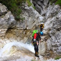
Abfolge vieler kleinerer Abseiler in einer kontinuierlich engen und langen Klammstrecke
Sequence of many smaller rappels in a continuously narrow and long gorge section
South
Summary:
machine translated
➜
Original language
Abfolge vieler kleinerer Abseiler in einer kontinuierlich engen und langen Klammstrecke
Sequence of many smaller rappels in a continuously narrow and long gorge section
Access:
machine translated
➜
Original language
Wir verlassen, von Innsbruck kommend, die A 12 bei Zirl auf die B 177 in Richtung Seefeld, Garmisch (D). Nach etwa 2 km verlassen wir die B 177 über die Ausfahrt Zirl-West. In diesem Bereich beginnt die Hochzirler Straße, der wir bergauf folgen. Nach 1,7 km mündet von rechts eine Forststraße ein. Hier können wir an geeigneter Stelle das untere Auto abstellen. Mit dem zweiten geht es weiter bergauf, vorbei am Bahnhof Hochzirl bis zum Landeskrankenhaus Hochzirl (3 km ab B 177). Hier das (obere) Auto am linken Straßenrand abstellen.
Coming from Innsbruck, we leave the A 12 at Zirl onto the B 177 in the direction of Seefeld, Garmisch (D). After about 2 km we leave the B 177 via the Zirl-West exit. This is where the Hochzirler Straße begins, which we follow uphill. After 1.7 km, a forest road joins from the right. Here we can park the lower car in a suitable place. The second car continues uphill, past the Hochzirl train station to the Hochzirl regional hospital (3 km from the B 177). Park the (upper) car on the left-hand side of the road here.
Approach (2 h):
machine translated
➜
Original language
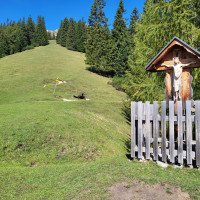
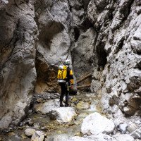
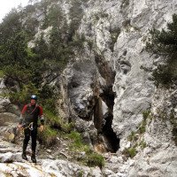
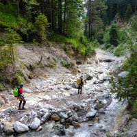
Vom oberen Parkplatz nehmen wir den Waldweg, der direkt oberhalb des Krankenhauses entlang in östlicher Richtung führt. Hier und in der Folge orientieren wir uns an der Wegweisung "Solsteinhaus". Falls man nur ein Auto zur Verfügung hat, stellt man es zweckmäßigerweise auf den unteren Parkplatz, läuft dann den hier endenden Waldweg aufwärts. Schon nach 300 m eröffnet sich hier die erste Möglichkeit, zum oberen Zustiegsweg hinauf zu wechseln ("Brunnalm"). Nach 2 km (ab Hochzirler Straße) gibt es dafür eine zweite Möglichkeit (bequemer Waldweg) und nach etwa 3 km eine dritte Möglichkeit (kurz vor Querung des Ehnbaches). Maßgeblich dann jeweils die Wegweisung zum "Solsteinhaus". Auf Höhe 1385 m üNN passieren wir den Lastenaufzug zum Solsteinhaus. Auf einem Pfad, vorbei an einem Brunnen mit frischem Wasser, steigen wir weiter aufwärts. Auf Höhe 1610 m üNN passieren wir eine Jagdhütte (zur Linken) und kommen wenig später zur Soln-Alm (1645 m üNN - auch mit Brunnen). Rechts des Weges sehen wir nun ein eingezäuntes Holzkreuz. Direkt links an diesem vorbei führt eine Pfadspur hinunter zum Bach.
From the upper parking lot, we take the forest path that leads directly above the hospital in an easterly direction. Follow the signs to the "Solsteinhaus" here and beyond. If you only have one car available, it is best to park it in the lower parking lot and then walk up the forest path that ends here. After just 300 m, you have the first opportunity to change to the upper access path ("Brunnalm"). After 2 km (from Hochzirler Straße) there is a second option (easy forest path) and after about 3 km a third option (just before crossing the Ehnbach). Follow the signs to the "Solsteinhaus". At an altitude of 1385 m above sea level, we pass the freight elevator to the Solsteinhaus. We continue uphill on a path past a fountain with fresh water. At 1610 m above sea level, we pass a hunting lodge (on the left) and shortly afterwards come to the Soln-Alm (1645 m above sea level - also with a fountain). To the right of the path we now see a fenced-in wooden cross. Directly to the left of this, a path leads down to the stream.
Tour (2 h 30):
machine translated
➜
Original language
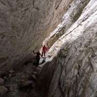
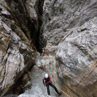
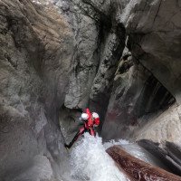
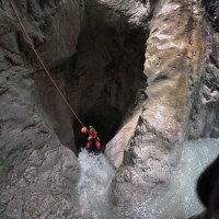
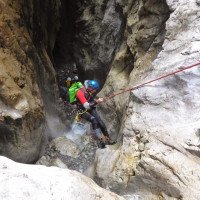
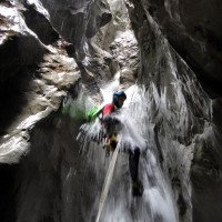
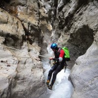
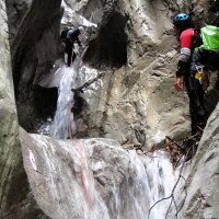
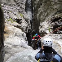
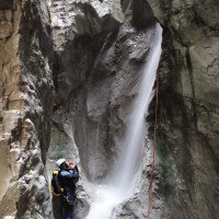
Nach etwa 100m im offenen Schotterbett des Ehnbaches beginnt die Klamm. Nun folgt eine lange Reihe (etwa 30) von kürzeren Abseilern (meist außerhalb des Strahls), bis man nach etwa 2 Stunden das Ende des ersten Klammabschnitts erreicht. Hier kann man erforderlichenfalls steil hinauf zur Piste aussteigen. Die empfehlenswertere Variante führt nach über eine weitere Stunde und 5 auch nicht unattraktive Abseiler sowie eine längere Strecke im Bachbettschotter hinab zum Ausstieg auf die querende Piste.
After about 100m in the open gravel bed of the Ehnbach stream, the gorge begins. Now follows a long series (about 30) of shorter rappels (mostly outside the beam) until you reach the exit of the first section of the gorge after about 2 hours. Here, if necessary, you can climb steeply up to the slope. The more recommendable variant leads after another hour and 5 not unattractive rappels as well as a longer stretch in the stream bed gravel down to the exit on the crossing piste.
Return (1 h):
machine translated
➜
Original language
Auf der Piste immer leicht bergab und über Wanderweg vorbei beim Bahnhof bis zur Hochzirler Straße.
On the slope always slightly downhill and via the hiking trail past the train station to Hochzirler Straße.
Coordinates:
Canyon Start
47.3056°, 11.2826°
↓↑
DMS: 47° 18" 20.16', 11° 16" 57.36'
DM: 47° 18.336", 11° 16.956"
Google Maps
Austria Topo
DMS: 47° 18" 20.16', 11° 16" 57.36'
DM: 47° 18.336", 11° 16.956"
Google Maps
Austria Topo
Canyon End
47.292°, 11.2815°
↓↑
DMS: 47° 17" 31.2', 11° 16" 53.4'
DM: 47° 17.52", 11° 16.89"
Google Maps
Austria Topo
DMS: 47° 17" 31.2', 11° 16" 53.4'
DM: 47° 17.52", 11° 16.89"
Google Maps
Austria Topo
Parking at Entry
47.2854°, 11.2437°
↓↑
DMS: 47° 17" 7.44', 11° 14" 37.32'
DM: 47° 17.124", 11° 14.622"
Google Maps
Austria Topo
DMS: 47° 17" 7.44', 11° 14" 37.32'
DM: 47° 17.124", 11° 14.622"
Google Maps
Austria Topo
parkink clinic - navette possible (descente)
Parking at Exit
47.2785°, 11.2517°
↓↑
DMS: 47° 16" 42.6', 11° 15" 6.12'
DM: 47° 16.71", 11° 15.102"
Google Maps
Austria Topo
DMS: 47° 16" 42.6', 11° 15" 6.12'
DM: 47° 16.71", 11° 15.102"
Google Maps
Austria Topo
navette possible, mais pas necessaire (mountain bike utile) (descente)
Waypoint
47.2949°, 11.2782°
↓↑
DMS: 47° 17" 41.64', 11° 16" 41.52'
DM: 47° 17.694", 11° 16.692"
Google Maps
Austria Topo
DMS: 47° 17" 41.64', 11° 16" 41.52'
DM: 47° 17.694", 11° 16.692"
Google Maps
Austria Topo
bifurcation: à droite ("Solsteinhaus") (descente)
Waypoint
47.3036°, 11.2808°
↓↑
DMS: 47° 18" 12.96', 11° 16" 50.88'
DM: 47° 18.216", 11° 16.848"
Google Maps
Austria Topo
DMS: 47° 18" 12.96', 11° 16" 50.88'
DM: 47° 18.216", 11° 16.848"
Google Maps
Austria Topo
Solen-Alm: bifurcation: sente à droite vers le lit du Ehnbach ("Lärchensteig") (descente)
Literatures:
Map
1:50000
Map
1:25000
Map
Canyoning Book
Alexander Riml / Gunnar Amor
2012
Canyoning Booklet
AIC
2024
Booklet des Canyoning Treffens in Südtirol 2024 - Beschreibungen übernommen nach freundlicher Genehmigung
Cwiki Canyon Info
Descente Canyon Info
Ropewiki Canyon Info
Trip Report (e.g. Blogpost)
Trip Report (e.g. Blogpost)
08.09.2024
Joey CIA
⭐
★★★★★
📖
★★★
⚓
★★★
💧
Normal
Completed ✔
machine translated
➜
Original language
Other users were: Bavarian Canyoning

Zustieg mit MTB (45min) und wandern 1:15std
Schöner Canyon, der Weg Lohnt sich. Gut eingerichtet, schöner Fels, ordentlich Geschiebe im Canyon.
Super Tag!
Access by MTB (45min) and hiking 1:15h
Beautiful canyon, well worth the walk. Well set up, beautiful rock, lots of boulders in the canyon.
Superiore day!
Other users were: Bavarian Canyoning
23.08.2024
Max Rudholzer
⭐
★★★★★
📖
★★★
⚓
★★★
💧
Low
Completed ✔
machine translated
➜
Original language


Landschaftlich faszinierend und extrem lohnend.
Bei Stand 23 ist ein Bohrhaken vorhanden, es fehlen jedoch Lasche und Rapidglied. Die Stelle kann bei diesem Wasserstand aber problemlos abgeklettert werden.
Bei Stelle 18 muss sich eine Verklausung gelöst haben. Hier ist der Haken nur über eine Räuberleiter erreichbar.
Vorsicht beim der Verklausung am Gnaupenloch. Hier kann man leicht Steinschlag auslösen.
Scenic, fascinating and extremely rewarding.
There is a bolt at belay 23, but there is no bolt and rapid link. However, the spot can be downclimbed without any problems at this water level.
An obstruction must have come loose at belay 18. Here the anchor can only be reached via a robber's ladder.
Be careful at the blockage at the Gnaupenloch. It is easy to trigger a rockfall here.
10.08.2024
Gregor Bernsteiner
⭐
★★★★★
📖
★★★
⚓
★★★
💧
Normal
Completed ✔
machine translated
➜
Original language
Sehr schöne Schlucht.
Viel Kies und Geschiebe in der Schlucht.
Beim Gnaupenloch instabile Verklausung, kann man mit Seilgeländer umgehen.
Stände in Ordnung
Very beautiful canyon.
Lots of gravel and debris in the canyon.
At the Gnaupenloch unstable blockage, can be avoided with rope traverses.
Stands in order
25.10.2023
Franz Baumgartner
⭐
★★★★★
📖
★★★
⚓
★★★
💧
Normal
Completed ✔
no translation available
Automatisch importiert von Descente-Canyon.com für Canyon Gnaupenloch
Ancrages ok. Très beau canyon alpin.
(Quelle: https://www.descente-canyon.com/canyoning/canyon-debit/23104/observations.html)
15.10.2023
Jeroen k
⭐
★★★★★
📖
★★★
⚓
★★★
💧
Normal
Completed ✔
no translation available
Automatisch importiert von Descente-Canyon.com für Canyon Gnaupenloch
All anchors ok, all quicklinks in place, single most of the time, best not to add more anchors, as the river bed will again change in time, just be prepared with a bolting kit and know when a storm has hit (this was the case in 2023, hence the new anchors).
(Quelle: https://www.descente-canyon.com/canyoning/canyon-debit/23104/observations.html)
15.10.2023
Jeroen Kirchner
⭐
★★★★★
📖
★★★
⚓
★★★
💧
Normal
Completed ✔
All anchors ok, quicklinks in place, single most of the time, best not to add more since the river bed will change in time but bring a bolting kit just in case and know when a storm has hit (this was the case in 2023). Great with mountainbike.
28.09.2023
Clarissa Linder
⭐
★★★★★
📖
★★★
⚓
★★★
💧
Low
Completed ✔
machine translated
➜
Original language
2 neue Haken gesetzt (Nr. 31 und Nr. 20). Viel Kies und Geschiebe seit letztem Hochwasser. Beim Abseilen im "Gnaupenloch" ist bei der instabilen Verklausung auch einiges an Steinen mitgekommen.
2 new hooks set (No. 31 and No. 20). A lot of gravel and debris since the last flood. When abseiling in the "Gnaupenloch" has also come with the unstable entanglement some stones.
10.07.2023
Patrick Summerer
⭐
★★★★★
📖
★★★
⚓
★★★
💧
Normal
Completed ✔
machine translated
➜
Original language
Bei der Abseilstelle mit Seilgeländer direkt beim "Gnaupenloch" (Steinbogen am Ende des eng eingeschnittenen Abschnitts) ist eine etwas instabile Verklausung, Das Rapidglied zum Abseilen wurde beim Seilgeländer auf die zweite Verankerung versetzt.
At the rappelling point with rope railing directly at the "Gnaupenloch" (stone arch at the end of the narrow cut section) is a somewhat unstable entanglement, The rapid link for rappelling was moved to the second anchorage at the rope railing.
09.03.2023
System User
⭐
★★★★★
📖
★★★
⚓
★★★
no translation available
Info: Teile der Canyonbeschreibung wurden automatisiert übernommen. Konkret die Felder Weblinks, Koordinaten, Rating, Länge des Canyon, Einfachseil Mindestens von https://www.descente-canyon.com/canyoning/canyon/23104
09.03.2023
System User
⭐
★★★★★
📖
★★★
⚓
★★★
no translation available
Daten importiert von https://canyon.carto.net/cwiki/bin/view/Canyons/GnaupenlochCanyon.html
New Report
Please briefly and concisely the most important information of the last tour or important current information about the canyon. If necessary with links to videos, photos, etc..
*
*
*
Esc
Del
Hydrology: