Country:
Schweiz / Switzerland
Region: Kanton Graubünden
Subregion: Region Imboden
Town: (Trin-)Mulin
v4 a5 V
4h45
35min
4h
10min
1055m
800m
255m
27m
2x30m
28
600m
on Foot
Specialities:
Dam § Regulated
Dam § Regulated
Rating:
★★★★★
4.8 (14)
Info:
★★★
2.6 (8)
Belay:
★★★
2.4 (10)
Summary:
machine translated
➜
Original language
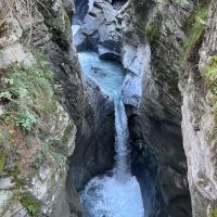
Der Turnigla hat 2 höchst unterschiedliche Abschnitte, weil etwa in der Mitte der Gesamtstrecke eine Wasserableitung in ein Wasserreservoir erfolgt.
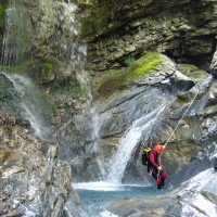
So hat der obere Abschnitt (höchster Abseiler ca. 15m) grundsätzlich einen relativ hohen Wasserdurchsatz, worin auch dessen spezifische Schwierigkeit liegt.
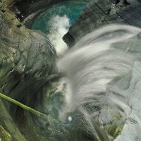
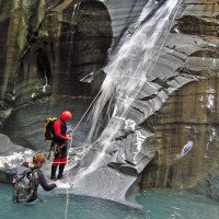
An einer Stelle muss man den Gumpen, in den (10m) hineingeseilt wird durch eine enge Rinne verlassen, in die das gesamte Wasser ziemlich konzentriert aus etwa 9m Höhe hineinprasselt - auch bei "Niedrigwasser" schon eine unangenehme Rückenmassage. Zur Umgehung ist hier beim Stand ein Handlauf in der senkrechten Wand (zur Linken) eingerichtet, der jedoch jeweils eigenständig mit dem notwendigen Strick ausgestattet werden muss (2008). Im oberen Teil sind einige Sprünge möglich.
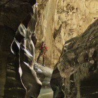
Nach der Wasserableitung (etwa in 960müNN) verbleibt normalerweise nur eine geringe Restwassermenge im Bachbett. Hier steht dann das Ambiente - blaugrauer Schiefer und blaugrüne Färbung der Gumpen - im Vordergrund des Genusses.
Über dem unteren Abschnitt, der sich eigentlich auch für Anfänger eignen würde, hängt jedoch wie ein Damoklesschwert die Gefahr einer nicht vorhersehbaren Wasserzuleitung. Je einmal in den Jahren 2007 und 2008 wurde der Verf. von einer Wasserzuleitung überrascht, das zweite Mal bedingt durch Mängel im Bereich der Elektrizität im Kleinkraftwerk Mulin (links beim Ausstieg). Da beide Fehlfunktionen relativ schnell behoben werden konnten, waren wir zum einen nur relativ kurze Zeit (10 - 20 Min.) dem anschwellenden Wasser ausgesetzt und offenbar nur in dem Umfang wie die Wasserableitung aus dem Turnigla selbst nicht mehr erfolgte, d.h wir hatten nicht mehr Wasser als im oberen Teil. Das würde eine Relativierung der Gefahr bedeuten. Eine mündliche Nachfrage bei Beschäftigten im Kleinkraftwerk Mulin vor Ort ergab jedoch, dass das Wasserreservoir nicht nur durch die Ableitung aus dem Turnigla gespeist wird, sondern auch durch eine zusätzliche Quelle direkt aus dem Berginneren. Deren Schüttung berträgt angeblich bis zu 200 ltr/sec. Die Wasserableitung aus dem Turnigla kommt mit mind. 70 ltr/sec (bei "Niedrigwasser") hinzu. Wird diese gesamte Wassermenge dem unteren Abschnitt zugeführt - oder erfolgt gar eine Spülung - so mag sich jeder selbst die Folgen für die von der Flut überraschten Schluchtler vorstellen. Es gibt zwar immer wieder Bereiche, wo man auf etwas höhere Podeste hinaufklettern kann, aber einen Fluchtweg gibt es weder im oberen noch im unteren Abschnitt - lediglich die Ausstiegsmöglichkeit bei der Wasserableitung.
The Turnigla has 2 highly different parts, because about in the middle of the total route there is a water drainage into a water reservoir.
Thus, the upper part (highest rappel about 15m) has basically a relatively high water flow, wherein also lies its specific difficulty.
At one point you have to leave the pool into which you are rappelling (10m) through a narrow chute, into which all the water fairly concentrated from a height of about 9m pours - even at "low water" already an unpleasant back massage. To avoid this, there is a handrail in the vertical wall (to the left), which has to be equipped with the necessary rope (2008). In the upper part some jumps are possible.
After the water is drained (at about 960m above sea level), usually only a small amount of residual water remains in the streambed. Here, the ambience - blue-gray shale and blue-green coloring of the pools - is then the focus of enjoyment.
However, over the lower part, which would actually be suitable for beginners, hangs like a sword of Damocles the danger of an unpredictable water supply. Once each in 2007 and 2008, the author was surprised by a water supply line, the second time due to defects in the electricity system at the Mulin small power station (left at the exit). Since both malfunctions could be repaired relatively quickly, we were exposed to the swelling water only for a relatively short time (10 - 20 min.) and apparently only to the extent that the water drainage from the Turnigla itself was no longer taking place, i.e. we did not have more water than in the upper part. This would put the danger in perspective. However, a verbal inquiry with employees at the Mulin small power plant on site revealed that the water reservoir is not only fed by the discharge from the Turnigla, but also by an additional spring directly from the interior of the mountain. Its flow is said to be up to 200 ltr/sec. The water discharge from the Turnigla is added with at least 70 ltr/sec (at "low water"). If this entire amount of water is supplied to the lower part - or if there is even a flushing - everyone may imagine the consequences for the gorge dwellers surprised by the flood. There are always areas where one can climb up to somewhat higher platforms, but there is no escape route in either the upper or the lower part - only the possibility to get out when the water is drained.
August - November
South
28.00km²
Summary:
machine translated
➜
Original language
Der Turnigla hat 2 höchst unterschiedliche Abschnitte, weil etwa in der Mitte der Gesamtstrecke eine Wasserableitung in ein Wasserreservoir erfolgt.
So hat der obere Abschnitt (höchster Abseiler ca. 15m) grundsätzlich einen relativ hohen Wasserdurchsatz, worin auch dessen spezifische Schwierigkeit liegt.
An einer Stelle muss man den Gumpen, in den (10m) hineingeseilt wird durch eine enge Rinne verlassen, in die das gesamte Wasser ziemlich konzentriert aus etwa 9m Höhe hineinprasselt - auch bei "Niedrigwasser" schon eine unangenehme Rückenmassage. Zur Umgehung ist hier beim Stand ein Handlauf in der senkrechten Wand (zur Linken) eingerichtet, der jedoch jeweils eigenständig mit dem notwendigen Strick ausgestattet werden muss (2008). Im oberen Teil sind einige Sprünge möglich.
Nach der Wasserableitung (etwa in 960müNN) verbleibt normalerweise nur eine geringe Restwassermenge im Bachbett. Hier steht dann das Ambiente - blaugrauer Schiefer und blaugrüne Färbung der Gumpen - im Vordergrund des Genusses.
Über dem unteren Abschnitt, der sich eigentlich auch für Anfänger eignen würde, hängt jedoch wie ein Damoklesschwert die Gefahr einer nicht vorhersehbaren Wasserzuleitung. Je einmal in den Jahren 2007 und 2008 wurde der Verf. von einer Wasserzuleitung überrascht, das zweite Mal bedingt durch Mängel im Bereich der Elektrizität im Kleinkraftwerk Mulin (links beim Ausstieg). Da beide Fehlfunktionen relativ schnell behoben werden konnten, waren wir zum einen nur relativ kurze Zeit (10 - 20 Min.) dem anschwellenden Wasser ausgesetzt und offenbar nur in dem Umfang wie die Wasserableitung aus dem Turnigla selbst nicht mehr erfolgte, d.h wir hatten nicht mehr Wasser als im oberen Teil. Das würde eine Relativierung der Gefahr bedeuten. Eine mündliche Nachfrage bei Beschäftigten im Kleinkraftwerk Mulin vor Ort ergab jedoch, dass das Wasserreservoir nicht nur durch die Ableitung aus dem Turnigla gespeist wird, sondern auch durch eine zusätzliche Quelle direkt aus dem Berginneren. Deren Schüttung berträgt angeblich bis zu 200 ltr/sec. Die Wasserableitung aus dem Turnigla kommt mit mind. 70 ltr/sec (bei "Niedrigwasser") hinzu. Wird diese gesamte Wassermenge dem unteren Abschnitt zugeführt - oder erfolgt gar eine Spülung - so mag sich jeder selbst die Folgen für die von der Flut überraschten Schluchtler vorstellen. Es gibt zwar immer wieder Bereiche, wo man auf etwas höhere Podeste hinaufklettern kann, aber einen Fluchtweg gibt es weder im oberen noch im unteren Abschnitt - lediglich die Ausstiegsmöglichkeit bei der Wasserableitung.
The Turnigla has 2 highly different parts, because about in the middle of the total route there is a water drainage into a water reservoir.
Thus, the upper part (highest rappel about 15m) has basically a relatively high water flow, wherein also lies its specific difficulty.
At one point you have to leave the pool into which you are rappelling (10m) through a narrow chute, into which all the water fairly concentrated from a height of about 9m pours - even at "low water" already an unpleasant back massage. To avoid this, there is a handrail in the vertical wall (to the left), which has to be equipped with the necessary rope (2008). In the upper part some jumps are possible.
After the water is drained (at about 960m above sea level), usually only a small amount of residual water remains in the streambed. Here, the ambience - blue-gray shale and blue-green coloring of the pools - is then the focus of enjoyment.
However, over the lower part, which would actually be suitable for beginners, hangs like a sword of Damocles the danger of an unpredictable water supply. Once each in 2007 and 2008, the author was surprised by a water supply line, the second time due to defects in the electricity system at the Mulin small power station (left at the exit). Since both malfunctions could be repaired relatively quickly, we were exposed to the swelling water only for a relatively short time (10 - 20 min.) and apparently only to the extent that the water drainage from the Turnigla itself was no longer taking place, i.e. we did not have more water than in the upper part. This would put the danger in perspective. However, a verbal inquiry with employees at the Mulin small power plant on site revealed that the water reservoir is not only fed by the discharge from the Turnigla, but also by an additional spring directly from the interior of the mountain. Its flow is said to be up to 200 ltr/sec. The water discharge from the Turnigla is added with at least 70 ltr/sec (at "low water"). If this entire amount of water is supplied to the lower part - or if there is even a flushing - everyone may imagine the consequences for the gorge dwellers surprised by the flood. There are always areas where one can climb up to somewhat higher platforms, but there is no escape route in either the upper or the lower part - only the possibility to get out when the water is drained.
Access:
machine translated
➜
Original language
Auf der Schweizer A 13 vom Bodensee südwärts bis Chur. Weiter in Richtung San Bernardino. 7 km nach Chur-West von der A 13 ab in Richtung Flims. 5 km nach dem Verlassen der A 13 durchfahren wir ein Tunnel. Gleich nach dessen westlichen Ende rechts ab in Richtung "Trin-Mulin". Über dem Tunnel etwa 100m zurück und dann rechts ab nach Mulin. Direkt nach dieser Abzweigung sehen wir links unterhalb eine Fläche, wo wir das Fahrzeug abstellen können.
On the Swiss A 13 from Lake Constance southward to Chur. Continue in the direction of San Bernardino. 7 km after Chur-West leave the A 13 in the direction of Flims. 5 km after leaving the A 13 we pass through a tunnel. Immediately after its western exit turn right in the direction of "Trin-Mulin". Above the tunnel we go back about 100m and then turn right to Mulin. Immediately after this turnoff we see on the left below an area where we can park the vehicle.
Approach (35 min):
machine translated
➜
Original language
Vom Parkplatz wieder zurück über die Straße "Trin-Mulin" hinweg und jenseits in Richtung NNW den Forstweg aufwärts. Wir passieren die Abzweigung zum Wasserbehälter (Einstieg unterer Abschnitt), später das meist trockene Bachbett des Trimosa und erreichen schließlich die Brücke über die Turnigla. Wenige Meter oberhalb der Brücke steigen wir vom orograf. linken Ufer ein.
From the parking lot back across the road "Trin-Mulin" and beyond in the direction NNW up the forest road. We pass the turnoff to the water reservoir (entry lower part), later the mostly dry streambed of the Trimosa and finally reach the bridge over the Turnigla. A few meters above the bridge we climb from the orographic left bank.
Tour (4 h):
machine translated
➜
Original language
Im oberen Teil kräftiger Strahl, aus dem man sich in aller Regel gut heraushalten kann (siehe aber auch oben unter "Charakteristik"). Reichlich Gelegenheit zum Springen.
Sofern man den unteren Abschnitt riskieren will, das Ambiente ist beeindruckend.
Seit Mitte 2009 verlangen die Betreiber des E-Werks mit Wasserbehälter, dass ihre Anlagen in keiner Weise mehr betreten werden dürfen. Das gilt auch für eine Integralbegehung. Neuerdings (Febr. 2010) hört man auch von einem angeblich bevorstehendem Verbot einer Schluchtbegehung unterhalb der Wasserfassung ohne dass bislang Einzelheiten bekannt sind (vgl.: http://www.descente-canyon.com/forums/viewtopic.php?id=12092).
Inzwischen ist das Verbot eines Zustiegs sowie des Ausstiegs im Ort nach links Realität.
In the upper part powerful jet, from which one can usually keep out well (but see also above under "Characteristics"). Plenty of opportunity to jump.
If you want to risk the lower part, the ambience is impressive.
Since mid-2009, the operators of the electric plant with water tank require that their facilities may not be entered in any way. This also applies to an integral walk-through. Recently (Feb. 2010) one also hears about an allegedly imminent ban of a canyon walk below the water reservoir without any details being known so far (cf.: http://www.descente-canyon.com/forums/viewtopic.php?id=12092).
In the meantime, the ban on access and exit in the village to the left is a reality.
Return (10 min):
machine translated
➜
Original language
Bei Ausstieg am Wasserbehälter: Über Stahlstifte und Drahtseil-Handlauf auf den Betonsteg (auch Abseilen links an der Wasserfassung vorbei direkt zum Betonsteg ist möglich), um das Metallgitter herumhangeln, über den externen Wasserbehälter und auf dem Feldweg hinunter zum Aufstiegsweg. Auf diesem zurück zum Fahrzeug.
Bei Ausstieg nach dem 2. Abschnitt: Beim E-Werk links hinaus, südwärts über den Parkplatz und dann die Straße in östlicher Richtung ("Trin") bis zum abgestellten Fahrzeug.
On exit at the water tank: via steel pins and wire rope handrail onto the concrete footbridge (rappeling left past the water intake directly to the concrete footbridge is also possible), shimmy around the metal grating, over the external water tank and down along the field path to the ascent path. Return to the vehicle along this path.
On exit after the 2nd part: Exit left at the E-Werk, head south across the parking lot and then down the road in an easterly direction ("Trin") to the parked vehicle.
Coordinates:
Canyon Start
46.8388°, 9.34104°
↓↑
DMS: 46° 50" 19.68', 9° 20" 27.74'
DM: 46° 50.328", 9° 20.462"
Google Maps
SwissTopo
DMS: 46° 50" 19.68', 9° 20" 27.74'
DM: 46° 50.328", 9° 20.462"
Google Maps
SwissTopo
Canyon End
46.8335°, 9.3401°
↓↑
DMS: 46° 50" 0.6', 9° 20" 24.36'
DM: 46° 50.01", 9° 20.406"
Google Maps
SwissTopo
DMS: 46° 50" 0.6', 9° 20" 24.36'
DM: 46° 50.01", 9° 20.406"
Google Maps
SwissTopo
Parking Entry and Exit
46.8321°, 9.34562°
↓↑
DMS: 46° 49" 55.56', 9° 20" 44.23'
DM: 46° 49.926", 9° 20.737"
Google Maps
SwissTopo
DMS: 46° 49" 55.56', 9° 20" 44.23'
DM: 46° 49.926", 9° 20.737"
Google Maps
SwissTopo
(descente_3)
Waypoint
46.8362°, 9.34037°
↓↑
DMS: 46° 50" 10.32', 9° 20" 25.33'
DM: 46° 50.172", 9° 20.422"
Google Maps
SwissTopo
DMS: 46° 50" 10.32', 9° 20" 25.33'
DM: 46° 50.172", 9° 20.422"
Google Maps
SwissTopo
captage (descente)
Literatures:
Map
1:25000
Canyoning Book
Emmanuel Belut / Laurence Boyé / Thomas Guigon
Association Openbach
2015
9782746679450
Canyoning Book
Canyoning Book
F. Baumgartner / A. Brunner / D. Zimmermann
2010
Canyoning Book
Canyoning Book
Stéphane Coté / Caracal et les Sancho Panza
2009
Cwiki Canyon Info
Descente Canyon Info
Ropewiki Canyon Info
Other Canyon Info
Schlucht.ch Canyon Info
02.01.2025
Airmax
⭐
★★★★★
📖
★★★
⚓
★★★
💧
Low
Completed ✔
machine translated
➜
Original language
Sehr gute Bedingungen. Kein Eis im Canyon. Einige Sprünge möglich.
Very good conditions. No ice in the canyon. Some jumps possible.
14.12.2024
Patrik
⭐
★★★★★
📖
★★★
⚓
★★★
💧
Normal
Completed ✔
machine translated
➜
Original language
Aktuell sehr gute Bedingungen. Kein Eis vorhanden.
Currently very good conditions. No ice available.
10.11.2024
Patrik B
⭐
★★★★★
📖
★★★
⚓
★★★
no translation available
Automatisch importiert von Schlucht.ch für Canyon Turnigla, Wasserstand: "Normal -" Verankerungen: "Ok"
(Quelle: https://schlucht.ch/schluchten-der-schweiz-liste/1049-turnigla)
10.11.2024
Bina
⭐
★★★★★
📖
★★★
⚓
★★★
💧
Normal
Completed ✔
machine translated
➜
Original language
Other users were: Patrik Bartel
Zwischen 11- 11.30Uhr einsteigen, da ist der Sonnenstand im Moment sehr schön.
Board between 11 and 11.30 a.m., when the sun is at its best.
Other users were: Patrik Bartel
04.11.2024
rostolane
⭐
★★★★★
📖
★★★
⚓
★★★
💧
Normal
Completed ✔
no translation available
Automatisch importiert von Descente-Canyon.com für Canyon Turnigla
Merveilleuse journée avec la golden team suisse de Thierry et les parisiens . Horaire parfait départ du parking 9h40 pour avoir le soleil dans le canyon. Entre 3.7 ou 3.9 pour la note il y a presque tout dans. Ce canyon. ça fait du bien un canyon après un Segnes difficile... Fait en étanche et cagoule 7 mm pas eu froid du tout. Même un peu chaud.
(Quelle: https://www.descente-canyon.com/canyoning/canyon-debit/21997/observations.html)
03.11.2024
Bigoudi88
⭐
★★★★★
📖
★★★
⚓
★★★
💧
Normal
Completed ✔
no translation available
Automatisch importiert von Descente-Canyon.com für Canyon Turnigla
Magnifique canyon, fait en intégralité
(Quelle: https://www.descente-canyon.com/canyoning/canyon-debit/21997/observations.html)
03.11.2024
tias75
⭐
★★★★★
📖
★★★
⚓
★★★
💧
Normal
Completed ✔
no translation available
Automatisch importiert von Descente-Canyon.com für Canyon Turnigla
Sublime canyon : beau et ludique !
(Quelle: https://www.descente-canyon.com/canyoning/canyon-debit/21997/observations.html)
03.11.2024
K1000zede63Papaya
⭐
★★★★★
📖
★★★
⚓
★★★
💧
Normal
Completed ✔
no translation available
Automatisch importiert von Descente-Canyon.com für Canyon Turnigla
A midi Turni c'est le paradis !!!
(Quelle: https://www.descente-canyon.com/canyoning/canyon-debit/21997/observations.html)
30.10.2024
AlbertoCabrera
⭐
★★★★★
📖
★★★
⚓
★★★
💧
Normal
Completed ✔
no translation available
Automatisch importiert von Descente-Canyon.com für Canyon Turnigla
(Quelle: https://www.descente-canyon.com/canyoning/canyon-debit/21997/observations.html)
08.09.2024
Bina
⭐
★★★★★
📖
★★★
⚓
★★★
💧
Normal
Completed ✔
no translation available
Automatisch importiert von Descente-Canyon.com für Canyon Turnigla
(Quelle: https://www.descente-canyon.com/canyoning/canyon-debit/21997/observations.html)
08.09.2024
Patrik B
⭐
★★★★★
📖
★★★
⚓
★★★
no translation available
Automatisch importiert von Schlucht.ch für Canyon Turnigla, Wasserstand: "Schön" Verankerungen: "Ok"
Es scheint wieder normal Wasser entnommen zu werden. Der Wasserentnahmestollen war beleuchtet? Wie immer wunderschön.
(Quelle: https://schlucht.ch/schluchten-der-schweiz-liste/1049-turnigla)
08.09.2024
Bina
⭐
★★★★★
📖
★★★
⚓
★★★
💧
Normal
Completed ✔
machine translated
➜
Original language
Other users were: Wolfgang Patrik Bartel
Ganze Schlucht begangen.
Bei der Fassung scheint die Wasserentnahme wieder normal zu sein (etwas komisch fanden wir das Licht im Wasserentnahmestollen).
Wie immer tolle Schlucht.
Walked the whole canyon.
The water extraction seems to be back to normal at the socket (we found the light in the water extraction tunnel a bit strange).
As always, a great canyon.
Other users were: Wolfgang Patrik Bartel
26.08.2024
K1000zede63
⭐
★★★★★
📖
★★★
⚓
★★★
💧
Normal
Completed ✔
no translation available
Automatisch importiert von Descente-Canyon.com für Canyon Turnigla
Environ 400 KW à la centrale de Mulin. DC/DC+
(Quelle: https://www.descente-canyon.com/canyoning/canyon-debit/21997/observations.html)
17.08.2024
Bernhard
⭐
★★★★★
📖
★★★
⚓
★★★
💧
Normal
Completed ✔
machine translated
➜
Original language
Fantastische Tour
Sind Oberen und unteren Teil begangen. Bei der Ableitung in der Mitte haben wir gesehen dass eine Nebenleitung orogr. Rechts viel Wasser rein leitet. Dadurch herrliche Bedingungen im unteren Teil. Jedoch dafür sehr kalt und anspruchsvoll - mehrfach im starken Wasserfall abseilen und Siphone umgehen.
2h 45m für beide Teile zu dritt
Fantastic tour
Walked the upper and lower sections. At the drainage in the middle we saw that a secondary line orographic to the right carries a lot of water in. This meant wonderful conditions in the lower section. However, very cold and demanding - rappel several times in the strong waterfall and bypass Siphone.
2h 45m for both parts with three of us
09.08.2024
Alex Engelhardt
⭐
★★★★★
📖
★★★
⚓
★★★
no translation available
Automatisch importiert von Schlucht.ch für Canyon Turnigla, Wasserstand: "Ca. 380kw" Verankerungen: "Alles gut im oberen Teil"
Oberer Teil. Gute Bedingungen. Keine bemerkenswerten Veränderungen zum Frühjahr. KW lässt aktuell fast 1zu1 durch. Baustelle am Ausstieg oberer Teil
(Quelle: https://schlucht.ch/schluchten-der-schweiz-liste/1049-turnigla)
09.08.2024
Alex Engelhardt
⭐
★★★★★
📖
★★★
⚓
★★★
💧
High
Completed ✔
no translation available
Automatisch importiert von Descente-Canyon.com für Canyon Turnigla
Top conditions, KW Mulin ca.380KW, all ankers good, we went out after the upper part, water level nearly the same at lower part
(Quelle: https://www.descente-canyon.com/canyoning/canyon-debit/21997/observations.html)
09.08.2024
Waldemar Engelhardt
⭐
★★★★★
📖
★★★
⚓
★★★
💧
Normal
Completed ✔
machine translated
➜
Original language
Other users were: Alex Engelhardt
Top Bedingungen, alle Anker ok, nur oberen Teil begangen. KW lässt Wasser fast 1 zu 1 durch. Baustelle beim KW. Durchfluss ca. 380KW
Top conditions, all anchors ok, only the upper part has been walked on. KW lets water through almost 1 to 1. Construction site at KW. Flow rate approx. 380KW
Other users were: Alex Engelhardt
21.04.2024
sascha
⭐
★★★★★
📖
★★★
⚓
★★★
no translation available
Automatisch importiert von Schlucht.ch für Canyon Turnigla, Wasserstand: "mittel - 300kw Kraftwerk Mulin - Unterer Abschnitt hatte auch gleich viel Wasser!" Verankerungen: "sehr gut"
eine schraube etwas locker - der nächste bitte ein 19er schlüssel mitnehmen
(Quelle: https://schlucht.ch/?view=article&id=1049&Itemid=203)
05.04.2024
Patrik
⭐
★★★★★
📖
★★★
⚓
★★★
💧
Low
Completed ✔
machine translated
➜
Original language
Im Moment gute Verhältnisse. Im unteren Teil eher rutschig. Einige Stämme vom letzten Fönsturm vorhanden, stören aber nicht. Ca. 300KW - Hexenkessel ohne Probleme.
Good conditions at the moment. Rather slippery in the lower part. Some logs from the last foehn storm, but not disturbing. Approx. 300KW - Hexenkessel without problems.
07.01.2024
Sallemann
⭐
★★★★★
📖
★★★
⚓
★★★
💧
Normal
Completed ✔
no translation available
Automatisch importiert von Descente-Canyon.com für Canyon Turnigla
Water level was almost 400kw causing no problems. The water was a bit murky, the grip okay. We fixed the bolt before the last abseil.
(Quelle: https://www.descente-canyon.com/canyoning/canyon-debit/21997/observations.html)
07.01.2024
Sarah Allemann
⭐
★★★★★
📖
★★★
⚓
★★★
no translation available
Automatisch importiert von Schlucht.ch für Canyon Turnigla, Wasserstand: "mittel bei knapp 400kw" Verankerungen: "gut"
Noch kein Eis in der Schlucht, Wasser leicht trüb, griffig zu gehen; Pools prüfen wegen Kies, Plättchen am vorletzten Stand ergänzt; bei Schneefall coole Stimmung ;)
(Quelle: https://schlucht.ch/schluchten-der-schweiz.html?cid=49)
14.12.2023
Bubtore
⭐
★★★★★
📖
★★★
⚓
★★★
💧
High
Completed ✔
no translation available
Automatisch importiert von Descente-Canyon.com für Canyon Turnigla
Débit sportif dans la partie haute, comme sur la photo du livre, mais une adhérence incroyable.Quand le premier du groupe est arrivé au bassin du captage, la rétention était en train d'être purgée. Par conséquent, la majorité du groupe voulait sortir, étant donné que la vasque sous le captage était toute blanche pendant plusieurs minutes.À ma connaissance jusque là, Turnigla n'a pas de bassin souterrain, ni de possibilité de déverser d'autres rivière. Par contre, avec un peu de recherche, j'ai découvert qu'il y a à l'endroit où se trouve le captage, une grosse source d'eau qui part direct vers la centrale électrique et n'est visible nulle part. Et celle ci peut peut facilement avoir le double du débit dans Turnigla amont. Logiquement, si la centrale est en arrêt, on peut se retrouver avec jusqu'à trois fois plus d'eau dans le canyon que ce qu'il y avait avant la station.
(Quelle: https://www.descente-canyon.com/canyoning/canyon-debit/21997/observations.html)
29.10.2023
Bina
⭐
★★★★★
📖
★★★
⚓
★★★
💧
Normal
Completed ✔
no translation available
Automatisch importiert von Descente-Canyon.com für Canyon Turnigla
A lot has changed in six months. Trees, metal pipes that have been there for years are gone. Some new trees, but not disturbing. Many jumps possible.On the second last abseil only the screw is there, it is now a mandatory jump.
(Quelle: https://www.descente-canyon.com/canyoning/canyon-debit/21997/observations.html)
08.10.2023
charly67
⭐
★★★★★
📖
★★★
⚓
★★★
💧
Normal
Completed ✔
no translation available
Automatisch importiert von Descente-Canyon.com für Canyon Turnigla
Turnigla intégral avec de très belles conditions !
(Quelle: https://www.descente-canyon.com/canyoning/canyon-debit/21997/observations.html)
07.10.2023
Jeroen k
⭐
★★★★★
📖
★★★
⚓
★★★
💧
Normal
Completed ✔
no translation available
Automatisch importiert von Descente-Canyon.com für Canyon Turnigla
Warm temps and cold pools :) some pools are with gravel and need to be checked
(Quelle: https://www.descente-canyon.com/canyoning/canyon-debit/21997/observations.html)
02.10.2023
Christian Balla
⭐
★★★★★
📖
★★★
⚓
★★★
💧
Normal
Completed ✔
machine translated
➜
Original language
Video zur Tour: https://youtube.com/shorts/WLSBZKCZE78
Tour video: https://youtube.com/shorts/WLSBZKCZE78
29.09.2023
Wolfgang
⭐
★★★★★
📖
★★★
⚓
★★★
💧
High
Completed ✔
machine translated
➜
Original language
Noch etwas mehr Wasser aber gut machbar. Im unteren Teil fehlt in einem Pool der Haken der hilfreich zum Rausklettern wäre; also entweder sehr geschickt sein oder untern durchtauchen
Still a little more water but well doable. In the lower part in a pool the hook is missing which would be helpful to climb out; so either be very skillful or dive through underneath
09.03.2023
System User
⭐
★★★★★
📖
★★★
⚓
★★★
no translation available
Info: Teile der Canyonbeschreibung wurden automatisiert übernommen. Konkret die Felder Weblinks, Koordinaten, Rating, Länge des Canyon, Einfachseil Mindestens von https://www.descente-canyon.com/canyoning/canyon/21997
09.03.2023
System User
⭐
★★★★★
📖
★★★
⚓
★★★
no translation available
Daten importiert von https://canyon.carto.net/cwiki/bin/view/Canyons/TurniglaCanyon.html
28.07.2022
Bubtore
⭐
★★★★★
📖
★★★
⚓
★★★
💧
Normal
Completed ✔
machine translated
➜
Original language
Alles begangen, im unteren Teil ist ein Haken mitsamt Fels rausgeflogen. Etwa 150kg an Gestein sind direkt neben mir gelandet, Glück gehabt. Die Stelle kann man eigentlich auch Abklettern.
Everything was climbed, in the lower part an anchor flew out together with the rock. About 150 kg of rock landed right next to me, lucky me. The place can actually also be downclimbed.
03.10.2019
Christian Balla
⭐
★★★★★
📖
★★★
⚓
★★★
🌊
Crazy
Completed ✔
machine translated
➜
Original language
Video zur Tour: https://youtu.be/_nGti8ful9U
Tour video: https://youtu.be/_nGti8ful9U
10.11.2018
Christian Balla
⭐
★★★★★
📖
★★★
⚓
★★★
💧
Normal
Completed ✔
machine translated
➜
Original language
Video zur Tour: https://youtu.be/Vha4v42dXV8
Tour video: https://youtu.be/Vha4v42dXV8
New Report
Please briefly and concisely the most important information of the last tour or important current information about the canyon. If necessary with links to videos, photos, etc..
*
*
*
Esc
Del
Hydrology: