not as difficult
Selvano
v3 a3 II
2h50
10min
2h30
10min
470m
260m
210m
12m
1x30m
13
1000m
Car optional
Rating:
★★★★★
2.6 (2)
Info:
★★★
0 ()
Belay:
★★★
0 ()
Summary:
machine translated
➜
Original language
Nicht sehr tief eingeschnittener Waldgraben zum Abseilen
Not very deep forest canyon for rappeling
South
Summary:
machine translated
➜
Original language
Nicht sehr tief eingeschnittener Waldgraben zum Abseilen
Not very deep forest canyon for rappeling
Access:
machine translated
➜
Original language
Von Florenz westwärts auf der A 11 oder von La Spezia auf der A 12 in südlicher Richtung, dann von der A 12 bei Viareggio ostwärts abzweigend auf die A 11, erreichen wir Lucca. Von hier fahren wir das Tal des Fiume Serchio in nördlicher Richtung der SP 20 aufwärts nach Borgo (gut 21 km) und dann noch 9 km am orograf. rechten Ufer weiter, bis eine Straße nach Fábbriche di Vállico in Richtung WSW abbiegt. Wir folgen der Straße - SP 37 - am aufgestauten Turrite Cava entlang durch einige Tunnels und kommen nach gut 5 km einer Brücke, die rechts über den Fluss zu einigen verfallenen Häusern(Molini) führt (wenige Meter weiter auf der Hauptstraße sieht man rechts - unten - am Fluss einen Lagerplatz). Bei der Brücke ist genügend Platz für das erste Fahrzeug.
Mit dem zweiten fahren wir weiter bis zu den ersten Häusern von Fábbriche (7,5 km ab Abzweigung) und biegen dort in spitzem Winkel rechts hinauf ab nach Vállico di Sotto (weitere 3 km). Hier können wir auf dem Platz am Eingang des Dorfes unser zweites Fahrzeug abstellen.
From Florence westwards on the A 11 or from La Spezia on the A 12 in a southerly direction, then branching off eastwards from the A 12 at Viareggio onto the A 11, we reach Lucca. From here we go up the valley of the Fiume Serchio in a northerly direction on SP 20 to Borgo (a good 21 km) and then continue along the orographic right bank for another 9 km until a road turns WSW to Fábbriche di Vállico. We follow the road - SP 37 - along the dammed Turrite Cava through some tunnels and after a good 5 km we come to a bridge that leads to the right over the river to some dilapidated houses(Molini)(a few meters further on the main road we see on the right - below - at the river a campground). At the bridge there is enough space for the first vehicle. \With the second we continue to the first houses of Fábbriche (7.5 km from the junction) and there we turn right at an acute angle up to Vállico di Sotto (another 3 km). Here we can park our second vehicle in the square at the entrance to the village.
Approach (10 min):
machine translated
➜
Original language
Vom Parkplatz und dem großen Baum führt ein Sträßchen in südöstlicher Richtung bergab (zum Friedhof - cimitero). Vor der Brücke über den Bach nehmen wir den Weg rechts hinunter, queren dann den Bach nach links und steigen dann nach dieser Steinbrücke an geeigneter Stelle rechts hinunter in das Bachbett des Rio Selvano. Alternativ kann man auch mit dem Auto das kleine Strässchen hinunter fahren und es dann beim Friedhof abstellen. Auch von hier dann in südwestlicher Richtung zum Bachbett.
From the parking lot and the large tree, a small road leads downhill in a southeasterly direction (to the cemetery - cimitero). Before the bridge over the stream, take the path down to the right, then cross the stream to the left and after this stone bridge, at a suitable point, descend to the right into the streambed of the Rio Selvano. Alternatively, you can drive down the small road and park your car at the cemetery. Also from here then in a southwesterly direction to the streambed.
Tour (2 h 30):
machine translated
➜
Original language
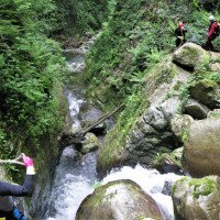
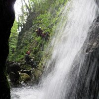
Waldgraben, der im Verlauf an Qualität gewinnt. Siehe auch Fotos u. Video.
Forest canyon that gains in quality as it progresses.
Return (10 min):
machine translated
➜
Original language
Unmittelbar nach der Steinbrücke rechts hinauf und über die Brücke den Maultierpfad hinunter zu den verfallenen Häusern und dem Auto jenseits der Brücke über den Turrite Cava.
Immediately after the stone bridge up to the right and over the bridge down the mule track to the dilapidated houses and the car beyond the bridge over the Turrite Cava.
Coordinates:
Canyon Start
Canyon End
Parking at Entry
P1 Friedhof
Parking at Entry
P2 unterhalb der Ortschaft
Parking at Exit
neben der Straße vor der alten Brücke
Literatures:
Map
1:25000
Canyoning Book
Stéphane Coté / Caracal et les Sancho Panza
2009
Cwiki Canyon Info
Descente Canyon Info
Ropewiki Canyon Info
Other Canyon Info
Other Canyon Info
16.08.2024
massy
⭐
★★★★★
📖
★★★
⚓
★★★
💧
Low
Completed ✔
no translation available
Automatisch importiert von Descente-Canyon.com für Canyon Pili
(Quelle: https://www.descente-canyon.com/canyoning/canyon-debit/21970/observations.html)
01.06.2024
West Canyon
⭐
★★★★★
📖
★★★
⚓
★★★
💧
Normal
Completed ✔
no translation available
Automatisch importiert von Descente-Canyon.com für Canyon Pili
(Quelle: https://www.descente-canyon.com/canyoning/canyon-debit/21970/observations.html)
31.05.2024
Fabrizio Cavazzuti
⭐
★★★★★
📖
★★★
⚓
★★★
💧
Normal
Completed ✔
no translation available
Automatisch importiert von Descente-Canyon.com für Canyon Pili
Fatto anche parte a monte, Riomaggiore. Armi ok
(Quelle: https://www.descente-canyon.com/canyoning/canyon-debit/21970/observations.html)
29.05.2024
ABBY
⭐
★★★★★
📖
★★★
⚓
★★★
💧
Normal
Completed ✔
no translation available
Automatisch importiert von Descente-Canyon.com für Canyon Pili
l'aqualand du coin malgré quelques troncs d'arbre entrée par un affluent RD au lieu de RG.
(Quelle: https://www.descente-canyon.com/canyoning/canyon-debit/21970/observations.html)
20.04.2024
filipe
⭐
★★★★★
📖
★★★
⚓
★★★
💧
Normal
Completed ✕
no translation available
Automatisch importiert von Descente-Canyon.com für Canyon Pili
(Quelle: https://www.descente-canyon.com/canyoning/canyon-debit/21970/observations.html)
09.03.2023
System User
⭐
★★★★★
📖
★★★
⚓
★★★
no translation available
Info: Teile der Canyonbeschreibung wurden automatisiert übernommen. Konkret die Felder Weblinks, Koordinaten, Rating, Länge des Canyon, Einfachseil Mindestens von https://www.descente-canyon.com/canyoning/canyon/21970
09.03.2023
System User
⭐
★★★★★
📖
★★★
⚓
★★★
no translation available
Daten importiert von https://canyon.carto.net/cwiki/bin/view/Canyons/SelvanoCanyon.html
New Report
Please briefly and concisely the most important information of the last tour or important current information about the canyon. If necessary with links to videos, photos, etc..
*
*
*
Esc
Del
Hydrology:


