difficile
Ochsenschlucht (unterer Teil)
Pays:
Österreich / Austria
Région: Kärnten
Sous-régione: Bezirk Spittal an der Drau
Ville: Berg im Drautal
v3 a5 IV
3h
0min
3h
0min
850m
700m
150m
15m
40m +30m
10
Voiture facultative
Évaluation:
★★★★★
3.3 (2)
Info:
★★★
0 ()
Belay:
★★★
0 ()
Résumé:
traduction alternative
➜
Langue originale
WICHTIG: Die Begehung der Schlucht muss angemeldet werden! Kontaktdaten siehe Anfahrt.
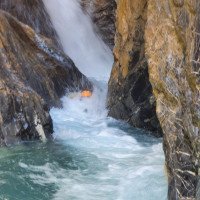
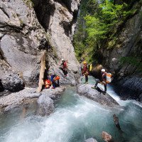
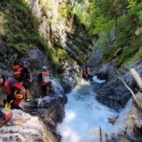
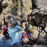
Die Schlucht ist sehr aquatisch mit teilweise turbulenten Gumpen und wuchtigen Wasser.
Unbedingt den Wasserstand kontrollieren und nur bei stabilen Wetterbedingungen einsteigen!
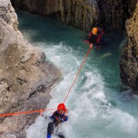
Bei einigen Stellen empfiehlt es sich eine Seilbahn aufzubauen, dass nicht die Ganze Gruppe durch die turbulenten Gumpen muss, dementsprechend sollte 30m – 40m Seile mitgeführt werden um genügend Seil für die Seilbahnen zu haben.
Die Schlucht selbst ist wunderschön und definitiv etwas für Aquatik-Fans!####merge-infos#### Grading: v4 a4 IV Timing: 1h30/3h/10min####merge-start####Landschaftlich schöner aquatischer Canyon mit viel Wasser.####merge-end####
IMPORTANT: The access to the canyons must be announced! For contact details see approach.
The canyon is very aquatic, with sometimes turbulent pools and bulging water.
Be sure to check the water level and enter only in stable weather conditions!
In some places it is recommended to build a ropeway, so that the whole group does not have to go through the turbulent pools, accordingly 30m - 40m ropes should be carried to have enough rope for the ropeways.
The canyon itself is beautiful and definitely something for aquatic fans!####merge-infos#### Grading: v4 a4 IV Timing: 1h30/3h/10min####merge-start####Scenic aquatic canyon with lots of water.####merge-end####
Partie
Nom
Difficulté
Approche
Tour
Retour
Résumé:
traduction alternative
➜
Langue originale
WICHTIG: Die Begehung der Schlucht muss angemeldet werden! Kontaktdaten siehe Anfahrt.
Die Schlucht ist sehr aquatisch mit teilweise turbulenten Gumpen und wuchtigen Wasser.
Unbedingt den Wasserstand kontrollieren und nur bei stabilen Wetterbedingungen einsteigen!
Bei einigen Stellen empfiehlt es sich eine Seilbahn aufzubauen, dass nicht die Ganze Gruppe durch die turbulenten Gumpen muss, dementsprechend sollte 30m – 40m Seile mitgeführt werden um genügend Seil für die Seilbahnen zu haben.
Die Schlucht selbst ist wunderschön und definitiv etwas für Aquatik-Fans!####merge-infos#### Grading: v4 a4 IV Timing: 1h30/3h/10min####merge-start####Landschaftlich schöner aquatischer Canyon mit viel Wasser.####merge-end####
IMPORTANT: The access to the canyons must be announced! For contact details see approach.
The canyon is very aquatic, with sometimes turbulent pools and bulging water.
Be sure to check the water level and enter only in stable weather conditions!
In some places it is recommended to build a ropeway, so that the whole group does not have to go through the turbulent pools, accordingly 30m - 40m ropes should be carried to have enough rope for the ropeways.
The canyon itself is beautiful and definitely something for aquatic fans!####merge-infos#### Grading: v4 a4 IV Timing: 1h30/3h/10min####merge-start####Scenic aquatic canyon with lots of water.####merge-end####
Accès:
traduction alternative
➜
Langue originale
Anfahrt:
Auf der A10 beim Knoten Spital abfahren in Richtung Lienz auf der B100. Der B100 für 34km folgen (ca 30 min) bis man nach Berg an der Drau kommt. Beim Bahnhof Berg biegt man links ab direkt über die Brücke, die über die Drau führt. Hier bleibt man auf der Straße für ca 2,5km bis man zur Radlerstation „Sandhof kommt“. Hier fährt man noch ca für 150m weiter auf der Straße, überquert dabei den Bach der Ochsenschlucht (Feistritz), ehe links – direkt nach dem Bach – der Parkplatz auftaucht (Picknickplatz). Hier kann man die Fahrzeuge mit den trockenen Sachen parken. Generell sollte der Parkplatz genutzt werden um die Mehrzahl der Autos dort abzustellen. Am oberen Parkplatz ist die Parkplatzanzahl limitiert (2 PKW). Am unteren Parkplatz kann dann schon das Equipment vorbereitet werden. Auch der Neoprenanzug kann bereits hier angezogen werden (Zustieg vom oberen Parkplatz ca 15min durch abschüssiges Gelände.
WICHTIG: Bevor die Schlucht begangen wird muss um Erlaubnis gefragt werden (Am besten am Vortag). Hierfür bei Mario Duller von Ares Canyoning anrufen (+43 676 844425280; office@bikeschule.at). Mario hat die Schlucht gepachtet und kennt den Bauern über dessen Grund die private Zufahrtsstraße geht!
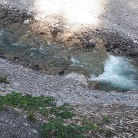
Um zum oberen Parkplatz zu gelangen fährt man wieder zurück in Richtung Radlerstation Sandhof. Direkt beim Sandhof führt rechts die Straße bergauf. Nach ca 500m führt rechts eine Schotterstraße bergabwärts, die durch einen großen Baumstamm versperrt ist. Hier aussteigen und bis zur Wehranlage des Baches gehen für die Wasserkontrolle. Es bringt nichts unteren Parkplatz am Bach die Kontrolle durchzuführen, weil bei der Wehranlage das Wasser abgeleitet wird! Ein Referenzfoto des Wasserstandes unserer Begehung findet man weiter unten, hierbei handelt es sich um den „Normalwasserstand“, der aber schon bei der einen oder anderen Stelle fordernd werden kann.
Ist der Wasserstand ok, fährt man die Straße für ca 3km bergaufwärts. Nach einigen Serpentinen im Wald kommt man bei einer Alm raus wo man sich noch rechts hält. Man fährt nochmal kurz in den Wald ehe man dann wieder bei der Alm rauskommt und man direkt am Bauernhof und einem Rotwildgehege vorbei fährt. Die asphaltierte Straße geht über in einen Schotterweg, der weiter hangaufwärts führt. Man fährt wieder in den Wald, bei Abbiegungen hält man sich rechts, eher man nach 500m am oberen Parkplatz ankommt (der Weg zur Schlucht geht direkt von der Schotterstraße rechts hangabwärts)
Approach:
Exit the A10 at the Spital junction in the direction of Lienz on the B100. Follow the B100 for 34km (approx. 30 min) until you reach Berg an der Drau. At the train station Berg turn left and cross the bridge over the river Drau. Here you stay on the road for about 2,5km until you reach the cycling station "Sandhof". Here you continue on the road for about 150m, crossing the stream of the Ochsenschlucht (Feistritz), before on the left - directly after the stream - the parking lot appears (picnic area). Here you can park the vehicles with the dry things. In general, the parking lot should be used to park the majority of cars there. At the upper parking lot the number of parking spaces is limited (2 cars). At the lower parking lot the equipment can already be prepared. Also the wetsuit can be put on already here (access from the upper parking lot about 15min through sloping terrain.
IMPORTANT: Before entering the canyons you have to ask for permission (best the day before). For this call Mario Duller from Ares Canyoning (+43 676 844425280; office@bikeschule.at). Mario has leased the canyon and knows the farmer over whose land the private access road goes!
To get to the upper parking lot, head back in the direction of the Sandhof bike station. Directly at the Sandhof the road leads uphill on the right. After about 500m, a gravel road leads downhill to the right, blocked by a large tree trunk. Get off here and walk to the weir of the stream for water control. It is useless to check the water level at the lower parking lot of the stream, because the water is diverted at the weir! A reference photo of the water level of our walk can be found below, this is the "normal water level", which can be challenging at one point or another.
If the water level is ok, you drive the road for about 3km uphill. After some serpentines in the forest you come out at an alp where you keep to the right. You drive again briefly into the forest before you come out again at the mountain pasture and you drive directly past the farm and a red deer enclosure. The asphalt road turns into a gravel road that leads further up the slope. Enter the forest again, keep to the right at the turn-offs, rather after 500m you arrive at the upper parking lot (the path to the canyon goes directly from the gravel road downhill to the right).
Approche (0 min):
traduction alternative
➜
Langue originale
Man folgt dem Weg einfach hangabwärts. Der zuerst sehr breite weg wird immer schmäler und wird immer mehr zum Jägerpfad, der direkt in die Schlucht führt. Die Trittspuren sind aber klar erkennbar.
Aufstieg zu Fuß vom unteren Parkplatz ca. 90 min. Dem Schotterbett bis zu einer Wehranlage mit Wasserableitung folgen, dann links hinauf zu einer Asphaltstraße mit Fahrverbot. Auf dieser Straße bergauf. Bei einer Abzweigung die rechte Straße nehmen. Nachdem man an einen Bauernhof verbeigekommen ist gehts auf einer Schotterstraße nochmal kurz über Wiesen in den Wald aufwärts zu einer weiteren Kreuzung. Hier rechts ansteigen bis man den Kamm zur Ochsenschlucht erreicht. Hier führt rechts eine verwachsene Forststraße erst mit zwei Kehren, dann mit einer langen, fallenden Querung in die Ochsenschlucht. Bei einem Bachbett kann man in die Schlucht absteigen (eventuell kann man auch noch weiter oben einsteigen)
You simply follow the path downhill. The initially very wide path becomes narrower and narrower and becomes more and more a hunter's path that leads directly into the canyons. However, the footprints are clearly recognizable.
Ascent on foot from the lower parking lot about 90 min. Follow the gravel bed up to a weir with water drainage, then left up to an asphalt road with no driving. Follow this road uphill. At a fork, take the road on the right. After you have passed a farm, take a gravel road uphill over meadows into the woods to another crossroads. Here you climb to the right until you reach the ridge to the Ochsenschlucht. Here an overgrown forest road leads to the right, first with two hairpin bends, then with a long, falling crossing into the Ochsenschlucht. At a streambed you can descend into the canyon (possibly you can also enter further up).
Tour (3 h):
traduction alternative
➜
Langue originale
Ist man im Bachbett angekommen folgt man diesem für ca 150m, eher man zum ersten Abseiler kommt. Die Tour ist auf keinen Fall zu unterschätzen, da sie einiges an Wasser führt. Während der Tour gibt es praktisch keine Chance auszusteigen. Ist deshalb am ersten Abseiler der Wasserstand kritisch empfiehlt es sich umzukehren! Auch muss bei der Begehung die Wettersituation genau beobachtet werden, da das Einzugsgebiet der Ochsenschlucht sehr groß ist!
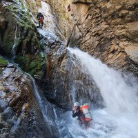
Wenn der Wasserstand ok ist und der erste Abseiler absolviert wurde, folgt nach einem kurzen Gehgelände der wirklich sensationelle Teil der Schlucht. Es folgt Abseilstelle auf Abseilstelle, durch teilweise sehr turbulente und tiefe Gumpen. Die Schlucht wurde bei der Begehung am 2.6.2019 im Zuge eine Fortbildung der Kärntner Schluchtenführer so eingerichtet, dass praktisch alle gefährlicheren Gumpen mit Seilbahnen umgangen werden können. Es empfiehlt sich jedoch gerade für die Person, die als erstes abseilen und etwaige Seilbahnen aufbauen, dass diese Wildwassererfahrung haben. Bei einigen Stellen in der Schlucht befinden sich auch Bohrhaken für den Aufbau von Seilgeländer, die zur Abseilstelle führen.
Die Schlucht besticht nicht durch ihre hohen Abseiler, sondern durch ihre Aquatik!
Once you have reached the streambed, you follow it for about 150m before you come to the first rappel. The tour is in no way to be underestimated, as it carries quite a bit of water. During the tour there is practically no chance to get off. If the water level is critical at the first rappel, it is recommended to turn back! Also, the weather situation must be closely observed during the ascent, as the catchment area of the Ochsenschlucht is very large!
If the water level is ok and the first rappel has been completed, the really sensational part of the canyon follows after a short walking terrain. Abseil point follows abseil point, through partly very turbulent and deep pools. The canyon was set up during the inspection on 2.6.2019 in the course of an advanced training of the Carinthian canyon guides so that virtually all dangerous pools can be bypassed with cable cars. However, it is recommended, especially for the person who will be the first to rappel and set up any ropeways, that they have white water experience. In some places in the canyons, there are also pitons for setting up rope traverses leading to the rappelling point.
The canyon is not impressive for its high rappel, but for its aquatic!
Retour (0 min):
traduction alternative
➜
Langue originale
Bei ca 700Hm hat man dann den letzten Abseiler absolviert. Es folgt eine ca 30-minütiger Gehstrecke und Blockhüpferrei in einer sensationellen landschaftlichen Kulisse durch eine Engklamm! Wenn sich die Schlucht zunehmend öffnet kommt man zur Wehranlage, wo man vorher die Wasserstandskontrolle durchgeführt hat. Hier führt or. rechts ein Weg runter, den man für weitere ca 5 min folgt. Man kommt direkt beim Parkplatz raus an dem die Autos abgestellt wurden.
At about 700Hm you have then completed the last rappel. This is followed by about 30 minutes of walking passages and block hopping in a sensational scenic backdrop through a gorge! When the canyon opens up more and more, you come to the weir, where you have previously checked the water level. Here leads or. right a way down, which one follows for further approx. 5 min. You come out directly at the parking lot where the cars were parked.
Coordonnées:
Départ du Canyon
46.7136°, 13.125°
↓↑
DMS: 46° 42" 48.96', 13° 7" 30'
DM: 46° 42.816", 13° 7.5"
Google Maps
Autriche Topographique
DMS: 46° 42" 48.96', 13° 7" 30'
DM: 46° 42.816", 13° 7.5"
Google Maps
Autriche Topographique
Parking à la sortie
46.7326°, 13.123°
↓↑
DMS: 46° 43" 57.36', 13° 7" 22.8'
DM: 46° 43.956", 13° 7.38"
Google Maps
Autriche Topographique
DMS: 46° 43" 57.36', 13° 7" 22.8'
DM: 46° 43.956", 13° 7.38"
Google Maps
Autriche Topographique
Fin du Canyon
46.7289°, 13.128°
↓↑
DMS: 46° 43" 44.04', 13° 7" 40.8'
DM: 46° 43.734", 13° 7.68"
Google Maps
Autriche Topographique
DMS: 46° 43" 44.04', 13° 7" 40.8'
DM: 46° 43.734", 13° 7.68"
Google Maps
Autriche Topographique
Info canyon ACA
Info canyon Cwiki
Info canyon Descente
Autre info canyon
25.04.2023
System User
⭐
★★★★★
📖
★★★
⚓
★★★
pas de traduction disponible
Der aktuelle Canyon wurde teilautomatisiert mit Canyon https://canyon.carto.net/cwiki/bin/view/Canyons/OchsenschluchtCanyon.html zusammengeführt.
09.03.2023
System User
⭐
★★★★★
📖
★★★
⚓
★★★
pas de traduction disponible
Daten importiert von https://canyon.carto.net/cwiki/bin/view/Canyons/OchsenschluchtCanyon.html
09.03.2023
System User
⭐
★★★★★
📖
★★★
⚓
★★★
pas de traduction disponible
Daten importiert von https://www.canyoning.or.at/index.php/liste-aller-canyons/475-ochsenschlucht
Hydrologie:
