v2 a3 III
2h10
35min
1h30
5min
670m
600m
70m
20m
1x40m
7
1000m
à pied
Évaluation:
★★★★★
3.5 (10)
Info:
★★★
2.6 (7)
Belay:
★★★
2.6 (8)
Résumé:
traduction alternative
➜
Langue originale
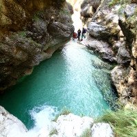
Schöne kurze aquatische Kalkschlucht; einige Sprung- und Rutschmöglichkeiten; frisches sauberes Wasser; Süd-Westliche Ausrichtung; kombinierbar mit Rio Lomming.
Beautiful short aquatic lime canyon; some jumping and slides; fresh clean water; southwest exposure; can be combined with Rio Lomming.
Sud
Résumé:
traduction alternative
➜
Langue originale
Schöne kurze aquatische Kalkschlucht; einige Sprung- und Rutschmöglichkeiten; frisches sauberes Wasser; Süd-Westliche Ausrichtung; kombinierbar mit Rio Lomming.
Beautiful short aquatic lime canyon; some jumping and slides; fresh clean water; southwest exposure; can be combined with Rio Lomming.
Accès:
traduction alternative
➜
Langue originale
Zwischen Chiusaforte und Carnia liegt die Ortschaft Resuitta. Von hier fährt man ins schöne Resia Tal. Man folgt dem Straßenverlauf mit der Beschilderung „Stolvizza“ und „Coritis“. Nach der Ortschaft Stolvizza führt die Straße zuerst nach unten. Man überquert den T. Resia (Beschilderung „Coritis“ folgen). Danach kommen einige enge Serpentinen bergauf bis zu einer Kapelle. Ab hier führt die Straße wieder leicht bergab. Ab der Kapelle überquert man nach ca. 2,2Km zwei kleine kurz aufeinander folgende Straßenbrücken (R. Slatina und T. Resia). Hier gleich nach der zweiten Brücke li abwärts der Forststraße für 400m bis ganz nach hinten folgen (Achtung! Man überquert 2 Bachüberfuhren und benötigt daher etwas Bodenfreiheit!). Am Schluss (nach der 2. Überfuhr) macht die Forststraße eine Rechtskurve. Entweder Parkt man das Auto hier oder man folgt der Fortstraße noch ca. 100m nach oben und parkt das Auto direkt bei der Wanderwegtafel 657 (Ein-/Ausstiegsparkplatz).
(P.s. Von der Tafel Ortsende Resiutta bis Stolvizza sind es 9Km und von Stolvizza bis zu den zwei kleinen Brücken sind es 4,4Km.)
about 30min.
Between Chiusaforte and Carnia is the village of Resuitta. From here you drive into the beautiful Resia Valley. Follow the road with the signs "Stolvizza" and "Coritis". After the village of Stolvizza, the road first goes down. One crosses the T. Resia (follow the signs "Coritis"). Then there are some narrow serpentines uphill until you reach a chapel. From here the road goes slightly downhill again. From the chapel, after about 2.2 km, you will cross two small road bridges (R. Slatina and T. Resia). Here, immediately after the second bridge, follow the forest road on the left downhill for 400m to the very back (Attention! One crosses 2 stream crossings and therefore needs some ground clearance!). At the end (after the 2nd crossing) the forest road makes a right turn. Either park the car here or follow the forest road upwards for about 100m and park the car directly at the hiking trail sign 657 (entry/exit parking exit).
(P.s. From the sign at the end of Resiutta to Stolvizza it is 9 km and from Stolvizza to the two small bridges it is 4.4 km).
Approche (35 min):
traduction alternative
➜
Langue originale
Vom Parkplatz direkt bei der Wanderbeschilderung 657 („Birio Sant“, „Sella Grubia“)den Weg orografisch rechts neben dem Bach folgen. Bei der Holztafel mit abgebildetem Vogel, führt der Wanderweg nach oben. Diesen ca. 140Hm folgen bis re ein unscheinbarer Pfad abzweigt (markanter Weg geht nach li. Rechts ist ein trockenes Bachbett). Man folgt dem Steig neben der Klamm bis zu einem Schotterhang (2 rote Punkte). Dann den steilen Schotterhang über rote Punkte bis ins Bachbett folgen/absteigen. Einstieg auf ca. 670m.
about 30-40min.
From the parking lot, directly at the hiking sign 657 ("Birio Sant", "Sella Grubia"), follow the orographic path to the right of the stream. At the wooden board with the bird on it, the path goes up. Follow it for about 140m until an inconspicuous path branches off to the right (marked path goes to the left. On the right is a dry streambed). Follow the path next to the gorge until you reach a gravel slope (2 red dots). Then follow/descend the steep gravel slope via red dots to the streambed. Entry at approx. 670m.
Tour (1 h 30):
traduction alternative
➜
Langue originale
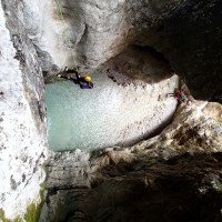
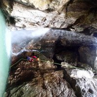
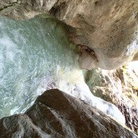
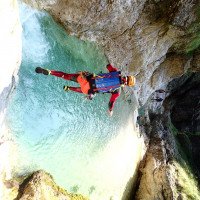
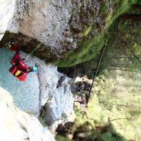
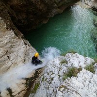
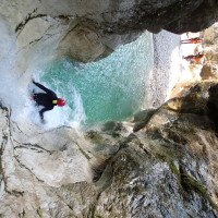
Der Zustieg ist nicht ganz leicht und verhältnismäßig zu Tour eher lang. Trotzdem ist der Rio Ronc eine lohnenswerte Schlucht. Gerade Jene die gerne rutschen und springen werden auf ihr Kosten kommen. Nach einem kurzen Gehabschnitt kommen schon die ersten 2 Abseilstellen; 3m und 20m. Die 20m Stufe ist auch schon die höchste Stelle. Die meisten der darauffolgenden Stufen können je nach Wasserstand gerutscht oder gesprungen werden. Zwischen den Stufen hat man immer wieder kurze Gehpassagen mit schönen Auswaschungen. Die Tour endet am Zustiegsweg auf ca. 600m.
about 1,5h
The access is not easy and rather long in relation to the tour. Nevertheless, the Rio Ronc is a worthwhile canyons. Especially those who like to slide and jump will get their money's worth. After a short walking section come the first 2 abseils; 3m and 20m. The 20m step is also the highest point. Most of the following steps can be slid or jumped, depending on the water level. Between the steps there are always short walking passages with nice washouts. The tour ends at the access path at about 600m.
Retour (5 min):
traduction alternative
➜
Langue originale
Rechts aus dem Bach auf den Zustiegsweg aufsteigen und in Kürze zurück zum Parkplatz.
About 5min
Climb right out of the creek onto the access path and shortly back to the parking lot.
Coordonnées:
Départ du Canyon
Parking à l'entrée et à la sortie
Parkmöglichkeit direkt an der Bachmündung (cwiki)
Fin du Canyon
Info canyon ACA
Info canyon Cwiki
Info canyon Descente
Info canyon Ropewiki
03.08.2024
Thomas Fras
⭐
★★★★★
📖
★★★
⚓
★★★
💧
Normale
Terminé ✔
traduction alternative
➜
Langue originale
29.07.2024
Kubik125
⭐
★★★★★
📖
★★★
⚓
★★★
💧
Normale
Terminé ✔
pas de traduction disponible
Automatisch importiert von Descente-Canyon.com für Canyon Ronc
Good conditions. Deep pools. Jumping opportunities.
(Quelle: https://www.descente-canyon.com/canyoning/canyon-debit/23462/observations.html)
15.07.2024
Fimbi
⭐
★★★★★
📖
★★★
⚓
★★★
💧
Faible
Terminé ✔
traduction alternative
➜
Langue originale
2te oder dritte Abseilstelle war nicht vorhanden. Ein Sprung war nicht möglich, da von oben zu seicht. Wir haben uns am eingeklemmten Baum abgeseilt. Sollte der mal nicht da sein, kann über den gesamten Felsblock das Seil gelegt werden. Ansonst super schön und tolle Sprung Möglichkeiten.
There was no 2nd or third abseil point. A jump was not possible as it was too shallow from above. We rappelled down the trapped tree. If it is not there, the ropes can be laid over the entire boulder. Otherwise superiore beautiful and great jumping opportunities.
14.07.2024
Marosffy Dániel
⭐
★★★★★
📖
★★★
⚓
★★★
💧
Normale
Terminé ✔
pas de traduction disponible
Rope is only required for the first 2 rappels, otherwise everything can be jumped or slid. All pools are clear.
25.06.2024
Bernhard
⭐
★★★★★
📖
★★★
⚓
★★★
💧
Normale
Terminé ✔
traduction alternative
➜
Langue originale
Lustiger kurzer Spaß Canyon mit hoher Rutsche und hohen Sprüngen
Fun short fun canyon with high slide and high jumps
25.06.2024
Bernhard
⭐
★★★★★
📖
★★★
⚓
★★★
💧
Normale
Terminé ✔
traduction alternative
➜
Langue originale
Erste Hälfte unlohnend
Sprünge und die hohe Rutsche super
Wasserstand normal und problemlos
Eben ein reiner schneller Spaß Canyon
First half unrewarding
Jumps and the high slide superiore
Water level normal and problem-free
Just a pure fast fun canyon
08.06.2024
Andi Schober
⭐
★★★★★
📖
★★★
⚓
★★★
💧
Haut
Terminé ✔
traduction alternative
➜
Langue originale
Wasserstand hoch aber kein Problem. Rutschen und Sprünge machbar. Zustieg am Ende etwas mit Geröll verlegt aber gut gangbar.
High water level but no problem. Slides and jumps doable. Access at the exit is somewhat scree-covered but easy to negotiate.
06.07.2023
Martin Jasek
⭐
★★★★★
📖
★★★
⚓
★★★
💧
Normale
Terminé ✔
pas de traduction disponible
One dry rappelling and continue with aquatic adventure full of jumps, nice but really short, we did it from car to car in 70 minutes.
21.05.2023
Thomas Fras
⭐
★★★★★
📖
★★★
⚓
★★★
💧
Normale
Terminé ✔
traduction alternative
➜
Langue originale
Wie gewohnt schöne kurze aquatischen Tour, alles Top
As usual nice short aquatic tour, everything top
09.03.2023
System User
⭐
★★★★★
📖
★★★
⚓
★★★
pas de traduction disponible
Info: Teile der Canyonbeschreibung wurden automatisiert übernommen. Konkret die Felder Weblinks, Koordinaten, Rating, Ort, Länge des Canyon, Einfachseil Mindestens von https://canyon.carto.net/cwiki/bin/view/Canyons/RioRoncCanyon.html und https://www.descente-canyon.com/canyoning/canyon/23462
09.03.2023
System User
⭐
★★★★★
📖
★★★
⚓
★★★
pas de traduction disponible
Daten importiert von https://www.canyoning.or.at/index.php/liste-aller-canyons/403-rio-ronc
Nouveau rapport
Veuillez décrire brièvement et de manière concise les informations les plus importantes de la dernière visite ou les informations actuelles importantes sur le canyon. Si nécessaire avec des liens vers des vidéos, photos, etc.
*
*
*
Esc
Del
Hydrologie:

