difficile
Rudach
v5 a3 IV
2h15
5min
1h30
40min
930m
770m
160m
65m
2x 70m
7
300m
à pied
Évaluation:
★★★★★
4.1 (9)
Info:
★★★
2.9 (6)
Belay:
★★★
2.9 (8)
Résumé:
traduction alternative
➜
Langue originale
Abseilcanyon
rappel canyon
Nord
Résumé:
traduction alternative
➜
Langue originale
Abseilcanyon
rappel canyon
Accès:
traduction alternative
➜
Langue originale
Zunächst zum oberen Parkplatz für den Zustieg in die Kobelache (vgl. dort); dann weiter die Forststraße an der Kobelache entlang aufwärts. Dabei queren wir 3-mal deren Bachbett. Unmittelbar vor der 4. Brücke (ca. 1,5 km ab Parkplatz Kobelache) nehmen wir die links (ostwärts) abzweigende Piste. Erneut queren wir 2-mal Bäche (das 2. Mal in einer scharfen Linkskurve). Von unserem nun in nördlicher Richtung bergauf führenden Forstweg sehen wir auf die links unterhalb gelegene Kobelalpe und erreichen kurz danach in einer Rechtskurve eine kleine Hochfläche. Hier können wir das Auto abstellen.
First to the upper parking lot for the access to the Kobelache (see there); then further up the forest road along the Kobelache. We cross its streambed 3 times. Immediately before the 4th bridge (approx. 1.5 km from the Kobelache parking lot) we take the track branching off to the left (eastward). Again we cross streams 2 times (the 2nd time in a sharp left turn). From our forest road, which now leads uphill in a northerly direction, we can see the Kobelalpe, which is located on the left below, and shortly afterwards we reach a small plateau in a right-hand bend. Here we can park the car.
Approche (5 min):
traduction alternative
➜
Langue originale
Von der erwähnten Rechtskurve folgen wir der Forststraße noch ca. 40m in östlicher Richtung, bevor wir dann weglos links hinunter (nordwärts) in das Bachbett der Rudach absteigen.
From the aforementioned right turn, we follow the forest road for about 40m in an easterly direction before we descend pathlessly to the left (northwards) into the streambed of the Rudach.
Tour (1 h 30):
traduction alternative
➜
Langue originale
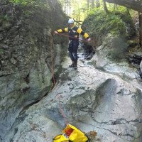
Nach wenigen Metern im Bachbett folgen einige kleinere Stufen (bei der ersten Stufe, die man auch abklettern kann, Haken etwas versteckt in einer bachabwärts gerichteten Wölbung), bevor wir einen höheren Abbruch erreichen (ca. 40m). Diesen seilen wir in zwei Abschnitten ab. Es folgt ein Abseiler von ca. 20m; wenn man über den eingeklemmten Wurzelstrunk seilt, kann man sich weitgehend aus dem Strahl heraushalten. Nach einem weiteren Abseiler (ca.14m) nehmen wir den Handlauf zum Stand über der C65. In dieser nun unter uns liegenden Wand hat es schon einen Zwischenstand gegeben, aber man sollte sich nicht darauf verlassen, da der Abseiler (in Fallinie) im Einzugsbereich des Strahls (wenn auch an dessen Rand) legt, wenn das Frühjahrshochwasser hinunterdonnert.
After a few meters in the streambed follow some smaller steps (at the first step, which can also be downclimbed, anchor somewhat hidden in a downstream bulge), before we reach a higher drop (about 40m). We rappel this in two parts. A rappel of about 20m follows; if you rappel over the trapped root stump, you can largely stay out of the stream. After another rappel (ca.14m) we take the handrail to the belaystation above the C64. In this wall, which is now below us, there has already been an intermediate stand, but one should not rely on it, since the rappel (in fall line) lays in the catchment area of the rappel (albeit at its edge) when the spring flood thunders down.
Retour (40 min):
traduction alternative
➜
Langue originale
Nach dem abschließenden hohen Wasserfall in einem weiten Bogen weglos in westlicher Richtung aufwärts. Wenige Meter unterhalb des Grates erreichen wir einen Wanderweg, der uns am Rande der großen Wiese entlang, vorbei an der Kobelalpe, hinauf zum geparkten Auto führt.
After the final high waterfall in a wide arc pathless uphill in a westerly direction. A few meters below the ridge we reach a hiking trail that leads us along the edge of the large meadow, past the Kobelalpe, up to the parked car.
Coordonnées:
Départ du Canyon
47.3661°, 9.79124°
↓↑
DMS: 47° 21" 57.96', 9° 47" 28.46'
DM: 47° 21.966", 9° 47.474"
Google Maps
Autriche Topographique
DMS: 47° 21" 57.96', 9° 47" 28.46'
DM: 47° 21.966", 9° 47.474"
Google Maps
Autriche Topographique
Fin du Canyon
47.3684°, 9.79°
↓↑
DMS: 47° 22" 6.24', 9° 47" 24'
DM: 47° 22.104", 9° 47.4"
Google Maps
Autriche Topographique
DMS: 47° 22" 6.24', 9° 47" 24'
DM: 47° 22.104", 9° 47.4"
Google Maps
Autriche Topographique
Parking à l'entrée et à la sortie
47.36585°, 9.7912°
↓↑
DMS: 47° 21" 57.06', 9° 47" 28.32'
DM: 47° 21.951", 9° 47.472"
Google Maps
Autriche Topographique
DMS: 47° 21" 57.06', 9° 47" 28.32'
DM: 47° 21.951", 9° 47.472"
Google Maps
Autriche Topographique
Littérature:
Carte
Carte
1:50000
Livre Canyoning
Stéphane Coté / Caracal et les Sancho Panza
2009
Info canyon Cwiki
Info canyon Descente
Info canyon Schlucht.ch
Info canyon Ropewiki
12.04.2025
Kris Klein
⭐
★★★★★
📖
★★★
⚓
★★★
💧
Normale
Terminé ✔
traduction alternative
➜
Langue originale
Die ersten Meter nach dem Einstieg (1. Abseiler) aufgrund von Baumfällarbeiten recht viel frisches Holz/Baumstämme in der Schlucht. Stände alle i. O.
The first few meters after entry (1st rappel) quite a lot of fresh wood/tree trunks in the canyon due to tree felling work. Stands all ok.
15.10.2024
Matthias Holzinger
⭐
★★★★★
📖
★★★
⚓
★★★
pas de traduction disponible
Automatisch importiert von Schlucht.ch für Canyon Rudach (Vorarlberg), Wasserstand: "hoch" Verankerungen: "sehr gut"
Alles tip-top
(Quelle: https://schlucht.ch/schluchten-der-schweiz-liste/1159-rudach-vorarlberg)
15.10.2024
Matthias Holzinger
⭐
★★★★★
📖
★★★
⚓
★★★
💧
Haut
Terminé ✔
traduction alternative
➜
Langue originale
Alles tip-top, sehr schöner Wasserstand
Everything tip-top, very nice water level
15.08.2024
Gregor Bernsteiner
⭐
★★★★★
📖
★★★
⚓
★★★
💧
Faible
Terminé ✔
traduction alternative
➜
Langue originale
Alles Top 👍
Everything top 👍
11.08.2024
Gaechter Michael
⭐
★★★★★
📖
★★★
⚓
★★★
💧
Faible
Terminé ✔
traduction alternative
➜
Langue originale
Sehr wenig Wasser , alle Verankerung io
Very little water , all anchoring io
10.08.2024
Mitch
⭐
★★★★★
📖
★★★
⚓
★★★
💧
Faible
Terminé ✔
traduction alternative
➜
Langue originale
Alles gut. Etwas rutschig
All good. A little slippery
06.07.2024
Sallemann
⭐
★★★★★
📖
★★★
⚓
★★★
💧
Normale
Terminé ✔
pas de traduction disponible
Automatisch importiert von Descente-Canyon.com für Canyon Rudach
bachab-Kurs-Schlucht am heutigen Tag; Stände alle tiptop, griffig zu gehen.
(Quelle: https://www.descente-canyon.com/canyoning/canyon-debit/21863/observations.html)
06.07.2024
Gächter
⭐
★★★★★
📖
★★★
⚓
★★★
pas de traduction disponible
Automatisch importiert von Schlucht.ch für Canyon Rudach (Vorarlberg), Wasserstand: "mittel" Verankerungen: "sehr gut "
ein wenig rutschig
(Quelle: https://schlucht.ch/?view=article&id=1159&Itemid=203)
06.07.2024
Inga
⭐
★★★★★
📖
★★★
⚓
★★★
💧
Normale
Terminé ✔
traduction alternative
➜
Langue originale
D'autres utilisateurs ont été: Simone Steffke Sarah Allemann Silvan marc sparklefarts
Klein aber fein, etwas ruschig heute
Small but nice, a little rough today
D'autres utilisateurs ont été: Simone Steffke Sarah Allemann Silvan marc sparklefarts
15.08.2023
Sascha Schäfer
⭐
★★★★★
📖
★★★
⚓
★★★
💧
Normale
Terminé ✔
traduction alternative
➜
Langue originale
alles tip top- geklebte U Anker - am C65m eine Kette- für komerzielle Begehung ausgerüstet
everything tip top - glued U anchors - at the C65m a chain - equipped for commercial climbing
09.03.2023
System User
⭐
★★★★★
📖
★★★
⚓
★★★
pas de traduction disponible
Info: Teile der Canyonbeschreibung wurden automatisiert übernommen. Konkret die Felder Weblinks, Koordinaten, Rating, Länge des Canyon, Einfachseil Mindestens von https://www.descente-canyon.com/canyoning/canyon/21863
09.03.2023
System User
⭐
★★★★★
📖
★★★
⚓
★★★
pas de traduction disponible
Daten importiert von https://canyon.carto.net/cwiki/bin/view/Canyons/RudachCanyon.html
28.08.2022
Bubtore
⭐
★★★★★
📖
★★★
⚓
★★★
💧
Normale
Terminé ✔
traduction alternative
➜
Langue originale
Schöne Tour, zusammen mit Kobelache gemacht.
Nice tour, done together with Kobelache.
Nouveau rapport
Veuillez décrire brièvement et de manière concise les informations les plus importantes de la dernière visite ou les informations actuelles importantes sur le canyon. Si nécessaire avec des liens vers des vidéos, photos, etc.
*
*
*
Esc
Del
Hydrologie:
traduction alternative
➜
Langue originale
https://vowis.vorarlberg.at/stationsInfo/tbl_Abflussstationen.aspx
https://vowis.vorarlberg.at/stationsInfo/tbl_Abflussstationen.aspx