v4 a5 IV
4h15
5min
4h
10min
910m
630m
280m
24m
3x30m
28
800m
Voiture obligatoire
Évaluation:
★★★★★
4 (6)
Info:
★★★
2.3 (3)
Belay:
★★★
2.3 (4)
Résumé:
traduction alternative
➜
Langue originale
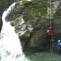
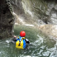
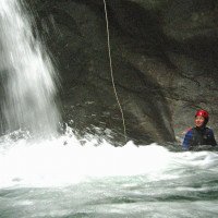
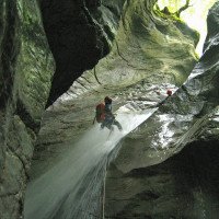
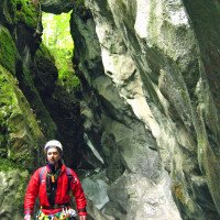
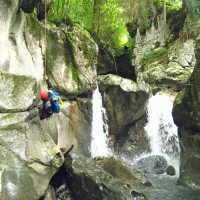
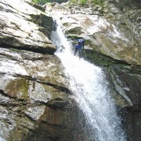
Aquatischer Abseilcanyon; kaltes Wasser mit meist großer Wucht; schöne Formationen; relativ eng geschnitten, keine hohen Seitenwände, aber trotzdem nur jeweils ein Notausstieg im oberen und unteren Abschnitt möglich; aber Aus- und Zustieg bei der Straßenbrücke möglich, die die Schlucht etwa in der Mitte (710m üNN) überspannt. Unterer Teil einfacher (hier höchster Abseiler 18m).
Aquatic rappel canyon; cold water with mostly great force; beautiful formations; relatively narrow, no high side walls, but still only one emergency exit possible in each of the upper and lower parts; but exit and access possible at the road bridge that spans the canyon approximately in the middle (710m above sea level). Lower section easier (here highest rappel 18m).
Nord
Résumé:
traduction alternative
➜
Langue originale
Aquatischer Abseilcanyon; kaltes Wasser mit meist großer Wucht; schöne Formationen; relativ eng geschnitten, keine hohen Seitenwände, aber trotzdem nur jeweils ein Notausstieg im oberen und unteren Abschnitt möglich; aber Aus- und Zustieg bei der Straßenbrücke möglich, die die Schlucht etwa in der Mitte (710m üNN) überspannt. Unterer Teil einfacher (hier höchster Abseiler 18m).
Aquatic rappel canyon; cold water with mostly great force; beautiful formations; relatively narrow, no high side walls, but still only one emergency exit possible in each of the upper and lower parts; but exit and access possible at the road bridge that spans the canyon approximately in the middle (710m above sea level). Lower section easier (here highest rappel 18m).
Accès:
traduction alternative
➜
Langue originale
Von der östlich des Vierwaldstättersees gelegenen Ortschaft Schwyz (im gleichnamigen Kanton) fahren wir die Muota entlang aufwärts nach Muotathal. Wir durchqueren die Ortschaft und kommen an ihrem Ende in den Ortsteil Hinterthal. Hier knickt die Straße in eine scharfen Linkskurve und überquert die Muota. Wir fahren aber vor der Brücke geradeaus (linkerhand am Bach ein Gasthof) und stellen hier an geeigneter Stelle das untere Auto ab.\n\nMit dem zweiten fahren wir am Gasthof rechts in Richtung "Hürital". Die kräftig ansteigende Straße quert in Höhe 730m üNN den Hüribach, zieht in einer langgezogenen Serpentine weiter aufwärts, um erneut den Hüribach zu queren. Hier parken wir das zweite Auto.\n\nSofern man nur 1 Auto zur Verfügung hat, nimmt man den Wanderweg, der auf der orograf. re. Seite des Hüribaches aufwärts führt (ca. 1 Std.).
From the village of Schwyz (in the canton of the same name) to the east of Lake Lucerne, we ride uphill along the Muota to Muotathal. We cross the village and reach the district of Hinterthal at its exit. Here the road bends sharply to the left and crosses the Muota. However, we drive straight ahead before the bridge (an inn on the left-hand side of the stream) and park the lower car in a suitable place.\n\nWith the second car, we turn right at the inn in the direction of "Hürital". The steeply ascending road crosses the Hüribach at 730m above sea level, continues uphill in a long serpentine to cross the Hüribach again. Park the second car here.\n\nIf you only have 1 car available, take the hiking trail that leads up the orographic right side of the Hüribach (approx. 1 hour).
Approche (5 min):
traduction alternative
➜
Langue originale
Unmittelbar von der Brücke.
Directly from the bridge.
Tour (4 h):
traduction alternative
➜
Langue originale
Die im Topo ausgewiesenen Sprunggumpen können aufgekiest sein, also sorgfältig prüfen! Nach dem Frühjahrshochwasser können auch Haken beschädigt sein oder herausgeschlagen. Es kann aber auch vorkommen, dass (wie im zB auch im Zanaibach) Felsen unter dem Haken weggespült sind und so der Haken nicht mehr bzw nur unter Schwierigkeiten erreichbar ist.\n\nDie angegebene Zeit für den Abstieg in der Schlucht kann sich je nach Wasserstand bis auf etwa 2,5 Std. reduzieren.
The jump pools shown in the topographic view may be gravelled, so check carefully! After the spring floods, anchors may also be damaged or knocked out. However, it can also happen that (as in the Zanaibach, for example) rocks under the anchor are washed away and the anchor is no longer accessible or only accessible with difficulty.\n\nThe time given for the descent in the canyon can be reduced to about 2.5 hours depending on the water level.
Retour (10 min):
traduction alternative
➜
Langue originale
Vor Erreichen der Häuser rechts hinaus und über die Wiese zum unteren Auto.
Before reaching the houses, turn right and cross the meadow to the car below.
Coordonnées:
Fin du Canyon
46.9713°, 8.7728°
↓↑
DMS: 46° 58" 16.68', 8° 46" 22.08'
DM: 46° 58.278", 8° 46.368"
Google Maps
Suisse Topographique
DMS: 46° 58" 16.68', 8° 46" 22.08'
DM: 46° 58.278", 8° 46.368"
Google Maps
Suisse Topographique
Départ du Canyon
46.9637°, 8.77361°
↓↑
DMS: 46° 57" 49.32', 8° 46" 25'
DM: 46° 57.822", 8° 46.417"
Google Maps
Suisse Topographique
DMS: 46° 57" 49.32', 8° 46" 25'
DM: 46° 57.822", 8° 46.417"
Google Maps
Suisse Topographique
(descente_1)
Parking à l'entrée
46.9637°, 8.77344°
↓↑
DMS: 46° 57" 49.32', 8° 46" 24.38'
DM: 46° 57.822", 8° 46.406"
Google Maps
Suisse Topographique
DMS: 46° 57" 49.32', 8° 46" 24.38'
DM: 46° 57.822", 8° 46.406"
Google Maps
Suisse Topographique
(descente_3)
Parking à la sortie
46.9731°, 8.77366°
↓↑
DMS: 46° 58" 23.16', 8° 46" 25.18'
DM: 46° 58.386", 8° 46.42"
Google Maps
Suisse Topographique
DMS: 46° 58" 23.16', 8° 46" 25.18'
DM: 46° 58.386", 8° 46.42"
Google Maps
Suisse Topographique
(descente_4)
Sortie intermédiaire du canyon
46.9686°, 8.77394°
↓↑
DMS: 46° 58" 6.96', 8° 46" 26.18'
DM: 46° 58.116", 8° 46.436"
Google Maps
Suisse Topographique
DMS: 46° 58" 6.96', 8° 46" 26.18'
DM: 46° 58.116", 8° 46.436"
Google Maps
Suisse Topographique
echappatoire ou deuxieme entrée (descente)
Littérature:
Carte
1:25000
Carte
1:25000
Livre Canyoning
Emmanuel Belut / Laurence Boyé / Thomas Guigon
Association Openbach
2015
9782746679450
Livre Canyoning
F. Baumgartner / A. Brunner / D. Zimmermann
2010
Livre Canyoning
Stéphane Coté / Caracal et les Sancho Panza
2007
124 Canyon-Beschreibungen
Info canyon Cwiki
Info canyon Descente
Info canyon Ropewiki
Info canyon Schlucht.ch
Carte
07.09.2024
fiumicicoli
⭐
★★★★★
📖
★★★
⚓
★★★
💧
Normale
Terminé ✔
pas de traduction disponible
Automatisch importiert von Descente-Canyon.com für Canyon Hüribach
L’équipement est devenu vraiment limite! mérite un rééquipement
(Quelle: https://www.descente-canyon.com/canyoning/canyon-debit/21334/observations.html)
24.08.2024
Inga
⭐
★★★★★
📖
★★★
⚓
★★★
pas de traduction disponible
Automatisch importiert von Schlucht.ch für Canyon Hüribach, Wasserstand: "Debit correct" Verankerungen: "Alt, aber i.O."
Teilweise super rutschig zu gehen und überraschend kalt
(Quelle: https://schlucht.ch/schluchten-der-schweiz-liste/1055-hueribach)
24.08.2024
SimoneSt
⭐
★★★★★
📖
★★★
⚓
★★★
💧
Normale
Terminé ✔
pas de traduction disponible
Automatisch importiert von Descente-Canyon.com für Canyon Hüribach
Amarages correct, souvent en double avec chaine. Parfois caché sous la mousse ;-) Dans la partie inférieure au C9 (?) il y a un qui est presque inaccessible (RD, en haut, grimpe risqué sur une crête , positionné dans un creux derrière la crête) qu'on devrait placer ailleurs. Assez glissant, surtout hors de l'eau.Sinon, magnifique canyon ! Contact très gentil avec la centrale électrique. Demandez qu'ils arrêtent le mechanisme automatique. Attention : pour le parking amont ne laisser pas les voitures directement au pont. L'espace libre à côté de la rue est nécessaire pour la circulation (l'esquive). Il y a une grande place (bûcherons) 200 m plus haut à gauche.
(Quelle: https://www.descente-canyon.com/canyoning/canyon-debit/21334/observations.html)
24.08.2024
Juan Montesinos
⭐
★★★★★
📖
★★★
⚓
★★★
💧
Normale
Terminé ✕
traduction alternative
➜
Langue originale
Barranco resbaladizo, todas las reuniones en orden. Muchas son dobles con cadena y eslabón libre, aunque están empezando a quedarse viejas.
Slippery gully, all meetings in order. Many are doubles with chain and free link, although they are starting to get old.
24.08.2024
Inga
⭐
★★★★★
📖
★★★
⚓
★★★
💧
Normale
Terminé ✔
traduction alternative
➜
Langue originale
D'autres utilisateurs ont été: Simone Steffke Juan Montesinos
Top Wasserstand, im aktiv meist recht griffig zu gehen, außerhalb sehr rutschig. Anker alt, aber ok. Einige Fixseile könnten ausgetauscht werden.
Top water level, usually quite easy to walk in the active part, very slippery outside. Anchor old, but ok. Some fixed ropes could be replaced.
D'autres utilisateurs ont été: Simone Steffke Juan Montesinos
25.06.2023
Nico Schneider
⭐
★★★★★
📖
★★★
⚓
★★★
💧
Normale
Terminé ✔
traduction alternative
➜
Langue originale

Der Bach ist sehr rutschig, aber er sollte auf jeden Fall gemacht werden, wenn man in der Nähe ist. Mit Abstand der schönste und kontinuierlichste Bach in der Umgebung.
Bild vom Wasserstand ist angehängt.
Das Bild wurde an der Wasserfassung bei der mittleren Brücke aufgenommen.
The creek is very slippery, but it should definitely be done if you are in the area. By far the most beautiful and continuous stream in the area.
Picture of the water level is attached.
The picture was taken at the water intake by the middle bridge.
09.03.2023
System User
⭐
★★★★★
📖
★★★
⚓
★★★
pas de traduction disponible
Info: Teile der Canyonbeschreibung wurden automatisiert übernommen. Konkret die Felder Weblinks, Koordinaten, Rating, Länge des Canyon, Einfachseil Mindestens von https://www.descente-canyon.com/canyoning/canyon/21334
09.03.2023
System User
⭐
★★★★★
📖
★★★
⚓
★★★
pas de traduction disponible
Daten importiert von https://canyon.carto.net/cwiki/bin/view/Canyons/HueribachCanyon.html
Nouveau rapport
Veuillez décrire brièvement et de manière concise les informations les plus importantes de la dernière visite ou les informations actuelles importantes sur le canyon. Si nécessaire avec des liens vers des vidéos, photos, etc.
*
*
*
Esc
Del
Hydrologie: