un peu difficile
Bodengo I (Boggia I)
v3 a4 III
1h42
2min
1h30
10min
950m
910m
40m
12m
2x20m (1x20m/1x40m)
5
Voiture facultative
Spécialités:
§ Parking payant ruisseau amusant
§ Parking payant ruisseau amusant
Évaluation:
★★★★★
4.5 (11)
Info:
★★★
2.8 (9)
Belay:
★★★
2.9 (11)
Résumé:
traduction alternative
➜
Langue originale
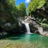
Sehr schöne Schlucht mit smaragdgrünen kalten Wasser; sehr gut eingerichtet; €5,- für private Bergstraße; 1. Teil einfach; 2. Teil mittel; 3. Teil sehr lange und anspruchsvoll (auf Wasserpegel achten!); sehr schönes und griffiges Gneiss- und Granit-Gestein, die meisten Abseiler außerhalb der Wasserführung, die Schlucht ist im gesamten jedoch sehr aquatisch!
Very beautiful canyon with emerald green cold water; very well equipped; €5,- for private mountain road; 1st part easy; 2nd part medium; 3rd part very long and challenging (watch for water level!); very nice and grippy gneiss and granite rock, most rappels outside the water flow, the canyon as a whole is however very aquatic!
Webcam with water level: http://www.valbodengo.com/d/phone/webcam.html
Partie
Nom
Difficulté
Approche
Tour
Retour
Est
Résumé:
traduction alternative
➜
Langue originale
Sehr schöne Schlucht mit smaragdgrünen kalten Wasser; sehr gut eingerichtet; €5,- für private Bergstraße; 1. Teil einfach; 2. Teil mittel; 3. Teil sehr lange und anspruchsvoll (auf Wasserpegel achten!); sehr schönes und griffiges Gneiss- und Granit-Gestein, die meisten Abseiler außerhalb der Wasserführung, die Schlucht ist im gesamten jedoch sehr aquatisch!
Very beautiful canyon with emerald green cold water; very well equipped; €5,- for private mountain road; 1st part easy; 2nd part medium; 3rd part very long and challenging (watch for water level!); very nice and grippy gneiss and granite rock, most rappels outside the water flow, the canyon as a whole is however very aquatic!
Webcam with water level: http://www.valbodengo.com/d/phone/webcam.html
Accès:
traduction alternative
➜
Langue originale
Bei der Ortschaft Gordona fährt man zur Kirche --> li. hinter der Kirche gibt es ein Café wo man für €5,- ein Ticket für die Privat Straße kaufen muss --> danach geht es re. bei der Kirche kurz hoch --> bei der Gabelung li. --> dann scharfe Kurve (bei Gabelung) re. hoch --> nächste Gabelung li. hoch --> Straßenverlauf folgen (Richtung Pra Prince) --> auf ca. 820Hm vor einer scharfen re. Kurve, gibt es li. einen Parkplatz --> geht man die Boggia 1u.2 parkt man hier (für Boggia I kann man das Auto in der nächste Ortschaft parken) nach ca. 50m kommt ein Motorrad Fahrverbot Schild (li.) mit Weg Beschilderung Mulattiera per Bodengo und Strada Carrozzabile per Bodengo (dies ist der Weg wo man von der Brücke hochkommt/ Rückweg).
At the village Gordona you drive to the church --> left behind the church there is a café where you have to buy a ticket for the private road for €5,- --> after that you go right at the church briefly up --> at the fork left --> then sharp bend (at fork) right up --> next fork left up --> follow the road (direction Pra Prince) --> at about 820Hm before a sharp bend right, there is a parking lot left --> you go the Boggia 1u.2 park here (for Boggia I you can park the car in the next village) after about 50m there is a no motorcycle sign (left) with signs Mulattiera per Bodengo and Strada Carrozzabile per Bodengo (this is the way where you come up from the bridge / way back).
Approche (2 min):
traduction alternative
➜
Langue originale
Stoppen oder immer der Bergstraße entlang, durch die Ortschaft Pra Prince (920Hm)--> jetzt geht es noch 1 Stunde hoch bis zu einer auf der re. Seite stehenden kleinen Kapelle und li. einen Parkplatz --> hier kann man gut in den oberen Teileinsteigen (ca. 950Hm).
Stop or always along the mountain road, through the village of Pra Prince (920Hm)--> now it goes up for another 1 hour to a small chapel standing on the right side and left. a parking lot --> here you can easily get into the upper part (about 950Hm).
Tour (1 h 30):
traduction alternative
➜
Langue originale
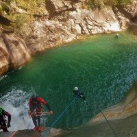
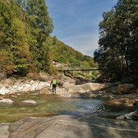
Vom Parkplatz zu den schon sichtbaren Bach absteigen -->am Anfang kleine Kletterpassagen, Sprünge und Rutschen in smaragdgrünen Wasser --> unterhalb der kleine Brücke T6 in Gumpen --> kurze R5 (li.) in kleinen Gumpen --> großer Gumpen mit Geländerseil (re.), Fixseil (re.) und Seilbahn (hier kann man von der re. Seite Springen (S6) oder über Seilbahn sich in den großen Gumpen abrutschen lassen…!!! auf Seilspannung achten) --> Geh- und Kletterpassage ca. 50m --> li. Bohrhaken mit Kettenglied R5 (li.) oder E5 --> kurze Schwimmpassage --< Geh- und Kletterpassage ca. 50m --> R6 (li.), Zugang über Geländer-seil (T6) --> Geh- und Kletterpassage ca. 100m --> nach der kurzen Gehstrecke kommt li. ein markanter nach innen gebogener Felsblock den man hintergeht und li. den Weg zur Straße nimmt (Ausstieg bei ca. 910Hm) (der Ausstieg wird deshalb gewählt um eine uninteressante Strecke auf der Straße ab zu kürzen) --> den Einstieg in den 2. Teil nimmt man nach der kleinen Berg-Ortschaft re. über die Straßenbrücke von Bedolina (ausgeschilderter Parkplatz Bedolina).
From the parking lot to the already visible stream descend -->at the beginning small climbing passages, jumps and slides in emerald green water --> below the small bridge T6 in pools --> short R5 (li.) in small pools --> large pool with traverese rope (re.), fixed rope (r.) and ropeway (here you can jump from the right side (S6) or slide down via ropeway into the big pool...!!! pay attention to rope tension) --> walking and climbing passage ca. 50m --> le. bolthook with chain link R5 (le.) or E5 --> short swimming passage --< walking and climbing passage ca. 50m --> R6 (left), access via railing rope (T6) --> walking and climbing passage ca. 100m --> after the short walking passages on the left there is a striking boulder bent inwards which you go behind and on the left you take the way to the road (exit). (the exit is chosen to shorten an uninteresting stretch on the road) --> the entry to the 2nd part is after the small mountain village on the right over the road bridge of Bedolina (signposted parking Bedolina).
Retour (10 min):
traduction alternative
➜
Langue originale
Nach der markant nach innen gebogener Felsblock li. den Weg zur Straße folgen (ca. 910Hm).
After the striking inward curved boulder left follow the path to the road (approx. 910Hm).
Coordonnées:
Départ du Canyon
Fin du Canyon
Parking à l'entrée et à la sortie
Info canyon ACA
Info canyon Cwiki
Info canyon Descente
Info canyon Ropewiki
Rapport de voyage (ex. Blogpost)
indicateur de niveau
Autre info canyon
15.09.2024
Der Insel Affe
⭐
★★★★★
📖
★★★
⚓
★★★
💧
Normale
Terminé ✔
traduction alternative
➜
Langue originale
Mega geile Schlucht! Nachsaison sehr kaltes Wasser. Nur obere Teil gegangen. Geplant Teil 2 aber durch kalte nicht gemacht.
Mega cool canyon! Very cold water in the off-season. Only did the upper part. Planned part 2 but not done due to cold.
15.09.2024
Jason Walker
⭐
★★★★★
📖
★★★
⚓
★★★
💧
Normale
Terminé ✔
pas de traduction disponible
Super nice section at normal flows. When we tried to descend earlier this year (after the massive rain) it was certainly a lot more water. Not a bad idea to have a rope to help people out of the eddy/kerwasser on the right side of the early slide!
No water spilling over the waterfall at Bodengo 3 takeout.
27.08.2024
Pepijn Hoeksema
⭐
★★★★★
📖
★★★
⚓
★★★
💧
Faible
Terminé ✔
pas de traduction disponible
We completed all three sections of Bodengo in one go. The low water level made the entire descent quite easy. It took us 8 hours from start to bottem with a team of 5 people.
The anchor points were generally in good condition, though in Bodengo 3, finding them required a bit more effort. There are also fewer anchor points in this section, which sometimes necessitates climbing down. Fortunately, the rock provides plenty of grip.
Overall, I enjoyed Bodengo 1 and 2 the most. The "Slide of Death" in Bodengo 3 was exciting, but there was also a lot of walking over large boulders, which made it a bit tedious at times.
If I had to choose between the Bodengo Integral and Bares, I would go with Bares!
05.08.2024
Norbert Fischeer
⭐
★★★★★
📖
★★★
⚓
★★★
💧
Normale
Terminé ✔
traduction alternative
➜
Langue originale
Die Seilbahn gibt es nicht mehr am großen Gumpen. Wurde abgebaut
The cable car no longer exists at the large pool. It has been dismantled
01.08.2024
Elke Osswald
⭐
★★★★★
📖
★★★
⚓
★★★
💧
Normale
Terminé ✔
traduction alternative
➜
Langue originale
Alles OK , gegen Ende des zweiten Teils im Bereich der Zufahrtstrasse (Galerie) rechts einem gelben Seilgeländer folgen wegen Arbeiten im Bach.
Everything OK, towards the exit of the second part in the area of the access road (gallery) follow a yellow rope traverse on the right due to work in the stream.
30.07.2024
Elke Osswald
⭐
★★★★★
📖
★★★
⚓
★★★
💧
Normale
Terminé ✔
traduction alternative
➜
Langue originale
Alles OK, die Seilbahn am grossen Gumpen existiert nicht mehr.
Everything is OK, the cable car at the large pool no longer exists.
04.07.2024
Urs K.
⭐
★★★★★
📖
★★★
⚓
★★★
💧
Normale
Terminé ✔
traduction alternative
➜
Langue originale
Alles super, hin und wieder rutschige Stellen.
Wasserstand siehe Foto.
Everything superiore, slippery spots now and then.
See photo for water level.
02.07.2024
Patrik
⭐
★★★★★
📖
★★★
⚓
★★★
💧
Faible
Terminé ✔
traduction alternative
➜
Langue originale
Allses i.o. Aktuell sehr gute Bedingungen.
Everything OK. Currently very good conditions.
29.06.2024
Michael Streiner
⭐
★★★★★
📖
★★★
⚓
★★★
💧
Normale
Terminé ✔
traduction alternative
➜
Langue originale
Alles gesprungen, super klares Wasser.
Everything jumped, super clear water.
22.06.2024
Jason Walker
⭐
★★★★★
📖
★★★
⚓
★★★
💧
Haut
Terminé ?
pas de traduction disponible
D'autres utilisateurs ont été: Enya Schaefer
We bailed out. The level looked fine, but made the third to fourth pitch on the topo too scary for us. We climbed back out the slab that forms the 6m slide at the start. Apparently the level was at, or above the normal commercial cut-off.
D'autres utilisateurs ont été: Enya Schaefer
03.06.2023
Wolfgang
⭐
★★★★★
📖
★★★
⚓
★★★
Terminé ✔
traduction alternative
➜
Langue originale
Begangen wie zu erwarten alles TipTop
Committed as expected everything TipTop
03.04.2023
Daniel Sturm
⭐
★★★★★
📖
★★★
⚓
★★★
Terminé ✕
traduction alternative
➜
Langue originale
Beschreibung und Koordinaten angepasst.
Description and coordinates adjusted.
09.03.2023
System User
⭐
★★★★★
📖
★★★
⚓
★★★
pas de traduction disponible
Daten importiert von https://www.canyoning.or.at/index.php/liste-aller-canyons/50-boggia-i-val-bodengo
27.09.2021
Christian Balla
⭐
★★★★★
📖
★★★
⚓
★★★
💧
Haut
Terminé ✔
traduction alternative
➜
Langue originale
Der Canyon ist sehr gut eingerichtet und verfügt über viele Notausstiege.
Tourvideo:
https://www.youtube.com/watch?v=Qj77l3PspBE
The canyon is very well equipped and has many emergency exits.
Tour video:
https://www.youtube.com/watch?v=Qj77l3PspBE
Nouveau rapport
Veuillez décrire brièvement et de manière concise les informations les plus importantes de la dernière visite ou les informations actuelles importantes sur le canyon. Si nécessaire avec des liens vers des vidéos, photos, etc.
*
*
*
Esc
Del
Hydrologie:
pas de traduction disponible
Webcam mit Wasserstand: http://www.valbodengo.com/d/phone/webcam.html
indicateur de niveau
