moins difficile
Huaxtla
v3 a3 III
4h15
30min
3h30
15min
25m
2x30 or similar
7
Voiture obligatoire
Évaluation:
★★★★★
2.5 (1)
Info:
★★★
2 (1)
Belay:
★★★
2 (1)
Résumé:
pas de traduction disponible
River walk and bolder hopping with a few nice rappels in the later part in a not so clean canyon. Recommended to do entrance with the 110m dry rappel to only do the last part.
Résumé:
pas de traduction disponible
River walk and bolder hopping with a few nice rappels in the later part in a not so clean canyon. Recommended to do entrance with the 110m dry rappel to only do the last part.
Accès:
pas de traduction disponible
To do only the (lower) part of the canyon entering on the 110m dry rappel, you go to the right on km18 in direction Huaxtla village and park at the view point (see also GPS)
Another potential "Middle" Entry (not tried yet): We drive to km 20 on „Carretera a Cotolan“ from Zapopan in direction San Cristobal de la Barranca. You park there next to the access road of a hotel (Hacienda Lomajim).
To do the full canyon (which is not recommended as it has additional 1-2h of walking and bolder hopping) von directly enter at km 18 on the same road on the bridge.
You need to shuttle the cars to the parking spot on the exit (see gps coordinates).
Approche (30 min):
pas de traduction disponible
To do only the (lower) part of the canyon entering on the 110m dry rappel, you walk from the viewpoint parking towards the dry river and then on the dry river bed to the edge of the big drop. On the right hand side you should see bolts for handline and a two bolt anchor.
Potential "Middle" Entry: You park there next to the access road of a hotel (Hacienda Lomajim). There should be a small dam to be seen (not confirmed yet) and you follow down the dam outlet into the canyon. The last part looks like some scrambling to do, see also pictures.
To do the full canyon: enter the canyon directly on the bridge on km 18.
Tour (3 h 30):
pas de traduction disponible
If you would do the full canyon starting from the bridge you will have additional 1-2h of walking and bolder hopping with smaller pools.
Entering from a potential "middle entry" you will have to do approximately 30 minutes of walking/downclimbing todo until you reach the first bigger potential rappel or jump.
- rappel approx. 10m, bolts on the left
- approx. 20m, bolts on the right
- approx. 15m, bolts on the left
- downclimb or abseil on a single bolt, approx. 15m, bolt left
- approx. 20m abseil with handline, easy if you have long legs
Do NOT exit the trip to the right on the path, continue for the next two rappels
- there is another smaller rappel, maybe 15m
- and the final one looks like the biggest one, approx. 25m (not confirmed yet)
Then you do a small walk until you find a water way leaving on the left side of the canyon.
If you do the entrance with the 110m dry rappel from the wall you will get roughly 35m, 30m and 40m rappels in the wall and then hit the canyon skipping the first three rappels but also a lot of bolder hopping, which would be the recommendation.
Retour (15 min):
pas de traduction disponible
Follow the water way until it reaches the dirt road. Then walk back to the second car.
Coordonnées:
Départ alternatif du Canyon
20.93371°, -103.429981°
↓↑
DMS: 20° 56" 1.36', -104° 34" 12.07'
DM: 20° 56.023", -104° 34.201"
Google Maps
DMS: 20° 56" 1.36', -104° 34" 12.07'
DM: 20° 56.023", -104° 34.201"
Google Maps
Canyon from top (long river walk plus bolder hopping, not recommended)
Parking à l'entrée
20.947441°, -103.415798°
↓↑
DMS: 20° 56" 50.79', -104° 35" 3.13'
DM: 20° 56.846", -104° 35.052"
Google Maps
DMS: 20° 56" 50.79', -104° 35" 3.13'
DM: 20° 56.846", -104° 35.052"
Google Maps
Park next to hotel entrance at KM 20 of the road for recommended entry
Parking à l'entrée
20.935399°, -103.429701°
↓↑
DMS: 20° 56" 7.44', -104° 34" 13.08'
DM: 20° 56.124", -104° 34.218"
Google Maps
DMS: 20° 56" 7.44', -104° 34" 13.08'
DM: 20° 56.124", -104° 34.218"
Google Maps
Parking for full canyon
Départ alternatif du Canyon
20.941397°, -103.419068°
↓↑
DMS: 20° 56" 29.03', -104° 34" 51.36'
DM: 20° 56.484", -104° 34.856"
Google Maps
DMS: 20° 56" 29.03', -104° 34" 51.36'
DM: 20° 56.484", -104° 34.856"
Google Maps
A potential middle entrance (but not confirmed yet, needs for sure some bush scrambling to get down)
Parking à la sortie
20.949075°, -103.39476°
↓↑
DMS: 20° 56" 56.67', -104° 36" 18.86'
DM: 20° 56.945", -104° 36.314"
Google Maps
DMS: 20° 56" 56.67', -104° 36" 18.86'
DM: 20° 56.945", -104° 36.314"
Google Maps
Parking return
Départ du Canyon
20.936879°, -103.40642°
↓↑
DMS: 20° 56" 12.76', -104° 35" 36.89'
DM: 20° 56.213", -104° 35.615"
Google Maps
DMS: 20° 56" 12.76', -104° 35" 36.89'
DM: 20° 56.213", -104° 35.615"
Google Maps
Recommended entrance from the view point down a dry 110m wall
Parking à l'entrée
20.936321°, -103.40524°
↓↑
DMS: 20° 56" 10.76', -104° 35" 41.14'
DM: 20° 56.179", -104° 35.686"
Google Maps
DMS: 20° 56" 10.76', -104° 35" 41.14'
DM: 20° 56.179", -104° 35.686"
Google Maps
Parking for recommended entrance from the view point
05.11.2024
Max H.
⭐
★★★★★
📖
★★★
⚓
★★★
💧
Faible
Terminé ✔
traduction alternative
➜
Langue originale
D'autres utilisateurs ont été: Christian Haas DaRaph
Begehung mit 6 Leuten im Rahmen des RIC 2024. Sind leider von oben eingestiegen da wir keine genauen Informationen hatten wo man am besten in den Bach runter queren kann. Haben den Ausstieg zu früh gewählt und die letzten beiden Abseiler verpasst. Wenn man einen guten Mitteleinstieg findet sicher eine relativ schöne Halbtagestour. Bach war ziemlich dreckig (viel Müll) und das Wasser war nicht klar und auch nicht ganz sauber.
Ascent with 6 people as part of the RIC 2024. Unfortunately we started from the top as we had no precise information on the best way to traverse down into the stream. We chose the exit too early and missed the last two rappels. If you find a good middle entry point, it's certainly a relatively nice half-day tour. The stream was quite dirty (lots of garbage) and the water was not clear and not completely clean.
D'autres utilisateurs ont été: Christian Haas DaRaph
Nouveau rapport
Veuillez décrire brièvement et de manière concise les informations les plus importantes de la dernière visite ou les informations actuelles importantes sur le canyon. Si nécessaire avec des liens vers des vidéos, photos, etc.
*
*
*
Esc
Del
Hydrologie:
pas de traduction disponible
Seems to have have high water during flooding, can be checked from the bridge, can take a lot of water.

Walking in the upper part of...
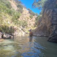
Sometime you have some pools...

Here would be a good entry t...
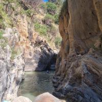
After a while it gets more e...
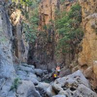
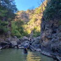
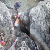
A tricky downclimb where we...


First bolt

First 10m rappel

From below

20m rap

Next approx 15m
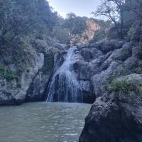
Another one where downclimb...

Big waterfall with handline...

Do NOT exit the canyon here

Next waterfall, a smaller on...

Next water fall, a big one

Walk back on water way until...
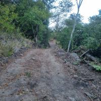
Gravel road back to car

Car park at Exit

Approach from commercial ent...

Approach from commercial ent...

Approach from commercial ent...

First rep of 110m wall
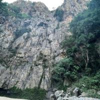
110m wall from the bottom

Last 2 reps of 110m wall