moins difficile
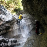
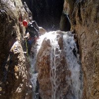
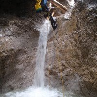
Teufelsklamm
v3 a3 III
3h15
40min
2h30
5min
1020m
840m
180m
13m
2x20m
16
1900m
à pied
Évaluation:
★★★★★
2.1 (7)
Info:
★★★
3 (1)
Belay:
★★★
2.4 (5)
Résumé:
traduction alternative
➜
Langue originale
Abseilcanyon in schrofigem Gelände
Rappel canyon in rugged terrain
Résumé:
traduction alternative
➜
Langue originale
Abseilcanyon in schrofigem Gelände
Rappel canyon in rugged terrain
Accès:
traduction alternative
➜
Langue originale
Von St. Johann/Tirol 13,5 km auf der 312 in Richtung Lofer, dann rechts ab nach Waidring und weiter südwärts in Richtung Pillersee. Etwa 4 km nach Waldring - noch vor Erreichen des Pillersees - quert die Straße nach rechts über den Fluss. Unmittelbar vor der Brücke links ein größerer Parkplatz, kostet 2€/Tag (Stand: 06/18) - hier Auto abstellen (820 m ü.NN). \nErreichbar auch von Kössen oder Bad Reichenhall über Lofer.
From St. Johann/Tyrol 13.5 km on the 312 in the direction of Lofer, then turn right to Waidring and continue south in the direction of Pillersee. About 4 km after Waldring - before reaching the Pillersee - the road crosses to the right over the river. Immediately before the bridge on the left a larger parking lot, costs 2€/day (as of 06/18) - park your car here (820 m above sea level). \nAccessible also from Kössen or Bad Reichenhall via Lofer.
Approche (40 min):
traduction alternative
➜
Langue originale
Der Wegweisung Teufelsklamm folgend den Forstweg ca. 40 Min.in südöstlicher Richtung steil hinauf, bis sich links ein kurzer und angenehmer Zustieg in das Bachbett eröffnet (1040 m ü.NN).\nGut zu kombinieren (an einem Tag) mit dem kurzen Taxabach.
Follow the sign Teufelsklamm (Devil's Gorge) up the forest road for about 40 minutes in a southeasterly direction until a short and pleasant access to the streambed opens up on the left (1040 m above sea level).\nGood to combine (on one day) with the short Taxabach.
Tour (2 h 30):
traduction alternative
➜
Langue originale
Weitgehend offen, einige Engstellen, einige Abseiler über Geschiebesperren. Der Bach wird auch kommerzell begangen, weshalb auch die Einrichtungen optimiert sind (2011).\nGut zu kombinieren (an einem Tag) mit dem kurzen Taxabach.
Largely open, some narrows, some rappel over bedload barriers. The stream is also used commercially, which is why the facilities are optimized (2011).\nGood to combine (in one day) with the short Taxabach.
Retour (5 min):
traduction alternative
➜
Langue originale
Nach den letzten beiden Geschiebesperren links hinaus.
After the last two bedload barriers, exit to the left.
Coordonnées:
Départ du Canyon
47.5549°, 12.5788°
↓↑
DMS: 47° 33" 17.64', 12° 34" 43.68'
DM: 47° 33.294", 12° 34.728"
Google Maps
Autriche Topographique
DMS: 47° 33" 17.64', 12° 34" 43.68'
DM: 47° 33.294", 12° 34.728"
Google Maps
Autriche Topographique
Fin du Canyon
47.5576°, 12.5692°
↓↑
DMS: 47° 33" 27.36', 12° 34" 9.12'
DM: 47° 33.456", 12° 34.152"
Google Maps
Autriche Topographique
DMS: 47° 33" 27.36', 12° 34" 9.12'
DM: 47° 33.456", 12° 34.152"
Google Maps
Autriche Topographique
Parking à l'entrée et à la sortie
47.5578°, 12.56721°
↓↑
DMS: 47° 33" 28.08', 12° 34" 1.96'
DM: 47° 33.468", 12° 34.033"
Google Maps
Autriche Topographique
DMS: 47° 33" 28.08', 12° 34" 1.96'
DM: 47° 33.468", 12° 34.033"
Google Maps
Autriche Topographique
Littérature:
Carte
1:25000
Carte
1:50000
Carte
1:50000
Carte
1:50000
Livre Canyoning
Alexander Riml / Gunnar Amor
2012
Info canyon Cwiki
Info canyon Descente
Info canyon Ropewiki
24.08.2024
Gabriel
⭐
★★★★★
📖
★★★
⚓
★★★
💧
Faible
Terminé ✔
traduction alternative
➜
Langue originale
Beim Zustieg nach ca 12 min nicht den Wegweiser Richtung Teufelsklamm folgen, sondern auf dem Forstweg bleiben.
Alle Sicherungen ok
After about 12 minutes of access, do not follow the signs to Teufelsklamm, but stay on the forest path.
All belays ok
04.08.2024
Joey CIA
⭐
★★★★★
📖
★★★
⚓
★★★
💧
Haut
Terminé ✔
traduction alternative
➜
Langue originale
Ordentlicher Wasserstand nach dem Regen,unteren Teil begangen ab Brücke. Ziemlich zugekiest alles.
Alle i.o
Decent water level after the rain, lower part accessible from the bridge. Pretty much covered in gravel.
All ok
16.05.2024
Joey CIA
⭐
★★★★★
📖
★★★
⚓
★★★
💧
Normale
Terminé ✔
traduction alternative
➜
Langue originale
Unterer Teil begangen, Alles Ok
Lower part committed, everything ok
15.07.2023
Montie
⭐
★★★★★
📖
★★★
⚓
★★★
💧
Faible
Terminé ✔
pas de traduction disponible
The lower part is, for my taste, way too commercialized. Steel ziplines and other stuff all over the place.
02.05.2023
Joey CIA
⭐
★★★★★
📖
★★★
⚓
★★★
💧
Haut
Terminé ✔
traduction alternative
➜
Langue originale
Nur den unteren Teil gemacht, an der Holzbrücke!
Guter Wasserdurchfluss! Keine Probleme! Installationen alle in Ordnung.
Only made the lower part, at the wooden bridge!
Good water flow! No problems! Installations all in order.
09.03.2023
System User
⭐
★★★★★
📖
★★★
⚓
★★★
pas de traduction disponible
Info: Teile der Canyonbeschreibung wurden automatisiert übernommen. Konkret die Felder Weblinks, Koordinaten, Rating, Länge des Canyon, Einfachseil Mindestens von https://www.descente-canyon.com/canyoning/canyon/22124
09.03.2023
System User
⭐
★★★★★
📖
★★★
⚓
★★★
pas de traduction disponible
Daten importiert von https://canyon.carto.net/cwiki/bin/view/Canyons/TeufelsklammCanyon.html
Nouveau rapport
Veuillez décrire brièvement et de manière concise les informations les plus importantes de la dernière visite ou les informations actuelles importantes sur le canyon. Si nécessaire avec des liens vers des vidéos, photos, etc.
*
*
*
Esc
Del
Hydrologie: