un peu difficile
Gondo
Pays:
Schweiz / Switzerland
Région: Kanton Wallis / Canton du Valais
Sous-régione: Bezirk Brig
Ville: Gondo
v4 a4 II
3h2
2min
3h
0min
1056m
850m
206m
35m
2x40m
8
620m
Voiture facultative
Spécialités:
Barrage (chasse d'eau automatique)
Barrage (chasse d'eau automatique)
Évaluation:
★★★★★
4.2 (4)
Info:
★★★
3 (2)
Belay:
★★★
3 (2)
Résumé:
traduction alternative
➜
Langue originale
Schöne aquatische Gneis- Schlucht; mehrere Sprung- und Rutschmöglichkeiten (nach Kontrolle der Wassertiefe); mehrere rutschige Passagen; automatisches Kraftwerk; Info evtl. bei Lokals einholen (www.zwischenbergenschlucht.ch); mehrere Notausstiege auf der li Seite; Felsbogen im unteren Teil; zum Teil schwieriger Seilabzug; einige Absicherungen verbogen jedoch noch ausreichend; beste Einstiegszeit ca. 11Uhr da nördliche Exposition.
Auskunft zum Staudamm bei:
Energie Electrique du Simplon SA Tel.+41 (0)27 966 54 00.
evtl. Gemeindeverwaltung Gondo: +41 (0)27 979 15 01
Beautiful aquatic gneiss canyon; several jumps and slides (after checking the water depth); several slippery passages; automatic power station Info possibly catch up with locals (www.zwischenbergenschlucht.ch); several emergency exits on the left side; rock arch in the lower part; partly difficult rope retrival; some protections bent but still sufficient; best entry time about 11am since northern exposure.
Information about the dam at:
Energie Electrique du Simplon SA Tel.+41 (0)27 966 54 00.
Possibly the municipal administration of Gondo: +41 (0)27 979 15 01.
août - septembre
11-13 Heures
Nord
Gneiss
Résumé:
traduction alternative
➜
Langue originale
Schöne aquatische Gneis- Schlucht; mehrere Sprung- und Rutschmöglichkeiten (nach Kontrolle der Wassertiefe); mehrere rutschige Passagen; automatisches Kraftwerk; Info evtl. bei Lokals einholen (www.zwischenbergenschlucht.ch); mehrere Notausstiege auf der li Seite; Felsbogen im unteren Teil; zum Teil schwieriger Seilabzug; einige Absicherungen verbogen jedoch noch ausreichend; beste Einstiegszeit ca. 11Uhr da nördliche Exposition.
Auskunft zum Staudamm bei:
Energie Electrique du Simplon SA Tel.+41 (0)27 966 54 00.
evtl. Gemeindeverwaltung Gondo: +41 (0)27 979 15 01
Beautiful aquatic gneiss canyon; several jumps and slides (after checking the water depth); several slippery passages; automatic power station Info possibly catch up with locals (www.zwischenbergenschlucht.ch); several emergency exits on the left side; rock arch in the lower part; partly difficult rope retrival; some protections bent but still sufficient; best entry time about 11am since northern exposure.
Information about the dam at:
Energie Electrique du Simplon SA Tel.+41 (0)27 966 54 00.
Possibly the municipal administration of Gondo: +41 (0)27 979 15 01.
Accès:
traduction alternative
➜
Langue originale
Von Domodossola auf der SS33 Richtung Simplonpaß (Schweiz). In Gondo, gleich nach der Schweizer Grenze (vor der Tankstelle) li zum Parkplatz hinunter. Hier kann das Überstellungsfahrzeug direkt neben dem Ausstieg geparkt werden. Mit dem 2. PKW fährt man hinter dem Parkplatz die Bergstraße (mehrere Serpentinenkurven) hoch. Nach der letzten Serpentine kommen ein paar Häuser. Hier noch vor der kleinen Gabelung li beim Spiegel parken.
approx. 20min+5min
From Domodossola on the SS33 direction Simplon Pass (Switzerland). In Gondo, just after the Swiss border (before the gas station) turn left down to the parking lot. Here you can park the shuttle car right next to the exit. With the 2nd car you drive behind the parking lot up the mountain road (several serpentine curves). After the last serpentine there are a few houses. Park here still before the small fork left at the mirror.
Approche (2 min):
traduction alternative
➜
Langue originale
(zu Fuß: 20min)
Vom Parkplatz geht man ein paar Meter vor bis man deutliche Steigspuren in den Bach (1056m)sieht. Ohne Überstellungsfahrzeug folgt man der Bergstraße bis zum Wanderweg "Stockalperweg" Der Weg kreuzt ein paar Mal die Straße. Nach ca. 20min. trifft man auf den Einstiegsparkplatz.
2min/20min
From the parking lot, go forward a few meters until you see clear climbing tracks in the stream (1056m). Without a shuttle car, follow the mountain road until you reach the hiking trail "Stockalperweg" The trail crosses the road a few times. After about 20min. you reach the parking entry. It is highly advisable to check the water level beforehand, from the lowest wooden bridge (key point).
Tour (3 h):
traduction alternative
➜
Langue originale
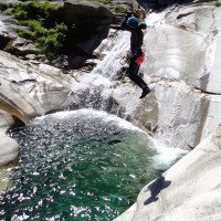
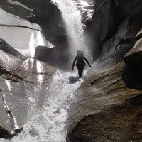
Die kontinuierlich wasserreiche Schlucht bietet Rutschen, Sprünge und Abseiler in zum Teil sehr tiefe Gumpen. Der Wasserstand bzw. Wassertiefe sollte vorher immer kontrolliert werden! Einige Becken werden bei höherem Wasserstand rückläufig. Auch die Abseilstellen, besonderes im unteren Teil (Schlüsselstelle) werden dann sehr gefährlich. Die Schlucht bleibt bis zum Schluss sehr unterhaltsam, sollte aber nie unterschätzt werden. Einer der Highlights im unteren Teil, ist ein riesiger Felsbogen unter dem man durchschwimmt (Sprungmöglichkeiten). Vor dem Schlußwasserfall kann man sich entscheiden ob man li aussteigt oder weiter absteigt (C40+ abklettern).
The continuous watery canyon offers slides, jumps and rappel in partly very deep pools. The water level or depth should always be checked beforehand! Some pools regress at higher water levels. Also the abseils, especially in the lower part (key section) then become very dangerous. The canyon remains very entertaining until the end, but should never be underestimated. One of the highlights in the lower part, is a huge rock arch under which you swim through (possible jumps). Before the final waterfall, you can decide whether to exit left or continue descending (C40+ downclimb).
Retour (0 min):
traduction alternative
➜
Langue originale
Man kann bei ca. 920m vor dem letzten Wasserfall li aus der Schlucht, über einen kleinen Pfad aussteigen. Dieser führt zur Straße und in Kürze zurück zum Parkplatz.
2. Möglichkeit: Man seilt sich über den letzten Wasserfall ca. 40m ab und klettert den Rest re über Steinplatten bis zur Einmündung der Doveria auf 850m. Dann zum Parkplatz li aussteigen.
approx. 0min/10min
You can get out of the canyon at about 920m before the last waterfall on the left, via a small path. This leads to the road and shortly back to the parking lot.
2nd option: rappel over the last waterfall for about 40m and climb the rest on the right over stone slabs to the confluence of the Doveria at 850m. Then exit to the parking lot on the left.
Coordonnées:
Départ du Canyon
46.1898°, 8.1418°
↓↑
DMS: 46° 11" 23.28', 8° 8" 30.48'
DM: 46° 11.388", 8° 8.508"
Google Maps
Suisse Topographique
DMS: 46° 11" 23.28', 8° 8" 30.48'
DM: 46° 11.388", 8° 8.508"
Google Maps
Suisse Topographique
(cwiki_1)
Fin du Canyon
46.194°, 8.1396°
↓↑
DMS: 46° 11" 38.4', 8° 8" 22.56'
DM: 46° 11.64", 8° 8.376"
Google Maps
Suisse Topographique
DMS: 46° 11" 38.4', 8° 8" 22.56'
DM: 46° 11.64", 8° 8.376"
Google Maps
Suisse Topographique
(cwiki_1)
Info canyon Cwiki
Info canyon Descente
Info canyon Ropewiki
Info canyon Schlucht.ch
21.09.2024
florentb2006
⭐
★★★★★
📖
★★★
⚓
★★★
💧
Normale
Terminé ✔
pas de traduction disponible
Automatisch importiert von Descente-Canyon.com für Canyon Gondo
Canyon parcouru avec des clients...attention le barrages a apparemment purgé des milliers de tonnes de sable et de boue, les vasques sont quasi pleines pourtant elles sont profondes....obligation de sonder de partout avant de tenter un saut ou toboggan....seule la partie finale est peu prêt propre....l'eau est par conséquent trouble, ce qui rajoute une difficulté pour sonder....je penses qu'il n'y a presque pas de poissons qui aurait pu survivre, merci pour les actions toujours très écologiques des barrages Valaisans !!priorité au fric et à la production comme d'habitude....ils font chier ces canyoneurs ils sont jamais contents !!!
(Quelle: https://www.descente-canyon.com/canyoning/canyon-debit/2750/observations.html)
01.09.2024
Franz Baumgartner
⭐
★★★★★
📖
★★★
⚓
★★★
pas de traduction disponible
Automatisch importiert von Schlucht.ch für Canyon Gondo - Zwischbergenschlucht, Wasserstand: "Tief. " Verankerungen: "Gut. "
Hübsche Verhältnisse.
(Quelle: https://schlucht.ch/schluchten-der-schweiz-liste/1031-gondo-zwischbergenschlucht)
17.08.2024
apalomer
⭐
★★★★★
📖
★★★
⚓
★★★
💧
Normale
Terminé ✔
pas de traduction disponible
Automatisch importiert von Descente-Canyon.com für Canyon Gondo
(Quelle: https://www.descente-canyon.com/canyoning/canyon-debit/2750/observations.html)
10.08.2024
Lobster_quentin
⭐
★★★★★
📖
★★★
⚓
★★★
💧
Normale
Terminé ✔
pas de traduction disponible
Automatisch importiert von Descente-Canyon.com für Canyon Gondo
(Quelle: https://www.descente-canyon.com/canyoning/canyon-debit/2750/observations.html)
09.08.2024
maxime_b
⭐
★★★★★
📖
★★★
⚓
★★★
💧
Normale
Terminé ✔
pas de traduction disponible
Automatisch importiert von Descente-Canyon.com für Canyon Gondo
(Quelle: https://www.descente-canyon.com/canyoning/canyon-debit/2750/observations.html)
02.08.2024
florentb2006
⭐
★★★★★
📖
★★★
⚓
★★★
💧
Normale
Terminé ✔
pas de traduction disponible
Automatisch importiert von Descente-Canyon.com für Canyon Gondo
parcouru intégralement avec le perfo et des clients. Avons reequipé quelques relais qui étaient bien pliés.débit qui augmente avec l'affluence rive droite. un énorme névé qui double quasiment le débit.un peu de graviers dans certaines vasques mais tout passe bien sauts toboggans. Rappels avec des nouveaux relais. j'espère qu'ils supporteront quelques crues.....
(Quelle: https://www.descente-canyon.com/canyoning/canyon-debit/2750/observations.html)
01.08.2024
Yan09
⭐
★★★★★
📖
★★★
⚓
★★★
💧
Normale
Terminé ✔
pas de traduction disponible
Automatisch importiert von Descente-Canyon.com für Canyon Gondo
Dc++, ça pousse dans les cascades. L'arche est juste exceptionnel... le rappel dans la faille est superbe. Tob eject au départ, sauts, eau transparente, que du bonheur. Beaucoup de relais défoncés par les crues ont été rénové mais pas tous...
(Quelle: https://www.descente-canyon.com/canyoning/canyon-debit/2750/observations.html)
11.06.2024
charly67
⭐
★★★★★
📖
★★★
⚓
★★★
🌊
Fou
Terminé ✕
pas de traduction disponible
Automatisch importiert von Descente-Canyon.com für Canyon Gondo
(Quelle: https://www.descente-canyon.com/canyoning/canyon-debit/2750/observations.html)
08.09.2023
Wolfgang
⭐
★★★★★
📖
★★★
⚓
★★★
💧
Normale
Terminé ✔
traduction alternative
➜
Langue originale
Alles gut hier , schnelle nette Tour
All good here , fast nice tour
31.08.2023
Patrick Summerer
⭐
★★★★★
📖
★★★
⚓
★★★
💧
Normale
Terminé ✔
traduction alternative
➜
Langue originale
Alle Stände nach Hochwasser noch vorhanden, einige Rutschen möglich, Sprung vom wunderschönen Steinbogen möglich. Kaltes Wasser!
All stands after high water still available, some slides possible, jump from the beautiful stone arch possible. Cold water!
09.03.2023
System User
⭐
★★★★★
📖
★★★
⚓
★★★
pas de traduction disponible
Info: Teile der Canyonbeschreibung wurden automatisiert übernommen. Konkret die Felder Weblinks, Koordinaten, Rating, Ort, Länge des Canyon, Einfachseil Mindestens von https://canyon.carto.net/cwiki/bin/view/Canyons/GondoCanyon.html und https://www.descente-canyon.com/canyoning/canyon/2750
09.03.2023
System User
⭐
★★★★★
📖
★★★
⚓
★★★
pas de traduction disponible
Daten importiert von https://www.canyoning.or.at/index.php/liste-aller-canyons/370-gondo
15.08.2022
Bubtore
⭐
★★★★★
📖
★★★
⚓
★★★
💧
Faible
Terminé ✔
traduction alternative
➜
Langue originale
Sehr wenig Wasser, Sprünge waren alle machbar.
Very little water, jumps were all doable.
Nouveau rapport
Veuillez décrire brièvement et de manière concise les informations les plus importantes de la dernière visite ou les informations actuelles importantes sur le canyon. Si nécessaire avec des liens vers des vidéos, photos, etc.
*
*
*
Esc
Del
Hydrologie:
pas de traduction disponible
Auskunft zum Staudamm bei:
Energie Electrique du Simplon SA Tel.+41 (0)27 966 54 00
evtl. Gemeindeverwaltung Gondo: +41 (0)27 979 15 01
Es ist sehr ratsam den Wasserstand vorher, von der untersten Holzbrücke (Schlüsselstelle), zu kontrollieren.