v4 a1 II
4h
1h10
2h30
20min
950m
620m
330m
40m
2x50
12
1m
à pied
Engrenages:
outil de forage
outil de forage
Évaluation:
★★★★★
0 ()
Info:
★★★
0 ()
Belay:
★★★
0 ()
Résumé:
traduction alternative
➜
Langue originale
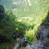
Besonders nach Regenfällen attraktiver Waldgraben. Highlight sind zwei aufeinanderfolgende Abseiler, welche freihängend und vor einer "Grotte/Höhle" sind.
Die Tour wurde nur notdürftig eingerichtet! Man sollte daher am besten eine Bohrmaschine mitnehmen und evtl. sind einige Abseiler über Bäume zu absolvieren.
An attractive forest canyon, especially after rainfall. The highlight are two consecutive rappels, which are free-hanging and in front of a "grotto/cave".
The tour has only been set up in a makeshift manner! It is therefore best to take a drill with you and you may have to do some rappels over trees.
avril - octobre
8-16 Heures
Est
Calcaire
2.00km²
Résumé:
traduction alternative
➜
Langue originale
Besonders nach Regenfällen attraktiver Waldgraben. Highlight sind zwei aufeinanderfolgende Abseiler, welche freihängend und vor einer "Grotte/Höhle" sind.
Die Tour wurde nur notdürftig eingerichtet! Man sollte daher am besten eine Bohrmaschine mitnehmen und evtl. sind einige Abseiler über Bäume zu absolvieren.
An attractive forest canyon, especially after rainfall. The highlight are two consecutive rappels, which are free-hanging and in front of a "grotto/cave".
The tour has only been set up in a makeshift manner! It is therefore best to take a drill with you and you may have to do some rappels over trees.
Accès:
traduction alternative
➜
Langue originale
Wir fahren von Kössen in Richtung St. Johann in Tirol auf der Erpfendorfer Landstraße (L39), bis die Straße die Tiroler Ache/Großache überquert. Direkt bei der Brücke auf dem Parkplatz können wir unser Auto abstellen.
We drive from Kössen in the direction of St. Johann in Tirol on the Erpfendorfer Landstraße (L39) until the road crosses the Tiroler Ache/Großache. We can park our car in the parking lot right by the bridge.
Approche (1 h 10):
traduction alternative
➜
Langue originale
Wir gehen auf der Forststraße entlang in Richtung Kössen, bis nach ca. 1,3km auf der linken Seite einem Wanderweg in Richtung des Berges führt. Diesem folgen wir entlang des Kalkgrabens, der auf der rechten Seite des Weges vorbeiläuft. Wenn der Weg an einem Bach endet (Notausstieg unserer Tour), überqueren wir diesen und folgen dem serpentinenartigen Trampelpfad bis wir erneut auf den Bach treffen. Wenn wir an der Holzleiter, welche am Bach steht, angelangt sind, dann sind wir richtig und können einsteigen. Die Tour wurde nur notdürftig eingerichtet! Man sollte daher am besten eine Bohrmaschine mitnehmen und evtl. sind einige Abseiler über Bäume zu absolvieren.
We walk along the forest road in the direction of Kössen until after approx. 1.3km a hiking trail on the left leads towards the mountain. We follow this along the Kalkgraben, which runs past on the right-hand side of the path. When the path exits at a stream (emergency exit of our tour), we cross it and follow the serpentine trail until we reach the stream again. When we reach the wooden ladder by the stream, we are in the right place and can climb in. The tour is only makeshift! It is therefore best to take a drill with you and you may have to do some rappels over trees.
Tour (2 h 30):
traduction alternative
➜
Langue originale
Es handelt sich hierbei um eine eher trockene, nicht sehr tief eingeschnittene Tour, welche nur zu gewissen Zeiten nach starken Regen Wasser führt. Highlight der Tour sind zwei aufeinander folgende Abseiler mit jeweils einer größeren Grotte/Höhle, bei der freihängend abgeseilt wird.
This is a rather dry, not very deep tour, which only carries water at certain times after heavy rain. The highlight of the tour are two consecutive rappels, each with a larger grotto/cave, where free-hanging rappels are used.
Retour (20 min):
traduction alternative
➜
Langue originale
Die Tour endet direkt an der Forststraße neben der Tiroler Ache/Großache. Wir folgen dieser rechts für ca. 1,3km bis wir am Parkplatz angekommen sind
The tour exits directly at the forest road next to the Tiroler Ache/Großache. We follow this road to the right for approx. 1.3 km until we reach the parking lot
Coordonnées:
Départ du Canyon
47.62994°, 12.450665°
↓↑
DMS: 47° 37" 47.79', 12° 27" 2.39'
DM: 47° 37.796", 12° 27.04"
Google Maps
Autriche Topographique
DMS: 47° 37" 47.79', 12° 27" 2.39'
DM: 47° 37.796", 12° 27.04"
Google Maps
Autriche Topographique
Fin du Canyon
47.63236°, 12.457163°
↓↑
DMS: 47° 37" 56.49', 12° 27" 25.79'
DM: 47° 37.942", 12° 27.43"
Google Maps
Autriche Topographique
DMS: 47° 37" 56.49', 12° 27" 25.79'
DM: 47° 37.942", 12° 27.43"
Google Maps
Autriche Topographique
Fin alternative du canyon
47.632352°, 12.45504°
↓↑
DMS: 47° 37" 56.47', 12° 27" 18.15'
DM: 47° 37.941", 12° 27.302"
Google Maps
Autriche Topographique
DMS: 47° 37" 56.47', 12° 27" 18.15'
DM: 47° 37.941", 12° 27.302"
Google Maps
Autriche Topographique
Site de mesure du niveau d'eau
47.632366°, 12.455052°
↓↑
DMS: 47° 37" 56.52', 12° 27" 18.19'
DM: 47° 37.942", 12° 27.303"
Google Maps
Autriche Topographique
DMS: 47° 37" 56.52', 12° 27" 18.19'
DM: 47° 37.942", 12° 27.303"
Google Maps
Autriche Topographique
Site de mesure du niveau d'eau
47.634593°, 12.460952°
↓↑
DMS: 47° 38" 4.54', 12° 27" 39.43'
DM: 47° 38.076", 12° 27.657"
Google Maps
Autriche Topographique
DMS: 47° 38" 4.54', 12° 27" 39.43'
DM: 47° 38.076", 12° 27.657"
Google Maps
Autriche Topographique
Parking à l'entrée et à la sortie
47.621262°, 12.464583°
↓↑
DMS: 47° 37" 16.54', 12° 27" 52.5'
DM: 47° 37.276", 12° 27.875"
Google Maps
Autriche Topographique
DMS: 47° 37" 16.54', 12° 27" 52.5'
DM: 47° 37.276", 12° 27.875"
Google Maps
Autriche Topographique
Hydrologie:
traduction alternative
➜
Langue originale
Dieser Bach führt in der Regel wenig Wasser. Besonders Lohnenswert nach Regenfällen, wenn viele andere Touren zu viel Wasser führen.
This stream usually carries little water. Particularly worthwhile after rainfall, when many other tours carry too much water.
Site de mesure du niveau d'eau
Site de mesure du niveau d'eau


