difficile
Auerklamm (ab Wolfsbrücke)
v4 a5 IV
3h40
10min
3h
30min
1020m
780m
240m
40m
2x 45m/1x20m
20
Voiture facultative
Évaluation:
★★★★★
3.5 (6)
Info:
★★★
2.8 (4)
Belay:
★★★
3 (4)
Résumé:
traduction alternative
➜
Langue originale
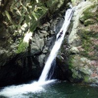
Sehr wasserreiche Schlucht mit einigen tiefen Gumpen, 40m hoher aquatischer Wasserfall umgehbar; sehr rutschig; anspruchsvolle Tour; viele Abseilstellen, Rutschen und Sprünge; großes Einzugsgebiet; Granitgestein; sehr gut abgesichert; Stausee und Staubecken oberhalb der Schlucht in Sellrain -Silz
!Hinweistafel von evtl. Spülungen beachten; bei hohen Wasserstand sehr gefährlich!;
Vor Begehung unbedingt Pegel bei Meßstab orografisch links unterhalb des letzten Beckens prüfen (roter Bereich - nicht einsteigen, blauer Bereich oder weniger - OK)
viele Stellen können meist rutschend oder springend bewältigt werden; der obere Teil der Auerklamm (oberhalb der Wolfsbrücke) wird nicht empfohlen, da man Privatbesitz durchquert; wird sehr stark kommerziell begangen.
Es erscheint an dieser Stelle angezeigt, die verschiedenen Abschnitte des Nederbachs, soweit sie üblicherweise canyoningmäßig begangen werden, zu gliedern, um dann die entsprechenden Bezeichnungen zuzuordnen.
Der 1. Abschnitt in der Nähe des Weilers Mareil ist rund 8 km von Taxegg und damit den Abschnitten der Auerklamm entfernt. Unter den vielen Bezeichnungen sind die relativ häufig genannten Alpenrosenklamm bzw. Stopfer. Ich habe diesen Abschnitt auch als Nederbach I bezeichnet (Näheres zu diesem Aschnitt unter "Alpenrosenklamm").
Der 2.Abschnitt hängt mit den weiteren Abschnitten 3 (und ggf. 4) ohne eindeutige räumliche Unterbrechung zusammen. Dieser Abschnitt beginnt in Mühlau und endet bei der Wolfsbrücke. Wenn man von Auerklamm sprach, hatte man früher in aller Regel nur den Nederbach-Abstieg ab Wolfsbrücke im Auge. Grund dafür dürfte sein , dass schon die frühe vor allem kommerzielle Canyoningausübung im Nederbach sich im wesentlichen auf diesen unteren Bereich beschränkte. Relativ spät erst wurde dieser 2. Abschnitt eingesichert und auch heute noch ist er im Wesentlichen kommerziellen Veranstaltern vorbehalten. Siehe dazu auch die obige Empfehlung, diesen Abschnitt besser nicht zu begehen. Zudem kommt die Qualität dieses Abschnitts nicht an die Attraktivität des Bereichs unterhalb der Wolfsbrücke heran (zu diesem Abschnitt näher unter "Obere Auerklamm" bzw. Nederbach II).
Der 3. Abschnitt beginnt nun an der Wolfsbrücke. Nach einer Auffassung zieht sich dieser 3. Abschnitt bis hinunter zum endgültigen Ende der Schlucht an der Holzbrücke auf Höhe 760m üNN. Diese Auffassung besteht vor allem, wenn auch nicht ausschließlich bei den Canyoning Ausübenden ohne kommerziellen Bezug. Letztlich liegt sie auch dieser Beschreibung zugrunde.
Die Guides im kommerziellen Tätigkeitsfeld haben diesen Bereich aber schon seit jeher noch einmal in 2 Teile, somit einen 3. und einen 4. Abschnitt gegliedert (so auch Riml/Amor oder die ASI Tirol - siehe Links). Grund dafür waren neben der Optimierung des Geschäftsmodells (ua. Zeitaufwand und Verdienst ) auch der Umstand, dass diese 2 Teile auch unterschiedliche Schwierigkeiten und Risiken beinhalteten. Ein Aspekt war insoweit, der im ersten Teil zu findende 45m-Fall, der im meist im doch recht kräftigen Strahl zu seilen war. Inzwischen ist hier jedoch auch eine "Trockenroute" eingebohrt.
Ob man nun diese weitere Untergliederung in Nederbach III und IV, entsprechend Mittl. u. Untere Auerklamm für angemessen erachtet, ist nach meinem Dafürhalten Geschmackssache. Da jedoch hier eine einheitliche Beschreibung für diesen gesamten Bereich ab Wolfsbrücke bereits vorliegt, nehme ich das als Ausgangspunkt auch für meine Glederung, dh., Nederbach III bzw Auerklamm ab Wolfsbrücke bis Schluchtende muß nicht in 2 Beschreibungen zerlegt werden. Die mehreren Zu- und Ausstiegsmöglichkeiten - inzwischen beidseitig - nehmen diesem dritten Abschnitt nicht den Charakter der Einheit.
Oder ökonomisch gedacht: Wer hier 2 Beschreibungen für einen zweigeteilten Bereich unterhalb der Holzbrücke haben will, wird wohl nicht daran gehindert, diese neu zu entwerfen.
Very watery canyon with some deep pools, 40m high aquatic waterfall can be bypassed; very slippery; challenging tour; many abseiling points, slides and jumps; large catchment area; granite rock; very well secured; reservoir and reservoir above the canyon in Sellrain -Silz
!Pay attention to the information board about possible flushing; very dangerous at high water levels!
Before entering, be sure to check the level at the orographic measuring stick on the left below the last basin (red area - do not enter, blue area or less - OK).
Many sections can usually be negotiated by sliding or jumping; the upper part of the Auerklamm (above the Wolfsbrücke) is not recommended as it crosses private property; very commercialized.
At this point, it seems appropriate to divide the different parts of the Nederbach, as far as they are usually canyoned, and then assign the corresponding designations.
The 1st part near the hamlet of Mareil is around 8 km from Taxegg and thus the parts of the Auerklamm. Among the many names are the relatively frequently mentioned Alpenrosenklamm and Stopfer. I have also referred to this part as Nederbach I (for more details on this parts see "Alpenrosenklamm").
The 2nd section is connected to the other parts 3 (and possibly 4) without a clear spatial interruption. This part begins in Mühlau and exits at Wolfsbrücke. In the past, when people spoke of Auerklamm, they generally only had the Nederbach descent from Wolfsbrücke in mind. This is probably due to the fact that early commercial canyoning in the Nederbach was essentially limited to this lower section. This 2nd part was only made safe relatively late and even today it is mainly reserved for commercial organizers. See also the recommendation above to avoid this part. In addition, the quality of this part does not come close to the attractiveness of the area below the Wolfsbrücke bridge (for more information on this part, see "Obere Auerklamm" or Nederbach II).
The 3rd part now begins at the Wolfsbrücke bridge. According to one view, this 3rd part extends down to the final exit of the canyon at the wooden bridge at 760m above sea level. This view exists mainly, although not exclusively, among canyoning practitioners with no commercial connection. Ultimately, it is also the basis of this description.
However, guides in the commercial field of activity have always divided this area into 2 parts, i.e. a 3rd and a 4th part (also Riml/Amor or ASI Tirol - see links). The reason for this was not only the optimization of the business model (including time expenditure and earnings) but also the fact that these 2 parts also involved different difficulties and risks. One aspect in this respect was the 45m fall in the first part, which usually had to be roped in a rather powerful beam. In the meantime, however, a "dry route" has also been drilled here.
Whether one considers this further subdivision into Nederbach III and IV, corresponding to Mittl. and Untere Auerklamm, to be appropriate is, in my opinion, a matter of taste. However, since there is already a uniform description for this entire area from Wolfsbrücke, I take this as the starting point for my description, i.e. Nederbach III or Auerklamm from Wolfsbrücke to the canyon exit does not have to be divided into 2 descriptions. The several access and exit possibilities - now on both sides - do not take away the character of unity from this third part.
Or to put it economically: if you want to have 2 descriptions for a two-part section below the wooden bridge, there is nothing to stop you from redesigning it.
Ouest
Granit
22.00km²
Résumé:
traduction alternative
➜
Langue originale
Sehr wasserreiche Schlucht mit einigen tiefen Gumpen, 40m hoher aquatischer Wasserfall umgehbar; sehr rutschig; anspruchsvolle Tour; viele Abseilstellen, Rutschen und Sprünge; großes Einzugsgebiet; Granitgestein; sehr gut abgesichert; Stausee und Staubecken oberhalb der Schlucht in Sellrain -Silz
!Hinweistafel von evtl. Spülungen beachten; bei hohen Wasserstand sehr gefährlich!;
Vor Begehung unbedingt Pegel bei Meßstab orografisch links unterhalb des letzten Beckens prüfen (roter Bereich - nicht einsteigen, blauer Bereich oder weniger - OK)
viele Stellen können meist rutschend oder springend bewältigt werden; der obere Teil der Auerklamm (oberhalb der Wolfsbrücke) wird nicht empfohlen, da man Privatbesitz durchquert; wird sehr stark kommerziell begangen.
Es erscheint an dieser Stelle angezeigt, die verschiedenen Abschnitte des Nederbachs, soweit sie üblicherweise canyoningmäßig begangen werden, zu gliedern, um dann die entsprechenden Bezeichnungen zuzuordnen.
Der 1. Abschnitt in der Nähe des Weilers Mareil ist rund 8 km von Taxegg und damit den Abschnitten der Auerklamm entfernt. Unter den vielen Bezeichnungen sind die relativ häufig genannten Alpenrosenklamm bzw. Stopfer. Ich habe diesen Abschnitt auch als Nederbach I bezeichnet (Näheres zu diesem Aschnitt unter "Alpenrosenklamm").
Der 2.Abschnitt hängt mit den weiteren Abschnitten 3 (und ggf. 4) ohne eindeutige räumliche Unterbrechung zusammen. Dieser Abschnitt beginnt in Mühlau und endet bei der Wolfsbrücke. Wenn man von Auerklamm sprach, hatte man früher in aller Regel nur den Nederbach-Abstieg ab Wolfsbrücke im Auge. Grund dafür dürfte sein , dass schon die frühe vor allem kommerzielle Canyoningausübung im Nederbach sich im wesentlichen auf diesen unteren Bereich beschränkte. Relativ spät erst wurde dieser 2. Abschnitt eingesichert und auch heute noch ist er im Wesentlichen kommerziellen Veranstaltern vorbehalten. Siehe dazu auch die obige Empfehlung, diesen Abschnitt besser nicht zu begehen. Zudem kommt die Qualität dieses Abschnitts nicht an die Attraktivität des Bereichs unterhalb der Wolfsbrücke heran (zu diesem Abschnitt näher unter "Obere Auerklamm" bzw. Nederbach II).
Der 3. Abschnitt beginnt nun an der Wolfsbrücke. Nach einer Auffassung zieht sich dieser 3. Abschnitt bis hinunter zum endgültigen Ende der Schlucht an der Holzbrücke auf Höhe 760m üNN. Diese Auffassung besteht vor allem, wenn auch nicht ausschließlich bei den Canyoning Ausübenden ohne kommerziellen Bezug. Letztlich liegt sie auch dieser Beschreibung zugrunde.
Die Guides im kommerziellen Tätigkeitsfeld haben diesen Bereich aber schon seit jeher noch einmal in 2 Teile, somit einen 3. und einen 4. Abschnitt gegliedert (so auch Riml/Amor oder die ASI Tirol - siehe Links). Grund dafür waren neben der Optimierung des Geschäftsmodells (ua. Zeitaufwand und Verdienst ) auch der Umstand, dass diese 2 Teile auch unterschiedliche Schwierigkeiten und Risiken beinhalteten. Ein Aspekt war insoweit, der im ersten Teil zu findende 45m-Fall, der im meist im doch recht kräftigen Strahl zu seilen war. Inzwischen ist hier jedoch auch eine "Trockenroute" eingebohrt.
Ob man nun diese weitere Untergliederung in Nederbach III und IV, entsprechend Mittl. u. Untere Auerklamm für angemessen erachtet, ist nach meinem Dafürhalten Geschmackssache. Da jedoch hier eine einheitliche Beschreibung für diesen gesamten Bereich ab Wolfsbrücke bereits vorliegt, nehme ich das als Ausgangspunkt auch für meine Glederung, dh., Nederbach III bzw Auerklamm ab Wolfsbrücke bis Schluchtende muß nicht in 2 Beschreibungen zerlegt werden. Die mehreren Zu- und Ausstiegsmöglichkeiten - inzwischen beidseitig - nehmen diesem dritten Abschnitt nicht den Charakter der Einheit.
Oder ökonomisch gedacht: Wer hier 2 Beschreibungen für einen zweigeteilten Bereich unterhalb der Holzbrücke haben will, wird wohl nicht daran gehindert, diese neu zu entwerfen.
Very watery canyon with some deep pools, 40m high aquatic waterfall can be bypassed; very slippery; challenging tour; many abseiling points, slides and jumps; large catchment area; granite rock; very well secured; reservoir and reservoir above the canyon in Sellrain -Silz
!Pay attention to the information board about possible flushing; very dangerous at high water levels!
Before entering, be sure to check the level at the orographic measuring stick on the left below the last basin (red area - do not enter, blue area or less - OK).
Many sections can usually be negotiated by sliding or jumping; the upper part of the Auerklamm (above the Wolfsbrücke) is not recommended as it crosses private property; very commercialized.
At this point, it seems appropriate to divide the different parts of the Nederbach, as far as they are usually canyoned, and then assign the corresponding designations.
The 1st part near the hamlet of Mareil is around 8 km from Taxegg and thus the parts of the Auerklamm. Among the many names are the relatively frequently mentioned Alpenrosenklamm and Stopfer. I have also referred to this part as Nederbach I (for more details on this parts see "Alpenrosenklamm").
The 2nd section is connected to the other parts 3 (and possibly 4) without a clear spatial interruption. This part begins in Mühlau and exits at Wolfsbrücke. In the past, when people spoke of Auerklamm, they generally only had the Nederbach descent from Wolfsbrücke in mind. This is probably due to the fact that early commercial canyoning in the Nederbach was essentially limited to this lower section. This 2nd part was only made safe relatively late and even today it is mainly reserved for commercial organizers. See also the recommendation above to avoid this part. In addition, the quality of this part does not come close to the attractiveness of the area below the Wolfsbrücke bridge (for more information on this part, see "Obere Auerklamm" or Nederbach II).
The 3rd part now begins at the Wolfsbrücke bridge. According to one view, this 3rd part extends down to the final exit of the canyon at the wooden bridge at 760m above sea level. This view exists mainly, although not exclusively, among canyoning practitioners with no commercial connection. Ultimately, it is also the basis of this description.
However, guides in the commercial field of activity have always divided this area into 2 parts, i.e. a 3rd and a 4th part (also Riml/Amor or ASI Tirol - see links). The reason for this was not only the optimization of the business model (including time expenditure and earnings) but also the fact that these 2 parts also involved different difficulties and risks. One aspect in this respect was the 45m fall in the first part, which usually had to be roped in a rather powerful beam. In the meantime, however, a "dry route" has also been drilled here.
Whether one considers this further subdivision into Nederbach III and IV, corresponding to Mittl. and Untere Auerklamm, to be appropriate is, in my opinion, a matter of taste. However, since there is already a uniform description for this entire area from Wolfsbrücke, I take this as the starting point for my description, i.e. Nederbach III or Auerklamm from Wolfsbrücke to the canyon exit does not have to be divided into 2 descriptions. The several access and exit possibilities - now on both sides - do not take away the character of unity from this third part.
Or to put it economically: if you want to have 2 descriptions for a two-part section below the wooden bridge, there is nothing to stop you from redesigning it.
Accès:
traduction alternative
➜
Langue originale
Von der Inntalautobahn fährt man ins Ötztal --> kurz nach dem Gasthof Ambach führt li. eine Straße Richtung Ebene --> Hier kann bei der Holzbrücke (Ausstieg) ein Schattelauto geparkt werden und der Wasserstand (! Wasserableitung) gecheckt werden --> danach fährt man wieder auf die Hauptstraße bis zur Ortschaft Ötz--> von Ötz fährt man dann auf der Bergstraße (Küthaistraße) nach Ötzerau und noch etwas weiter bis kurz vor Wies --> hier noch vor der scharfen re. Kurve in der Ausbuchtung parken (Platz für ca. 5 PKW). Der Parkplatz wird sehr stark von den Outdoorclubs genützt. Alternativ kann etwas weiter oben nach den Häusern von Wies bei der Brücke li. geparkt werden.
From the Inntal freeway, drive into the Ötztal valley --> shortly after the Ambach inn, a road leads to the left towards the plain --> here, at the wooden bridge (exit), a shadow car can be parked and the water level (! Water drainage) be checked --> then you drive back on the main road to the village of Ötz--> from Ötz you then drive on the mountain road (Küthaistraße) to Ötzerau and a little further until shortly before Wies --> here still park before the sharp right bend in the bulge (space for about 5 cars). The parking lot is very heavily used by the outdoor clubs. Alternatively, you can park a little further up after the houses of Wies at the bridge on the left.
Approche (10 min):
traduction alternative
➜
Langue originale
Bei dem markanten orangen Vermessungspunkt und einer Parkbank führt ein Weg bergab zu einer Holzbrücke. Hier ist der Einstieg in die mittlere Auerklamm (Abseilen) der nicht auf dem Topo eingezeichnet ist. Den Einstieg in die untere Auerklamm erreicht man über einen Pfad der links von der kleinen Kapelle, gleich bei der Holzbrücke, abzweigt. Steil bergab geht es ca. 10 Minuten bis man den Einstieg erreicht. Will man die Schlucht vollkommen durchsteigen so gibt es noch einen Einstieg oberhalb von Taxegg siehe obere Auerklamm/Nederbach II). Am Ortsende kommt man zu einer Brücke, und folgt dann dem Bachlauf auf der rechten Seite bis zu einem kleinen Staudamm.
Alternativ bei großem Schotterparkplatz rechts der Ötztaler Straße parken und in ca. 35min zu Fuß über steilem Wanderweg zur Brücke gehen.
At the distinctive orange survey point and a park bench, a path leads downhill to a wooden bridge. Here is the entry to the middle Auerklamm gorge (rappel) which is not marked on the topographic view. The entry to the lower Auerklamm can be reached via a path that branches off to the left of the small chapel, right by the wooden bridge. The path descends steeply for about 10 minutes until you reach the entry point. If you want to climb all the way through the canyon, there is another entry point above Taxegg (see upper Auerklamm/Nederbach II). At the end of the village you come to a bridge and then follow the course of the stream on the right-hand side until you reach a small dam.
Alternatively, park at a large gravel parking place to the right of Ötztaler Straße and walk for about 35 minutes along a steep hiking trail to the bridge.
Tour (3 h):
traduction alternative
➜
Langue originale
Abseiler über trockene ca.30m hohe Abseilstelle (scharfe Kante!) oder Brücke --> es folgt eine 10m Abseilstelle in Gumpen --> Über ein Fixseil im Wasser geht es weiter bis zur 15m Rutsche unterhalb der Wolfsbrücke --> vom engen Wasserbecken mit kurzen Fixseilen 5m in eine verwinkelte Stelle abseilen + 4m Rutsche in Gumpen --> Nach dem Gumpen gibt es li. einen Notausstieg (Möglichkeit den 40m-Wasserfall zu umgehen) --> Für die Umgehung geht man über die Wolfsbrücke und folgt den Wanderweg or. re. Talwärts vorbei an einem Aussichtspunkt --> gleich danach kann li. über einen Klettersteig wieder in den Bach abgestiegen werden --> Wird der Notausstieg nicht benötigt, geht es mit einer 3-er Rutschkombination (7m, 3m und 8m) weiter --> Danach kommt die höchste ca. 40m Abseilstelle in der Wasserführung! (Seilbahnsystem möglich, Bohrhaken am großen Fels unten li.) --> nach der hohen Stufe über Felsplatten abklettern und weiter über die 6m Felsrutsche (abseilen möglich) --> Abseilstelle (6m) --> kleine Stufe mit Fixseil --> weitere Abseilstelle außerhalb der Wasserführung ca. 10m --> Nach dem Grillplatz kommt eine ca.7-8m Rutsche die zum Teil überhängend ist (abseilen möglich) --> bei der nächsten Abseilstelle kann 5m abgeseilt werden um dann 3-4m zu springen. --> danach kommt man zum Kettenstand --> abseilen über Fixseil in Felsgrotte --> Es folgt ein Sprung 6m in den Whirlpool und eine 10m schräge Felsstufe wo man über das Fixseil in den “Dom” abseilt --> danach überquert man mit Hilfe eines Stahlseil eine Engstelle -->Es folgt ein 10m-Sprung in tiefen Gumpen und ein 5m Sprung --> zwei kleinere Abseilstellen führen zum letzten schrägen ca.30m Wasserfall --> nach dem Wasserfall endet die Tour vor der schönen Holzbrücke.
Rappel over dry approx.30m high rappel (sharp edge!) or bridge --> there follows a 10m rappel in pools --> over a fixed rope in the water it continues to the 15m slide below the Wolfsbrücke --> from the narrow pool with short fixed ropes rappel 5m into a winding place + 4m slide in pools --> After the pool there is li. an emergency exit (possibility to bypass the 40m waterfall) --> For bypassing go over the Wolfsbrücke and follow the hiking trail or. r. downhill past a lookout point --> right after that you can descend left. via via ferrata back into the stream --> If the emergency exit is not needed, continue with a 3-person slide combination (7m, 3m and 8m) --> After that comes the highest approx. 40m rappel point in the waterway! (Ropeway system possible, drill hooks on the large rock below left) --> after the high step over rock slabs downclimb and continue over the 6m rock slide (rappel possible) --> downclimb (6m) --> small step with fixed ropes --> another downclimb outside the waterway about 10m --> after the barbecue area comes a 7-8m slide which is partly overhanging (rappel possible) --> at the next downclimb you can rappel 5m and then jump 3-4m. --> after that you come to the chain anchor --> rappel over fixed ropes into a rock grotto --> a 6m jump into the whirlpool follows and a 10m sloping rock step where you rappel over the fixed rope into the "dome" --> after that you cross a narrow passage with the help of a steel rope --> a 10m jump into deep pools follows and a 5m jump --> two smaller rappel points lead to the last sloping ca.30m waterfall --> after the waterfall the tour ends in front of the beautiful wooden bridge.
Retour (30 min):
traduction alternative
➜
Langue originale
Ausstieg re. vor der Holzbrücke --> Nach der Tour mit einem Schuttelauto (Taxi) zum Einstiegsparkplatz hochfahren oder Alternativ: zu Fuß von der Holzbrücke zuerst re. der Straße bis zum gekennzeichneten Wanderweg und dann den steilen Wanderweg bis zur Wolfsbrücke und Einstiegparkplatz hoch folgen (ca. 30 min)
Exit on the right in front of the wooden bridge --> After the tour take a shuttle car (cab) up to the parking entry or alternatively: walk from the wooden bridge first on the right side of the road to the marked hiking trail and then follow the steep hiking trail up to the Wolf Bridge and parking entry (approx. 30 min)
Coordonnées:
Départ du Canyon
47.2174°, 10.8771°
↓↑
DMS: 47° 13" 2.64', 10° 52" 37.56'
DM: 47° 13.044", 10° 52.626"
Google Maps
Autriche Topographique
DMS: 47° 13" 2.64', 10° 52" 37.56'
DM: 47° 13.044", 10° 52.626"
Google Maps
Autriche Topographique
Parking à l'entrée et à la sortie
47.2168°, 10.8787°
↓↑
DMS: 47° 13" 0.48', 10° 52" 43.32'
DM: 47° 13.008", 10° 52.722"
Google Maps
Autriche Topographique
DMS: 47° 13" 0.48', 10° 52" 43.32'
DM: 47° 13.008", 10° 52.722"
Google Maps
Autriche Topographique
Fin du Canyon
47.2138°, 10.8704°
↓↑
DMS: 47° 12" 49.68', 10° 52" 13.44'
DM: 47° 12.828", 10° 52.224"
Google Maps
Autriche Topographique
DMS: 47° 12" 49.68', 10° 52" 13.44'
DM: 47° 12.828", 10° 52.224"
Google Maps
Autriche Topographique
Littérature:
Carte
Carte
1:50000
Carte
1:50000
Livre Canyoning
Stéphane Coté / Caracal et les Sancho Panza
2007
124 Canyon-Beschreibungen
Livre Canyoning
Alexander Riml / Gunnar Amor
2012
Livre Canyoning
Werner Baumgarten
2010
Livre Canyoning
Werner Baumgarten
2013
Livre Canyoning
Stéphane Coté / Caracal et les Sancho Panza
2008
Livret de canyoning
AIC
2024
Booklet des Canyoning Treffens in Südtirol 2024 - Beschreibungen übernommen nach freundlicher Genehmigung
Info canyon ACA
Info canyon Cwiki
Info canyon Descente
Info canyon Ropewiki
Autre info canyon
15.08.2024
Clarissa Linder
⭐
★★★★★
📖
★★★
⚓
★★★
💧
Normale
Terminé ✔
traduction alternative
➜
Langue originale
D'autres utilisateurs ont été: Maik Plank
Viele Rutschen/Sprünge möglich. Stände top. Viel Geschiebe in den Gehpassagen.
Many slides/jumps possible. Top stands. Lots of pushing in the walking passages.
D'autres utilisateurs ont été: Maik Plank
07.07.2024
Bavarian Canyoning
⭐
★★★★★
📖
★★★
⚓
★★★
💧
Haut
Terminé ✔
traduction alternative
➜
Langue originale
Wir sind über den Klettersteig direkt bei dem hohen Abseiler, kurz unterhalb der Brücke, eingestiegen.
Im unteren Teil sind wir kurzzeitig aus der Schlucht über einen Klettersteig auf der linken Seite ausgestiegen, da der Wasserstand zu hoch dafür war (Dom), und sind direkt bei dem hohen Sprung wieder rein.
Die Becken waren alle tief und die Sprünge waren machbar. Der Fels war eher auf der rutschigen Seite. Standplätze alle auch in einem top Zustand!
Lohnenswerte Tour mit einigen netten Sprüngen und Rutschen.
We entered via the via ferrata directly at the high rappel, just below the bridge.
In the lower part, we briefly got out of the canyon via a via ferrata on the left-hand side, as the water level was too high for this (dome), and went straight back in at the high jump.
The pools were all deep and the jumps were doable. The rock was more on the slippery side. The belays were all in top condition!
Worthwhile tour with some nice jumps and slides.
10.07.2023
Patrick Summerer
⭐
★★★★★
📖
★★★
⚓
★★★
💧
Faible
Terminé ✔
traduction alternative
➜
Langue originale
Zustieg kann in ca. 35min von unten zu Fuß bewältigt werden. Wir waren eine erfahrene Gruppe und haben ab der Brücke nur 1h 50min gebraucht! Einige uninteressantere Stellen wurden umgangen (bereits sehr ausgetretene Pfade von kommerziellen Gruppen), teilweise sind Fixseile eingebaut.
Pegelstand bei der Meßstelle war < blau, also sehr wenig
Approach can be managed in about 35min from the bottom on foot. We were an experienced group and have taken from the bridge only 1h 50min! Some less interesting places were bypassed (already very well-trodden paths of commercial groups), partly fixed ropes are installed.
Level at the measuring point was < blue, so very little
02.05.2023
System User
⭐
★★★★★
📖
★★★
⚓
★★★
pas de traduction disponible
Der aktuelle Canyon wurde teilautomatisiert mit Canyon https://canyon.carto.net/cwiki/bin/view/Canyons/JurassicParkCanyon.html zusammengeführt.
09.03.2023
System User
⭐
★★★★★
📖
★★★
⚓
★★★
pas de traduction disponible
Daten importiert von https://canyon.carto.net/cwiki/bin/view/Canyons/JurassicParkCanyon.html
09.03.2023
System User
⭐
★★★★★
📖
★★★
⚓
★★★
pas de traduction disponible
Daten importiert von https://www.canyoning.or.at/index.php/liste-aller-canyons/22-mittlere-und-untere-auerklamm
08.08.2022
Thomas Fras
⭐
★★★★★
📖
★★★
⚓
★★★
Terminé ✔
traduction alternative
➜
Langue originale
Begehung Sommer 2022, viele Stellen zugekiest, Schlucht ist Klettersteigmäßig zugedübelt, Schlucht ganz oben und unten ok sonst naja
Ascent summer 2022, many places gravelled, gorge is doweled like a via ferrata, gorge at the top and bottom ok otherwise naja
Nouveau rapport
Veuillez décrire brièvement et de manière concise les informations les plus importantes de la dernière visite ou les informations actuelles importantes sur le canyon. Si nécessaire avec des liens vers des vidéos, photos, etc.
*
*
*
Esc
Del
Hydrologie: