moins difficile
Vajo del Sandolino
v3 a1 III
3h25
45min
2h30
10min
490m
250m
240m
35m
2x40m/ 1x20m
25
600m
à pied
Évaluation:
★★★★★
2.8 (5)
Info:
★★★
1.7 (3)
Belay:
★★★
2.3 (3)
Résumé:
traduction alternative
➜
Langue originale
Fast das ganze Jahr über trocken; Abgestandenes Wasser in Gumpen (stinkt!); sehr rutschig; viele Abseiler in meist kl. Gumpen; 35m Abseiler mit scharfer Kante; leider durch wenig bewegtes Wasser und verschlammte stark riechende Gumpen nicht empfehlenswert; evtl. machbar nach längere Regenperiode.
Dry almost all year round; stale water in pools (stinks!); very slippery; many rappels in mostly small pools; 35m rappel with sharp edge; unfortunately not recommended due to little moving water and silty strong smelling pools; possibly feasible after longer rainy period.
Ouest
Résumé:
traduction alternative
➜
Langue originale
Fast das ganze Jahr über trocken; Abgestandenes Wasser in Gumpen (stinkt!); sehr rutschig; viele Abseiler in meist kl. Gumpen; 35m Abseiler mit scharfer Kante; leider durch wenig bewegtes Wasser und verschlammte stark riechende Gumpen nicht empfehlenswert; evtl. machbar nach längere Regenperiode.
Dry almost all year round; stale water in pools (stinks!); very slippery; many rappels in mostly small pools; 35m rappel with sharp edge; unfortunately not recommended due to little moving water and silty strong smelling pools; possibly feasible after longer rainy period.
Accès:
traduction alternative
➜
Langue originale
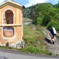
Von Torbole ri. Malcesine --> Straße (249) weiter entlang durch Ortschaft Brenzone bis kl. Ort “Pai” (zwischen Torri del Benaco und Castello di Brenzone) --> dort li. abzweigen ri. Pai di Sopra (Via Manzoni) --> hochfahren bis zum Ort über Pflastersteine --> vorbei an Bar und Pizzeria --> ri. Via Ca. Tronconi (Sackgasse) --> nach ca. 1,5Km kommt eine Brücke --> diese überqueren und am 2. Kirchenbildstock parken auf ca. 250Hm (wenig Platz zum Parken).
approx. 40min
From Torbole ri. Malcesine --> road (249) further along through the village of Brenzone to the small village "Pai" (between Torri del Benaco and Castello di Brenzone) --> there turn left ri. Pai di Sopra (Via Manzoni) --> drive up to the village over cobblestones --> past bar and pizzeria --> ri. Via Ca. Tronconi (dead end) --> after about 1.5Km there is a bridge --> cross it and park at the 2. church iconostasis at about 250Hm (little space for parking).
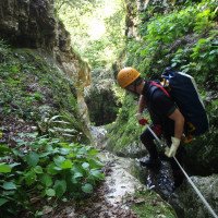
Approche (45 min):
traduction alternative
➜
Langue originale
Vom Parkplatz Straße 15 min folgen Richtung Ca Tronconi> über eine Brücke >vorbei an den Olivenbäume bis zur ersten Häusergruppe --> nach Häusergruppe gleich re. weiter hoch bis zur nächsten Häusergruppe auf ca. 380Hm --> hier ebenfalls re. --> entlang der Steinmauer zuerst gerade dann leicht ansteigend bis zum Bachbett Weg folgen --> Einstieg auf ca. 490Hm.
approx. 45min
From the parking lot follow the road for 15 min in the direction of Ca Tronconi> over a bridge > past the olive trees to the first group of houses --> after the group of houses immediately to the right up to the next group of houses at about 380Hm --> here also to the right --> follow the stone wall first straight then slightly uphill to the streambed path --> entry at about 490Hm.
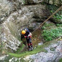
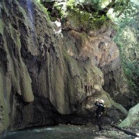
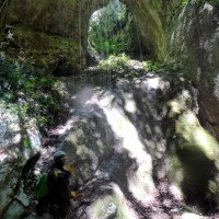
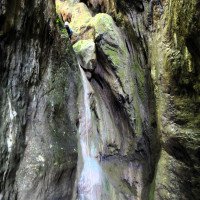
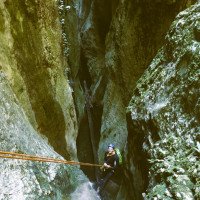
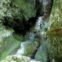
Tour (2 h 30):
traduction alternative
➜
Langue originale
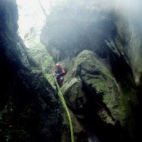
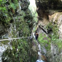
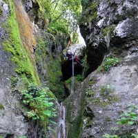
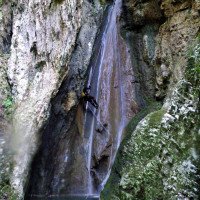
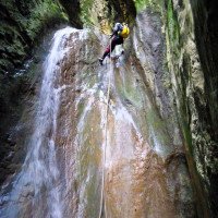
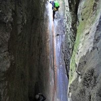
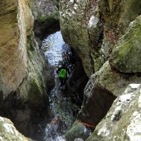
Nach kurzer Gehstrecke kommen schon die ersten Abseilstellen die meist 10 bis 15m hoch sind --> nach ca. 5/6 Abseiler kommt die höchste Abseilstelle mit ca. 35m (! Scharfe Kante!) --> kontinuierlich geht es in enger werdender Schlucht weiter über mehrere Abseilstellen die oft bis 20m hoch sind --> kl. Stellen können mittels Spreiztechnik auch abgeklettert werden --> jedoch ist Vorsicht geboten denn durch die Vegetation gibt es überall rutschige Stellen --> im letzten Drittel wird die Schlucht noch enger und mehrere Abseiler folgen in kurzen Abständen bis zum Schluss --> nach der letzten Abseilstelle geht es über kl. Kletter- und Gehpassagen noch ca. 50m bis zum Ende der Schlucht (Steinmauer).
approx. 3-3,5
After a short walking passages come the first rappel points which are usually 10 to 15m high --> after about 5/6 rappel comes the highest rappel point with about 35m (! Sharp edge!) --> continuously it continues in narrowing canyon over several rappel points that are often up to 20m high --> kl. However, caution is required because the vegetation is everywhere slippery places --> in the last third of the canyon is even narrower and several rappel follow in short intervals to the end --> after the last rappel it goes about small climbing and walking passages about 50m to the exit of the canyon (stone wall).
Retour (10 min):
traduction alternative
➜
Langue originale
An der Steinmauer re. geht man über die Olivenbaumhänge hoch --> in Kürze trifft man auf den Zustiegsweg --> runter zum Parkplatz.
approx. 10min
At the stone wall on the right you go up over the olive tree slopes --> shortly you meet the access path --> down to the parking lot.
Coordonnées:
Départ du Canyon
(cwiki_1)
Fin du Canyon
(cwiki_1)
Parking à l'entrée et à la sortie
45.653596°, 10.726055°
↓↑
DMS: 45° 39" 12.95', 10° 43" 33.8'
DM: 45° 39.216", 10° 43.563"
Google Maps
DMS: 45° 39" 12.95', 10° 43" 33.8'
DM: 45° 39.216", 10° 43.563"
Google Maps
Info canyon ACA
Info canyon Cwiki
Info canyon Descente
Info canyon Ropewiki
Autre info canyon
13.10.2024
Jeroen Kirchner
⭐
★★★★★
📖
★★★
⚓
★★★
💧
Faible
Terminé ✔
pas de traduction disponible
Done a few days after consistent rainfalls. Enjoyable and rather continuous canyon, with 2 escapes we noticed (one before the final waterfall). Anchors are mostly doubled, renewed, a few older ones, but they do the job. Limited parking space, best to come max 1 car.
08.07.2024
Marosffy Dániel
⭐
★★★★★
📖
★★★
⚓
★★★
💧
Faible
Terminé ✔
pas de traduction disponible
One day after a heavy rain the pools were clean and even some water was flowing. We did it without wetsuites that was not too bad. Just a tiny bit.
04.05.2024
MirkoT
⭐
★★★★★
📖
★★★
⚓
★★★
💧
Faible
Terminé ✔
pas de traduction disponible
Automatisch importiert von Descente-Canyon.com für Canyon Sandolino
Sceso oggi con scorrimento basso. All'ingresso c'era scorrimento, cosa non frequente. Era presente schiuma, segno di un ingrossamento d'acqua recente. Armi tutti ok con catene francesi. 4-5 tuffi tutti fattibili.Uno dei migliori avvicinamenti ed uscite dal canyon. Panorama sul lago strepitoso.
(Quelle: https://www.descente-canyon.com/canyoning/canyon-debit/2603/observations.html)
01.11.2023
Marco Heltai
⭐
★★★★★
📖
★★★
⚓
★★★
💧
Normale
Terminé ✔
pas de traduction disponible
Automatisch importiert von Descente-Canyon.com für Canyon Sandolino
(Quelle: https://www.descente-canyon.com/canyoning/canyon-debit/2603/observations.html)
01.11.2023
Mazzoldi
⭐
★★★★★
📖
★★★
⚓
★★★
💧
Faible
Terminé ✔
pas de traduction disponible
Dopo 5 giorni di intensa pioggia, acqua presente che rallegra la discesa. Sconsiglio la discesa in periodi secchi, alcuni armi ancora vecchi che andrebbero rifatti. Il punto di ingresso su questa descrizione è errato, quello reale è a quota 380 m slm, uscita 140 m slm. Ambiente con bellissimo informalmente con belle calate e sempre continue.
https://youtu.be/KQwTnsNPyLY?si=KB0b6YxZ2xTOY0WM
09.03.2023
System User
⭐
★★★★★
📖
★★★
⚓
★★★
pas de traduction disponible
Info: Teile der Canyonbeschreibung wurden automatisiert übernommen. Konkret die Felder Weblinks, Koordinaten, Rating, Ort, Länge des Canyon, Einfachseil Mindestens von https://canyon.carto.net/cwiki/bin/view/Canyons/SandolinoCanyon.html und https://www.descente-canyon.com/canyoning/canyon/2603
09.03.2023
System User
⭐
★★★★★
📖
★★★
⚓
★★★
pas de traduction disponible
Daten importiert von https://www.canyoning.or.at/index.php/liste-aller-canyons/87-vajo-del-sandolino
Nouveau rapport
Veuillez décrire brièvement et de manière concise les informations les plus importantes de la dernière visite ou les informations actuelles importantes sur le canyon. Si nécessaire avec des liens vers des vidéos, photos, etc.
*
*
*
Esc
Del
Hydrologie: