v3 a2 II
4h20
1h
3h
20min
2140m
1920m
220m
26m
1300m
Évaluation:
★★★★★
2.3 (2)
Info:
★★★
0 ()
Belay:
★★★
0 ()
Résumé:
traduction alternative
➜
Langue originale
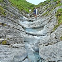
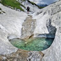
Gletschermühlenwanderung mit einigen Abseilern; auch für Anfänger geeignet
Glacier mill hike with some rappel; also suitable for beginners
Sud
Résumé:
traduction alternative
➜
Langue originale
Gletschermühlenwanderung mit einigen Abseilern; auch für Anfänger geeignet
Glacier mill hike with some rappel; also suitable for beginners
Accès:
traduction alternative
➜
Langue originale
Auf der A 13 vorbei an Chur in Richtung San Bernardino. 6,8 km nach der Autobabahnausfahrt Chur-West (Nr. 17) gabelt sich die Autobahndoppelspur und wir nehmen den rechten Fahrstreifen in Richtung Flims, Disentis. Wir fahren 17,5 km stetig bergan und biegen dann vor dem Tunnel rechts ab nach Trin (880 m üNN). Von hier fahren wir in vielen Serpentinen die teilweise enge Straße/Piste hinauf zur Alp Mora. Auf Höhe 1900 m üNN gabelt sich der Feldweg wieder (geradeaus zur Alpe Tegia Sut, in Winkel nach links weiter aufwärts zur Alp Mora). Hier stellen wir das Auto ab.
Take the A 13 past Chur in the direction of San Bernardino. 6.8 km after the freeway exit Chur-West (No. 17) the freeway double lane forks and we take the right lane in the direction of Flims, Disentis. We drive 17.5 km steadily uphill and then turn right before the tunnel to Trin (880 m above sea level). From here we drive in many serpentines up the partly narrow road/piste to Alp Mora. At 1900 m a.s.l. the dirt road forks again (straight ahead to Alpe Tegia Sut, in the angle to the left further up to Alp Mora). Here we park the car.
Approche (1 h):
traduction alternative
➜
Langue originale
Wir gehen die Piste nach links weiter aufwärts. Bei der zweiten Linkskehre auf Höhe 1975 m üNN folgen wir der Wegweisung zu den "Gletschermühlen" in Richtung ONO. Wir nähern uns dem Bacheinschnitt und auf Höhe 2120 erreicht der Pfad das Bachbett. Von hier kann man noch bachauf bis in den Talschluss laufen und dort noch ca. 20 Höhenmeter den Wiesenhang hinauf.
We continue up the slope to the left. At the second leftward haipin bend at elevation 1975 m a.s.l., we follow the signpost to the "Glacier Mills" in the direction of ONO. We approach the streambed and at altitude 2120 the trail reaches the streambed. From here you can still walk up the stream to the head of the valley and there about 20 meters of altitude up the meadow slope.
Tour (3 h):
traduction alternative
➜
Langue originale
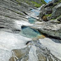
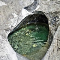
Vor allem zu Beginn schön ausgeschliffene Gletschermühlen. Großartige Landschaft. Reiche Flora. EinigeSchrägabseiler.\nFür die Auffahrt von Trin zur Alp Mora ist Maut zu bezahlen (10 CHFr - 2010). Zahlbar im Gemeindeamt - Keller, Türe links - klopfen !)
Especially at the beginning beautifully polished glacial mills. Great scenic. Rich flora. Some slope ropes.\nFor the ascent from Trin to Alp Mora toll is payable (10 CHFr - 2010). Payable in the municipal office - basement, door on the left - knock !)
Retour (20 min):
traduction alternative
➜
Langue originale
Bei der Steinbrücke rechts hinaus und auf undeutlichem Pfad in westlicher Richtung leicht ansteigend über die Alpe Tegia Sut (1945 m üNN) zurück zum Auto.
At the stone bridge, go out to the right and follow the indistinct path in a westerly direction, slightly ascending over the Alpe Tegia Sut (1945 m a.s.l.) back to the car.
Coordonnées:
Départ du Canyon
46.8586°, 9.3634°
↓↑
DMS: 46° 51" 30.96', 9° 21" 48.24'
DM: 46° 51.516", 9° 21.804"
Google Maps
Suisse Topographique
DMS: 46° 51" 30.96', 9° 21" 48.24'
DM: 46° 51.516", 9° 21.804"
Google Maps
Suisse Topographique
Fin du Canyon
46.8473°, 9.3702°
↓↑
DMS: 46° 50" 50.28', 9° 22" 12.72'
DM: 46° 50.838", 9° 22.212"
Google Maps
Suisse Topographique
DMS: 46° 50" 50.28', 9° 22" 12.72'
DM: 46° 50.838", 9° 22.212"
Google Maps
Suisse Topographique
Littérature:
Carte
CNS 1195, Reichenau, 1 : 25 000
Carte
http://ivs-gis.admin.ch/ (interaktive Karte)
Livre Canyoning
Swiss Alps - Canyoning - Alpes Suisses
Emmanuel Belut / Laurence Boyé / Thomas Guigon
Association Openbach
2015
9782746679450
Livre Canyoning
GRand Canyons. Timo Stammwitz, 2010
Info canyon Cwiki
Info canyon Descente
Info canyon Ropewiki
Info canyon Schlucht.ch
09.03.2023
System User
⭐
★★★★★
📖
★★★
⚓
★★★
pas de traduction disponible
Info: Teile der Canyonbeschreibung wurden automatisiert übernommen. Konkret die Felder Weblinks, Koordinaten, Rating, Länge des Canyon, Einfachseil Mindestens von https://www.descente-canyon.com/canyoning/canyon/22452
09.03.2023
System User
⭐
★★★★★
📖
★★★
⚓
★★★
pas de traduction disponible
Daten importiert von https://canyon.carto.net/cwiki/bin/view/Canyons/MaliensCanyon.html
Hydrologie:


