un peu difficile
Val Tür
v4 a3 III
2h25
15min
2h
10min
830m
640m
190m
80m
2x 80m
5
680m
Voiture facultative
Évaluation:
★★★★★
3 (7)
Info:
★★★
2.6 (7)
Belay:
★★★
2.1 (7)
Résumé:
traduction alternative
➜
Langue originale
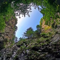
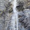
Kurze, recht vertikale Schlucht mit 110 m Finale (30 /80)
Short, quite vertical canyon with 110 m final (30 /80)
juin - octobre
Ouest
5.70km²
Résumé:
traduction alternative
➜
Langue originale
Kurze, recht vertikale Schlucht mit 110 m Finale (30 /80)
Short, quite vertical canyon with 110 m final (30 /80)
Accès:
pas de traduction disponible
A13 Ausfahrt 15 (Zizers). Weiter nach Trimmis. Parkmöglichkeiten Nähe Trimmis Platz. Dort 1 PKW abstellen. Mit dem 2 PKW weiter Richtung Says bis Valtanna.
Approche (15 min):
pas de traduction disponible
Dem Wanderweg in Richtung Talein folgen (Schild), vorbei an einer großen Wiese. Am Ende der Wiese in Höhe eines Gebäudes dem Wanderweg rechts nach unten zum Fluss folgen. Der Weg quert den Fluss und folgt ihm bis zur ersten Geschiebebremse. Hier einsteigen.
Tour (2 h):
traduction alternative
➜
Langue originale
Fünf Abseiler, davon 2 an Staustufen, einige eher kleine Rutschen. Auch geologisch schöne Schlucht, schönes Gestein.
Highlight ist der c110 getrennt in zwei Stufen 30 und 80 Meter.
Some rappels and slides. Also geologically beautiful canyon, beautiful rock.
Highlight is the c110 separated into two steps of 30 and 80 meters.
Retour (10 min):
pas de traduction disponible
Am Mühlenweg die Schlucht verlassen. Wenige Meter bis Trimmis Platz
Coordonnées:
Départ du Canyon
46.8959°, 9.57463°
↓↑
DMS: 46° 53" 45.24', 9° 34" 28.67'
DM: 46° 53.754", 9° 34.478"
Google Maps
Suisse Topographique
DMS: 46° 53" 45.24', 9° 34" 28.67'
DM: 46° 53.754", 9° 34.478"
Google Maps
Suisse Topographique
Parking à la sortie
46.8994°, 9.56652°
↓↑
DMS: 46° 53" 57.84', 9° 33" 59.47'
DM: 46° 53.964", 9° 33.991"
Google Maps
Suisse Topographique
DMS: 46° 53" 57.84', 9° 33" 59.47'
DM: 46° 53.964", 9° 33.991"
Google Maps
Suisse Topographique
Parking à l'entrée
46.8994°, 9.57477°
↓↑
DMS: 46° 53" 57.84', 9° 34" 29.17'
DM: 46° 53.964", 9° 34.486"
Google Maps
Suisse Topographique
DMS: 46° 53" 57.84', 9° 34" 29.17'
DM: 46° 53.964", 9° 34.486"
Google Maps
Suisse Topographique
Fin du Canyon
46.89834°, 9.566°
↓↑
DMS: 46° 53" 54.02', 9° 33" 57.6'
DM: 46° 53.9", 9° 33.96"
Google Maps
Suisse Topographique
DMS: 46° 53" 54.02', 9° 33" 57.6'
DM: 46° 53.9", 9° 33.96"
Google Maps
Suisse Topographique
Parking à la sortie
46.898458°, 9.564808°
↓↑
DMS: 46° 53" 54.45', 9° 33" 53.31'
DM: 46° 53.907", 9° 33.888"
Google Maps
Suisse Topographique
DMS: 46° 53" 54.45', 9° 33" 53.31'
DM: 46° 53.907", 9° 33.888"
Google Maps
Suisse Topographique
Alternative
25.01.2025
Alex Engelhardt
⭐
★★★★★
📖
★★★
⚓
★★★
💧
Faible
Terminé ✔
traduction alternative
➜
Langue originale
Zustieg easy zu Fuss. 45min. Kein Eis mehr bei 15 Grad plus und Fön. Alle Haken da. Nix Aussergewöhnliches. Schöne Schluss Sequenz. 2h15 Auto zu Auto entspanntes Tempo
Easy access on foot. 45 minutes. No more ice at 15 degrees plus and hair dryer. All anchors there. Nothing out of the ordinary. Nice final sequence. 2h15 car to car relaxed pace
06.01.2025
Airmax
⭐
★★★★★
📖
★★★
⚓
★★★
💧
Faible
Terminé ✔
traduction alternative
➜
Langue originale
Alle Haken vorhanden. Kaum Eis im Bach. Der C80 sind wohl eher 70m.
All anchors available. Hardly any ice in the stream. The C80 is probably more like 70m.
06.10.2024
Nico Schneider
⭐
★★★★★
📖
★★★
⚓
★★★
💧
Normale
Terminé ✔
traduction alternative
➜
Langue originale
D'autres utilisateurs ont été: Isabella Rosenau
Alle Haken sind noch vorhanden.
Momentan ist die Schlucht sehr griffig.
All anchors are still there.
At the moment the canyon is very grippy.
D'autres utilisateurs ont été: Isabella Rosenau
29.09.2024
Emi
⭐
★★★★★
📖
★★★
⚓
★★★
💧
Haut
Terminé ✔
traduction alternative
➜
Langue originale

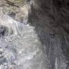


Recht sportlicher Wasserstand.
Nicht unmöglich da selten durch den Hauptwasserstrahl. Die Hauptgefahr sind die Steine, die das Wasser mitschleppt. Da ein bisschen Acht geben.
Orografisch rechter Zwischenstand beim großen Abseiler beschädigt, weshalb wir den linken genommen haben.
Ans. Relativ gute Stände allerdings etwas locker. Schlüssel zum Nachziehen ist fast ein Muss. Hatten wir auch dabei und die benutzen Stände nachgezogen.
Quite sporty water level.
Not impossible as rarely through the main water jet. The main danger is the stones that the water drags along. Take a little care there.
Orographic right intermediate belay damaged during the big rappel, which is why we took the left one.
Ans. Relatively good stances but a bit loose. A wrench for retightening is almost a must. We also had it with us and tightened the stances we used.
19.09.2024
Christoph Cramer
⭐
★★★★★
📖
★★★
⚓
★★★
💧
Normale
Terminé ✔
traduction alternative
➜
Langue originale
D'autres utilisateurs ont été: Patrick Klarner
Landschaftlich schöne kurze Tour mit spektakulärem Schlusswasserfall. Alle Stände in Ordnung und meist als doppelte Expansionsanker mit Ring ausgeführt.
Scenic short tour with spectacular final waterfall. All belays in good order and mostly designed as double expansion anchors with a ring.
D'autres utilisateurs ont été: Patrick Klarner
14.10.2023
Inga
⭐
★★★★★
📖
★★★
⚓
★★★
💧
Faible
Terminé ✔
traduction alternative
➜
Langue originale
Alles ok.
Stellenweise ein paar Anker zu viel...
Mit Seilklemmer in 1:15 durch
Everything ok.
In places a few anchors too much...
With rope jam in 1:15 through
01.10.2023
Christian Balla
⭐
★★★★★
📖
★★★
⚓
★★★
💧
Normale
Terminé ✔
traduction alternative
➜
Langue originale
Sehr schöner canyon. Video zur Tour: https://www.youtube.com/watch?v=KAMqLhS10W8
Very beautiful canyon. Video of the tour: https://www.youtube.com/watch?v=KAMqLhS10W8
Nouveau rapport
Veuillez décrire brièvement et de manière concise les informations les plus importantes de la dernière visite ou les informations actuelles importantes sur le canyon. Si nécessaire avec des liens vers des vidéos, photos, etc.
*
*
*
Esc
Del
Hydrologie: