Pays:
Schweiz / Switzerland
Région: Kanton Wallis / Canton du Valais
Sous-régione: Bezirk Leuk
Ville: Leukerbad
v4 a4 III
5h45
1h40
4h
5min
2120m
1650m
470m
17m
2x 20m
2800m
à pied
Évaluation:
★★★★★
3.5 (3)
Info:
★★★
2 (2)
Belay:
★★★
2 (2)
Résumé:
traduction alternative
➜
Langue originale
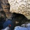
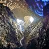
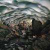
Langer und wasserreicher Abseilcanyon mit insgesamt von einander getrennten Abschnitten, gespeist von Gletscherwasser
Infos+topos: f-betri@bluewin.ch
Long and watery rappel canyon with parts altogether separated from each other, fed by glacial water
Info+topos: f-betri@bluewin.ch
12.40km²
Résumé:
traduction alternative
➜
Langue originale
Langer und wasserreicher Abseilcanyon mit insgesamt von einander getrennten Abschnitten, gespeist von Gletscherwasser
Infos+topos: f-betri@bluewin.ch
Long and watery rappel canyon with parts altogether separated from each other, fed by glacial water
Info+topos: f-betri@bluewin.ch
Accès:
traduction alternative
➜
Langue originale
Von der "9" im Rhônetal bei Leuk abfahren und hinauf nach Leukerbad. Auf dem Parkplatz an der Dala - Brücke am nördlichen Ortsende das Auto abstellen (Parkgebühr !). Siehe Anfahrt und Ortsplan Leukerbad in Fotogalerie.
Leave the "9" in the Rhône valley at Leuk and drive up to Leukerbad. Park your car in the parking lot at the Dala bridge at the northern end of the village (parking fee!). See approach and map of Leukerbad in photo gallery.
Approche (1 h 40):
traduction alternative
➜
Langue originale
Vom Parkplatz P zum Einstieg E siehe Karte 1 sowie Einstieg I Luftbild in Fotogalerie.
From parking lot P to entry E see map 1 and entry I aerial photo in photo gallery.
Tour (4 h):
traduction alternative
➜
Langue originale
Im Dala amont 2 räumlich voneinander getrennte Canyonabschnitte. Abschnitt I nur etwa 200m lang, aber eng und tief eingeschnitten. Dann etwa 1300m Laufstrecke in offenem Bachbett bis zum Beginn des Abschnitts II. Hier einige Abseiler mit sportlicher Note. Nach Schluchtöffnung wieder etwa 500m Laufstrecke, dann Ausstieg A auf den Weg bei der Brücke (siehe Luftaufnahmen).
In the Dala amont 2 spatially separated canyon sections. Section I only about 200m long, but narrow and deep cut. Then about 1300m run in open streambed to the beginning of part II. Here some rappel with a sporty touch. After canyon opening again about 500m run, then exit A on the trail by the bridge (see aerial photos).
Retour (5 min):
traduction alternative
➜
Langue originale
Den Weg am rechten Ufer der Dala hinunter nach Leukerbad und zum Parkplatz.
The path along the right bank of the Dala down to Leukerbad and the parking lot.
Coordonnées:
Départ du Canyon
46.4036°, 7.67886°
↓↑
DMS: 46° 24" 12.96', 7° 40" 43.9'
DM: 46° 24.216", 7° 40.732"
Google Maps
Suisse Topographique
DMS: 46° 24" 12.96', 7° 40" 43.9'
DM: 46° 24.216", 7° 40.732"
Google Maps
Suisse Topographique
Fin du Canyon
46.3899°, 7.6532°
↓↑
DMS: 46° 23" 23.64', 7° 39" 11.52'
DM: 46° 23.394", 7° 39.192"
Google Maps
Suisse Topographique
DMS: 46° 23" 23.64', 7° 39" 11.52'
DM: 46° 23.394", 7° 39.192"
Google Maps
Suisse Topographique
Parking à l'entrée et à la sortie
46.38233°, 7.63217°
↓↑
DMS: 46° 22" 56.39', 7° 37" 55.81'
DM: 46° 22.94", 7° 37.93"
Google Maps
Suisse Topographique
DMS: 46° 22" 56.39', 7° 37" 55.81'
DM: 46° 22.94", 7° 37.93"
Google Maps
Suisse Topographique
Fin alternative du canyon
46.385336°, 7.637579°
↓↑
DMS: 46° 23" 7.21', 7° 38" 15.28'
DM: 46° 23.12", 7° 38.255"
Google Maps
Suisse Topographique
DMS: 46° 23" 7.21', 7° 38" 15.28'
DM: 46° 23.12", 7° 38.255"
Google Maps
Suisse Topographique
Im Bach weiter bis hier, dann orographisch links auf den Wanderweg und zum Auto.
Littérature:
Carte
1:25000
Livre Canyoning
Emmanuel Belut / Laurence Boyé / Thomas Guigon
Association Openbach
2015
9782746679450
Info canyon Cwiki
Info canyon Descente
Info canyon Ropewiki
18.01.2025
Alex Arnold
⭐
★★★★★
📖
★★★
⚓
★★★
💧
Normale
Terminé ✔
traduction alternative
➜
Langue originale
Dala 4 zum Frühstück. Etwas Eis aber gut machbar
Dala 4 for breakfast. Some ice cream but doable
15.11.2024
Jeanne
⭐
★★★★★
📖
★★★
⚓
★★★
💧
Normale
Terminé ✔
pas de traduction disponible
Automatisch importiert von Descente-Canyon.com für Canyon Dala amont (I+II)
La partie 1 et 2 ont pu être ré-équipées partiellement mais il reste quelque portions de désescalade peu agréables car la partie 2 est très glissante (et pas que à cause de la glace). Partie 3 et 4 non parcourues, l'eau était brune à ce moment là.
(Quelle: https://www.descente-canyon.com/canyoning/canyon-debit/23865/observations.html)
02.11.2024
EspritCanyon
⭐
★★★★★
📖
★★★
⚓
★★★
💧
Normale
Terminé ✔
pas de traduction disponible
Automatisch importiert von Descente-Canyon.com für Canyon Dala amont (I+II)
Le canyon a du beaucoup changé ces derniers temps. Beaucoup de ressauts sans équipements, à d'autres endroits il y a des ancrages qui ne servent à rien (spécialement dans la 1ere partie) .Nous sommes sortis en rive gauche dans la 2e partie avant les grands rappels. Puis , en voulant reprendre la descente dans la 3e partie, il n'y avait toujours pas d'ancrage et un débit conséquent, nous avons renoncer à la descente. Il faudra revoir complètement l'équipement pour les prochains. Actuellement,Je déconseille d'y aller.L équipement de la partie 4 semble correct.
(Quelle: https://www.descente-canyon.com/canyoning/canyon-debit/23865/observations.html)
27.10.2024
Lobster_quentinmaxime_b
⭐
★★★★★
📖
★★★
⚓
★★★
💧
Normale
Terminé ✔
pas de traduction disponible
Automatisch importiert von Descente-Canyon.com für Canyon Dala amont (I+II)
On a rajouté un un point avant une C7 ou le relais était assez loin hors crue dans le dernier encaissement
(Quelle: https://www.descente-canyon.com/canyoning/canyon-debit/23865/observations.html)
14.01.2024
alex.arnold
⭐
★★★★★
📖
★★★
⚓
★★★
💧
Normale
Terminé ✔
pas de traduction disponible
Automatisch importiert von Descente-Canyon.com für Canyon Dala amont (I+II)
Only did dala 4. Anchors ok now
(Quelle: https://www.descente-canyon.com/canyoning/canyon-debit/23865/observations.html)
08.12.2023
Gautama108
⭐
★★★★★
📖
★★★
⚓
★★★
💧
Normale
Terminé ✔
pas de traduction disponible
Automatisch importiert von Descente-Canyon.com für Canyon Dala amont (I+II)
Dala IV. DC+. Parcouru de nuit. Approche dans la neige. Glace sur les bords. MAGIQUE !!!Attention. Le canyon a changé. Un nouveau ressaut (4-5m) est apparu et certains amarrages sont 6-8 m trop haut. On a pu s'en sortir avec des AN, mais prévoir de quoi équiper ...
(Quelle: https://www.descente-canyon.com/canyoning/canyon-debit/23865/observations.html)
09.03.2023
System User
⭐
★★★★★
📖
★★★
⚓
★★★
pas de traduction disponible
Info: Teile der Canyonbeschreibung wurden automatisiert übernommen. Konkret die Felder Weblinks, Koordinaten, Rating, Länge des Canyon, Einfachseil Mindestens von https://www.descente-canyon.com/canyoning/canyon/23865
09.03.2023
System User
⭐
★★★★★
📖
★★★
⚓
★★★
pas de traduction disponible
Daten importiert von https://canyon.carto.net/cwiki/bin/view/Canyons/DalaCanyon.html
25.10.2021
Bubtore
⭐
★★★★★
📖
★★★
⚓
★★★
💧
Normale
Terminé ✔
traduction alternative
➜
Langue originale

In dem Jahr gab es bis zu einem Kilometer langen Tunnel im Lawinenschnee, einfach nur wow!
That year there were tunnels up to a kilometer long in avalanche snow, just wow!
Nouveau rapport
Veuillez décrire brièvement et de manière concise les informations les plus importantes de la dernière visite ou les informations actuelles importantes sur le canyon. Si nécessaire avec des liens vers des vidéos, photos, etc.
*
*
*
Esc
Del
Hydrologie:


