Paese:
Italia / Italy
Regione: Marche
Sottoregione: Pesaro e Urbino
Città: Piobbico, Acquanera, Rocca Leonella
v3 a2 III
2h
20min
1h30
10min
710m
510m
200m
18m
2x20m
12
500m
Valutazione:
★★★★★
3 (4)
Info:
★★★
2.5 (2)
Belay:
★★★
2.5 (2)
Sintesi:
traduzione alternativa
➜
Lingua originale
Kurzer, homogener, Abseilcanyon mit schönen Felsformationen.
Short, homogeneous, rappel canyon
Nord
Sintesi:
traduzione alternativa
➜
Lingua originale
Kurzer, homogener, Abseilcanyon mit schönen Felsformationen.
Short, homogeneous, rappel canyon
Accesso:
traduzione alternativa
➜
Lingua originale
Über die A-14, vorbei an Cattólica und Pesaro bis zur Ausfahrt bei Fano. Weiter auf der SS-3 und nach 39 km diese verlassen und auf der SS-257 in westlicher Richtung nach Pióbbico fahren (17 km). Etwa 1 km vor Pióbbico biegt man in südlicher Richtung ab auf die Straße nach Secchiano und Cagli. Nach einem weiteren Kilometer passiert man kurz nach dem Weiler Acquanera die Abzweigung zum Monte Nerone, fährt hier aber geradeaus und erreicht einige hundert Meter weiter auf einem Sattel den kleinen ummauerten Friedhof von Rocca Leonella.Hier beginnt der Zustieg. Das Auto parkt man ca. 1 km weiter - vorbei an einer Quellfassung - auf der Straße nach Rocca Leonella an der Brücke über den Presale. (kommt man von Secchiano sind es ab dem Abzweig bis zur Brücke genau 9,7 km)
Take the A-14, pass Cattólica and Pesaro until the exit at Fano. Continue on the SS-3 and after 39 km leave it and go west on the SS-257 to Pióbbico (17 km). About 1 km before Pióbbico turn south on the road to Secchiano and Cagli. After another kilometer, just after the hamlet of Acquanera, you pass the turnoff for Monte Nerone, but go straight on here and a few hundred meters further on, on a saddle, you reach the small walled cemetery of Rocca Leonella.This is where the access begins. Park the car about 1 km further on - past a spring - on the road to Rocca Leonella at the bridge over the Presale. (if you come from Secchiano, it is exactly 9.7 km from the junction to the bridge).
Avvicinamento (20 min):
traduzione alternativa
➜
Lingua originale
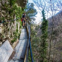
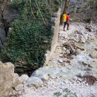
Vom Friedhof auf dem Wanderweg Nr. 13 in südwestlicher Richtung gehen, immer leicht und gleichmäßig ansteigend erreicht man in ca. 20 Min. einen Eisensteg, der über der Schlucht eine Felswand passiert.Wer dem baulichen Zustand dieses Stegs - mit Recht - skeptisch gegenübersteht (2019 mit großer Vorsicht begehbar), kann von dem als Einstieg markierten Kettenstand an dem Felsen kurz vor dem Steg in die Schlucht abseilen, müßte dazu aber wohl Seil für eine Abseilfahrt von 30-40 m (geschätzt) mitbringen. Andernfalls tastet man sich vorsichtig über den Steg und hält dann unmittelbar links hinunter in das Bachbett des Presale bei einem mächtigen alten, aber verfallenen Wehrbauwerk. Hier ist die 1. Abseilstelle von einem kleinen Bäumchen.
From the cemetery, take trail no. 13 in a southwesterly direction, always climbing gently and steadily, and in about 20 minutes you will reach an iron footbridge that passes a rock face above the canyon. If you are skeptical - and rightly so - about the structural condition of this footbridge (which has since been boarded up - 2007), you can rappel into the canyon from the chain anchor marked as the entry point on the rock just before the footbridge, but you will probably have to bring ropes for a rappel of 30-40 m (estimated). Otherwise, carefully feel your way over the footbridge and then keep immediately left down into the streambed of the Presale at a mighty old but dilapidated weir structure. Here is the 1st rappel point from a small tree.
Giro (1 h 30):
traduzione alternativa
➜
Lingua originale
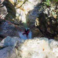
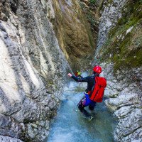
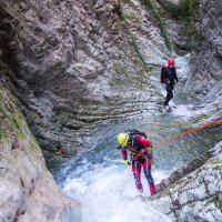
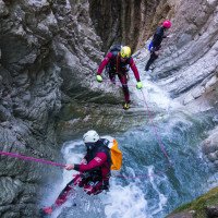
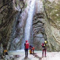
12 Abseiler, wenige niedrige Sprungmöglichkeiten. Interessante Felsformationen im schräg gebankten Kalk.
12 rappels, some possible jumps
Ritorno (10 min):
traduzione alternativa
➜
Lingua originale
Am Ende ändert sich die Gesteinsart (roter Schiefer). Man steigt die letzten kleinen Stufen in diesem Gestein ab und geht etwa 100 m im Bach. Kurz vor der Brücke ist der Ausstieg mit roter Farbe und einem kleinen Schild markiert.Auch 50 m nach Unterquerung der Straßenbrücke ist der Ausstieg links hinauf zur Straße möglich.
At the exit the type of rock changes (red slate). You descend the last small steps in this rock and walk about 100 m in the stream. Just before the bridge, the exit is marked with red paint and a small sign.Also 50 m after passing under the road bridge, the exit is possible on the left up to the road.
Coordinate:
Inizio del canyon
Fine del canyon
Partenza alternativa del canyon
(descente_1)
Parcheggio all'entrata
(descente_3)
Parcheggio in uscita
(descente_4)
Letteratura:
Mappa
IGMI 25/V - 116 Pianello IV-SO, 1 25.000
Libro Canyoning
Profonde Gole
Michele Sivelli / Mario Vianelli
1988
Libro Canyoning
Gole & Canyons. 1- Italia Centrale
Valerio Carlin / Tullio Dobosz / Giorgio Ecker / Annamaria Pinotti / Roberto Recchioni
1998
Libro Canyoning
Figlie dell´acqua e del tempo. Gole, forre e castate dell´Appennino Centrale
Giuseppe Antonini
2001
Libro Canyoning
Le tour de l´Europe en Canyon. T2 - Ligurie, Italia centrale et du sud, Sicile, Sardaigne, Balkans....
Stéphane Coté / Caracal et les Sancho Panza
2009
Info sul canyon Cwiki
Info sul canyon Descente
Info sul canyon Ropewiki
Sconosciuto
Altro info sul canyon
Altro info sul canyon
Rapporto di viaggio (ad es. blogpost)
Altro info sul canyon
04.11.2024
guigui
⭐
★★★★★
📖
★★★
⚓
★★★
💧
Normale
Completato ✔
nessuna traduzione disponibile
Automatisch importiert von Descente-Canyon.com für Canyon Presale
Très mignon et continu. Équipement parfait. 1h40 de voiture à voiture sans navette
(Quelle: https://www.descente-canyon.com/canyoning/canyon-debit/21123/observations.html)
02.06.2024
Péter Bonczi
⭐
★★★★★
📖
★★★
⚓
★★★
💧
Normale
Completato ✔
traduzione alternativa
➜
Lingua originale
Minden oké. Jól felszerelt.
All is well. Well equipped.
19.05.2024
Fabrizio Cavazzuti
⭐
★★★★★
📖
★★★
⚓
★★★
💧
Normale
Completato ✔
nessuna traduzione disponibile
Automatisch importiert von Descente-Canyon.com für Canyon Presale
(Quelle: https://www.descente-canyon.com/canyoning/canyon-debit/21123/observations.html)
09.03.2023
System User
⭐
★★★★★
📖
★★★
⚓
★★★
nessuna traduzione disponibile
Info: Teile der Canyonbeschreibung wurden automatisiert übernommen. Konkret die Felder Weblinks, Koordinaten, Rating, Länge des Canyon, Einfachseil Mindestens von https://www.descente-canyon.com/canyoning/canyon/21123
09.03.2023
System User
⭐
★★★★★
📖
★★★
⚓
★★★
nessuna traduzione disponibile
Daten importiert von https://canyon.carto.net/cwiki/bin/view/Canyons/PresaleCanyon.html
11.03.2019
GeorgB
⭐
★★★★★
📖
★★★
⚓
★★★
💧
Normale
Completato ✔
traduzione alternativa
➜
Lingua originale
Freundliche Tour. Am Zustieg tote Stachelschweine gesehen. Stahlsteg gerade noch begehbar.
Friendly tour. Saw dead porcupines on the approach. Steel footbridge still just passable.
Idrologia:
