un po' difficile
Seinsbachklamm
Paese:
Deutschland / Germany
Regione: Oberbayern / Upper Bavaria
Sottoregione: Landkreis Garmisch-Partenkirchen
Città: Mittenwald
v4 a4 III
1h45
30min
1h10
5min
970m
900m
70m
12m
1x30m
5
a piedi
Valutazione:
★★★★★
3.6 (3)
Info:
★★★
2.5 (2)
Belay:
★★★
2.5 (2)
Sintesi:
traduzione alternativa
➜
Lingua originale
Kurzer, aber abwechslungsreicher Abstieg, der bei ordentlich Wasserdurchsatz geübten Canyonisten vorbehalten ist.
Short but varied descent, which is reserved for experienced canyonists with a good flow of water.
Parti
Sintesi:
traduzione alternativa
➜
Lingua originale
Kurzer, aber abwechslungsreicher Abstieg, der bei ordentlich Wasserdurchsatz geübten Canyonisten vorbehalten ist.
Short but varied descent, which is reserved for experienced canyonists with a good flow of water.
Accesso:
traduzione alternativa
➜
Lingua originale
Von Garmisch-Partenkirchen (Ortsmitte, zentrale Kreuzung) 17,4 km auf der B 2 in Richtung Mittenwald, Innsbruck. Auf Höhe des Campingplatzes Isarhorn biegen wir vor der (zweiten) Brücke über die Isar von der B 2 links ab, nehmen das zweite Strässchen nach links in Richtung Ferein-Alm und fahren am orograf. rechten Seinsbachufer 300 m in Richtung NO. Bei der nächsten Forstwegeverzweigung finden wir reichlich Platz zum Parken.\n
From Garmisch-Partenkirchen (town center, central intersection) 17.4 km on the B 2 in the direction of Mittenwald, Innsbruck. At the Isarhorn campsite, turn left off the B 2 before the (second) bridge over the Isar, take the second small road to the left in the direction of Ferein-Alm and follow the orographic right bank of the Seinsbach for 300 m in a northerly direction. There is plenty of space to park at the next fork in the forest road.\n
Avvicinamento (30 min):
traduzione alternativa
➜
Lingua originale
Auf der Forststraße weiter Richtung Ferein-Alm. Nach etwa 25 Min. und 900 m Wegstrecke nehmen wir den Forstweg nach rechts in Richtung Aschaualm, Mittenwald und kommen nach weiteren 5 Min. an den Seinsbach.
Continue along the forest road towards Ferein-Alm. After about 25 minutes and 900 m we take the forest road to the right in the direction of Aschaualm, Mittenwald and after another 5 minutes we reach the Seinsbach.
Giro (1 h 10):
traduzione alternativa
➜
Lingua originale
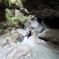
Nach etwa 150 m im offenen Bachbett kommen wir zu den ersten Gumpen und dem ersten Abseiler (re. 4 m, meist rutschbar). Nach einigen weiteren Gumpen und einer kleinen Rutsche gehen wir durch einen engen und ca. 50 m langen Korridor. Es folgt ein offener Schluchtteil, an dessen Ende sich rechts hinauf eine Ausstiegsmöglichkeit eröffnet.
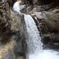
Nun beginnt das Kernstück mit zwei Abseilern in Gumpen, die nur dann problemlos sind, wenn man auf dem Grund stehen kann (Ende Juli 2018 völlig aufgekiest). Es folgt der letzte und höchste Abseiler (12m+5m "Anlauf"), bei dem man sich am rechten Stand in eine Führungsleine einklinken kann (langen Teil der Sicherungsleine nehmen !), um sich weitgehend aus dem druckvollen Strahl herauszuhalten.
Links findet sich ein nicht ganz einfach zugänglichen Stand, von dem man trocken abseilen kann (12m).
Wo sich die Schlucht öffnet, kann man rechts auf den Forstweg aussteigen oder man geht vorher noch etwas weiter durch die kleine Konglomeratschlucht.
After about 150 m in the open streambed, we come to the first pools and the first rappel (right 4 m, mostly slippable). After a few more pools and a small slide, we go through a narrow corridor about 50 m long. This is followed by an open part of the gorge, at the exit of which an exit option opens up on the right.
Now the core section begins with two rappels into pools, which are only easy if you can stand on the ground (completely gravelled up at the end of July 2018). This is followed by the last and highest rappel (12m+5m "run-up"), where you can clip into a guide line on the right (take the long part of the safety line!) to stay out of the powerful jet.
On the left there is a not easily accessible belaystation from which you can rappel dry (12m).
Where the canyon opens up, you can exit to the right onto the forest path or continue a little further through the small conglomerate gorge.
Ritorno (5 min):
traduzione alternativa
➜
Lingua originale
Rechts hinaus zur Forststraße und auf dieser zum Auto.
Turn right to the forest road and follow it to the car.
Coordinate:
Inizio del canyon
Fine del canyon
Parcheggio Entrata e uscita
47.47504°, 11.28049°
↓↑
DMS: 47° 28" 30.14', 11° 16" 49.76'
DM: 47° 28.502", 11° 16.829"
Google Maps
DMS: 47° 28" 30.14', 11° 16" 49.76'
DM: 47° 28.502", 11° 16.829"
Google Maps
Letteratura:
Mappa
8533/8633 Mittenwald (TK25) - 1/25000
Mappa
http://geoportal.bayern.de/bayernatlas?base=910 (Gewässer: Seinsbach)
Libro Canyoning
Canyoning in Bayern und Tirol (2. Auflage)
Werner Baumgarten
2013
Libro Canyoning
Canyons in Europa. 50 Touren für Schluchten-wanderer, Canyon-Trekker und Wildwasser-fahrer
Alfons Zaunhuber
Berg im Südwest Verlag
1994
978-3763411078
Libro Canyoning
Canyoning in Bayern und Tirol
Werner Baumgarten
2010
Info sul canyon Cwiki
Info sul canyon Descente
Info sul canyon Ropewiki
29.03.2024
Max
⭐
★★★★★
📖
★★★
⚓
★★★
💧
Alto
Completato ✔
traduzione alternativa
➜
Lingua originale
Alles tip top! Becken beim vorvorletzten Abseiler ist jetzt tief!
Everything is tip top! The pool at the penultimate rappel is now deep!
24.09.2023
Ralf Breitenstein
⭐
★★★★★
📖
★★★
⚓
★★★
💧
Alto
Completato ✔
traduzione alternativa
➜
Lingua originale
Baumstamm direkt im oberen Teil, daher aufgrund des Wasserstandes über Baum links abgeseilt um an den ersten kleinen Abseiler zu gelangen.
Seil am letzten Abseiler schon länger nicht mehr vorhanden, war aber auch nicht erforderlich.
Kurzer Canyon der trotzdem immer wieder Freude macht :)
Parkplatzgebühr fällig (>2h Parkzeit). Nur Münzen ohne Wechselfunktion (6,50 €), alternativ EasyPark-App. Aktuell wohl mit App günstiger (5,29 €)...
Tree trunk directly in the upper part, therefore, due to the water level abseiled over tree left to get to the first small rappel.
Rope on the last rappel has not existed for some time, but was also not necessary.
Short canyon which nevertheless always makes fun :)
Parking fee due (>2h parking time). Only coins without exchange function (6.50 €), alternatively EasyPark app. Currently probably cheaper with app (5.29 €)...
09.03.2023
System User
⭐
★★★★★
📖
★★★
⚓
★★★
nessuna traduzione disponibile
Daten importiert von https://canyon.carto.net/cwiki/bin/view/Canyons/SeinsbachklammCanyon.html
Idrologia:


