non così difficile
Kaputas
v3 a2 III
5h25
15min
5h
10min
625m
15m
610m
27m
2x30m
27
2700m
Auto facoltativa
Valutazione:
★★★★★
3.2 (3)
Info:
★★★
0 ()
Belay:
★★★
2 (1)
Sintesi:
traduzione alternativa
➜
Lingua originale
Abseilcanyon mit Laufpassagen, im Bereich der Einschluchtung meist ohne Wasserdurchsatz. Durchgehender Wasserdurchsatz kann zu Jahresbeginn bis etwa März/April erwartet werden.
Rappel canyon with walking passages, mostly without water flow in the gorge area. Continuous water flow can be expected at the beginning of the year until around March/April.
Sud
Calcare
Sintesi:
traduzione alternativa
➜
Lingua originale
Abseilcanyon mit Laufpassagen, im Bereich der Einschluchtung meist ohne Wasserdurchsatz. Durchgehender Wasserdurchsatz kann zu Jahresbeginn bis etwa März/April erwartet werden.
Rappel canyon with walking passages, mostly without water flow in the gorge area. Continuous water flow can be expected at the beginning of the year until around March/April.
Accesso:
traduzione alternativa
➜
Lingua originale
Autoumsetzung angezeigt. Ein Fahrzeug unten am Kaputas-Strand zwischen Kas und Kalkan. Das zweite Autoüber Kalkan auf der Straße 07-53 in Richtung Elmali. Nach 6,1 km ab Kalkan, vorbei an einem Brunnen rechts der Straße, Auto auf einer Freifläche am Straßenrand und über dem Fluss abstellen.
Zur Umsetzstrecke (13,5 km)siehe http://www.wikiloc.com/wikiloc/view.do?id=13938225
Shuttle displayed. One car down at Kaputas beach between Kas and Kalkan. The second car above Kalkan on road 07-53 towards Elmali. After 6.1 km from Kalkan, past a fountain on the right-hand side of the road, park your car in an open space at the side of the road and above the river.
For the transfer route (13.5 km)see http://www.wikiloc.com/wikiloc/view.do?id=13938225
Avvicinamento (15 min):
traduzione alternativa
➜
Lingua originale
Von der Straße zunächst weglos hinunter zum Fluss stoßen wir auf einen parallel zum Hang verlaufenden Pfad. Auf diesem über dem Fluss abwärts, bis er sich schließlich in das Flussbett herabwindet (bei einer Rohrleitung, die hier den Fluss quert).
From the road, initially without a path down to the river, we come across a path running parallel to the slope. Follow this downhill above the river until it finally winds down into the river bed (near a pipeline that crosses the river here).
Giro (5 h):
traduzione alternativa
➜
Lingua originale
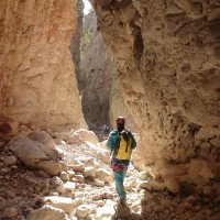
Zunächst im offenen Flussbett, das zu Beginn in aller Regel noch Wasser führt. Schon nach wenigen Minuten versickert das Wasser im Untergrund und der weitere Abstieg erfolgt - von einem umkletterbaren kleinen, aber tiefen Gumpen einmal abgesehen - im Trockenen. Erst nach einer Marschstrecke von rund 1,5 Stunden und einigen Passagen zum Abklettern stoßen wir auf den ersten zwingenden Abseiler. Die Schlucht kerbt sich zusehends ein und gewinnt in selbem Maße an Attraktivität.
27 Abseiler sind zu erledigen. Bei http://www.wikiloc.com/wikiloc/view.do?id=13937747 sind sie einzeln bis in's Detail aufgelistet .
First in the open riverbed, which usually still has water at the beginning. After just a few minutes, the water seeps into the ground and the descent continues - apart from a small but deep pool that can be climbed around - in the dry. Only after a walk of around 1.5 hours and a few passages for downclimbing do we come across the first compelling rappel. The canyon becomes more and more notchy and becomes more and more attractive.
There are 27 rappels to complete. They are listed in detail at http://www.wikiloc.com/wikiloc/view.do?id=13937747.
Ritorno (10 min):
traduzione alternativa
➜
Lingua originale
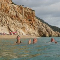
Nach dem attraktiven 27. und letzten Abseiler (27m) laufen wir einige wenige Minuten weiter, überklettern die Mauer einer Wasserableitung (unter der Straßenbrücke) und kommen zum Kaputas-Strand, der nach der Trockenschlucht direkt zum Baden einlädt. Danach geht es über Treppen hinauf zur Straße und zum Auto.
After the attractive 27th and last rappel (27m), we walk a few minutes further, climb over the wall of a water drainage (under the road bridge) and come to Kaputas beach, which invites you to swim directly after the dry gorge. We then walk up the steps to the road and back to the car.
Coordinate:
Inizio del canyon
Fine del canyon
Parcheggio all'entrata
(descente_3)
Parcheggio in uscita
(descente_4)
Letteratura:
Mappa
1:50000
Libro Canyoning
Erdal Yalcin
2024
978-625-00-2002-9
57 Canyonbeschreibungen Westtürkei
Altro
Andrea Forni, Davide Tinti, Sirio Bologna, Erdal Yalcin
2024
9798883621849
9 Canyon-Beschreibungen Südwesttürkei
Info sul canyon Cwiki
Info sul canyon Descente
Info sul canyon Ropewiki
Gallería
Gallería
Gallería
Video
Altro info sul canyon
09.04.2024
Peisen
⭐
★★★★★
📖
★★★
⚓
★★★
💧
Secco
Completato ✔
traduzione alternativa
➜
Lingua originale
Trockencanyon mit Ende am sehr touristischen Strand
Dry canyon with exit at a very touristy beach
14.03.2024
guigui
⭐
★★★★★
📖
★★★
⚓
★★★
💧
Secco
Completato ✔
nessuna traduzione disponibile
Automatisch importiert von Descente-Canyon.com für Canyon Kaputas
Coule 20ls au départ puis rapidement plus rien. bel enchaînement de cascades pas toujours belles et final exceptionnel. Très bien équipé. 4h sans trainer
(Quelle: https://www.descente-canyon.com/canyoning/canyon-debit/22769/observations.html)
09.03.2023
System User
⭐
★★★★★
📖
★★★
⚓
★★★
nessuna traduzione disponibile
Info: Teile der Canyonbeschreibung wurden automatisiert übernommen. Konkret die Felder Weblinks, Koordinaten, Rating, Länge des Canyon, Einfachseil Mindestens von https://www.descente-canyon.com/canyoning/canyon/22769
09.03.2023
System User
⭐
★★★★★
📖
★★★
⚓
★★★
nessuna traduzione disponibile
Daten importiert von https://canyon.carto.net/cwiki/bin/view/Canyons/KaputasCanyon.html
Nuovo rapporto
Riportare brevemente e concisamente le informazioni più importanti dell'ultimo tour o importanti informazioni attuali sul canyon. Se necessario con link a video, foto, ecc..
*
*
*
Esc
Del
Idrologia:


