non così difficile
Bani Awf
v3 a2 IV
4h15
5min
4h
10min
910m
730m
180m
25m
2x30m
3
3200m
Valutazione:
★★★★★
4 (4)
Info:
★★★
2 (2)
Belay:
★★★
2 (2)
Sintesi:
traduzione alternativa
➜
Lingua originale
Tief eingeschnittene Schlucht, zu Beginn Abseil-, später Schwimm- und Wander-Canyon
Deep canyon, at the beginning a rappel, later a swim and hiking canyon
Nord-Est
Sintesi:
traduzione alternativa
➜
Lingua originale
Tief eingeschnittene Schlucht, zu Beginn Abseil-, später Schwimm- und Wander-Canyon
Deep canyon, at the beginning a rappel, later a swim and hiking canyon
Accesso:
traduzione alternativa
➜
Lingua originale
Von Muscat fahren wir auf der Autobahn "Muscat Expy" in Richtung Westen. Nach etwa 25 km passieren wir die dritte Zu-/Ab-Fahrt zum Muscat International Airport und verlassen sie etwa 35 km weiter (und kurz vor ihrem Ende - anno 2015) nach Süden auf die Route 13 in Richtung Nakhl, Awabi. Nach 27,5 km passieren wir Nakhl und nach weiteren 36 km fahren wir an Awabi vorbei Richtung Rustaq. Etwa 4,4 km nach dem Ortsende von Awabi biegen wir von der Route 13 ab und fahren in Richtung SSW der Beschilderung "Wadi Bani Awf" folgend. Nach 21 km (ab Route 13) haben wir die Häuser von Zammah am Rande des Bachbetts des Wadi Bani Awf erreicht. Bis hierher kann man normalerweise auch mit einem Nicht - 4x4 Auto kommen.
Hier lassen wir 1 Auto - nicht im Flussbett ! - stehen. Mit dem zweiten geht es bergauf, nach 4,1 km wäre links der Einstieg in den Seitencanyon Wadi Bimah, bei der Straßenteilung nach 6 km (ab Zammah) nehmen wir die links abgehende Piste (rechts ginge es hinauf zum Dorf Bilad Sayt) vorbei an einem Fussballplatz mit Kunstrasen und haben nach insgesamt 7 km, zuletzt in einigen Sepentinen bergab, unser Ziel erreicht.
https://web.archive.org/web/20160705160043/http://www.omanclimbing.com/forum/files/snakegorgeareamap_140.jpg
https://climbing7.files.wordpress.com/2014/05/1-topo-snake-gorge-canyon.jpg
From Muscat, we drive west on the "Muscat Expy" highway. After about 25 km we pass the third entrance/exit to Muscat International Airport and leave it about 35 km further (and shortly before its exit - anno 2015) to the south on Route 13 in the direction of Nakhl, Awabi. After 27.5 km we pass Nakhl and after another 36 km we drive past Awabi towards Rustaq. About 4.4 km after the end of Awabi, we turn off Route 13 and head SSW following the signs for "Wadi Bani Awf". After 21 km (from Route 13) we have reached the houses of Zammah on the edge of the Wadi Bani Awf streambed. You can normally get here in a non 4x4 car.
Here we leave 1 car - not in the riverbed! - parked here. After 4.1 km, the entry to the side canyon Wadi Bimah would be on the left, at the road split after 6 km (from Zammah) we take the left-hand dirt road (on the right it would go up to the village of Bilad Sayt) past a football pitch with artificial turf and after a total of 7 km, finally downhill in a few switchbacks, we have reached our destination.
https://web.archive.org/web/20160705160043/http://www.omanclimbing.com/forum/files/snakegorgeareamap_140.jpg
https://climbing7.files.wordpress.com/2014/05/1-topo-snake-gorge-canyon.jpg
Avvicinamento (5 min):
traduzione alternativa
➜
Lingua originale
Zustieg direkt von der Straße in die deutliche Schluchtöffnung.
Fakultativ der Einstieg in die Gorgette, eine Mini-Schlucht, die in das Wadi Bani Awf mündet (Dazu muss das Auto an der letzten Straßengabelung rechts hinauf bis zur Ortschaft Bilad Sayt gefahren werden - 1,9 km ab Gabelung). Vgl. Kartenskizze und Routenbeschreibung (kein Abseiler, der Wasserfall am Ende wird orograf. links auf einem Pfad abgeklettert).
Access directly from the road into the clear opening of the gorge.
Optional entry into the Gorgette, a mini canyon that flows into the Wadi Bani Awf (for this, the car must be driven up to the right at the last fork in the road to the village of Bilad Sayt - 1.9 km from the fork). See map sketch and route description (no rappel, the waterfall at the exit is downclimbed orographic left on a path).
Giro (4 h):
traduzione alternativa
➜
Lingua originale
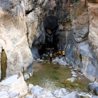
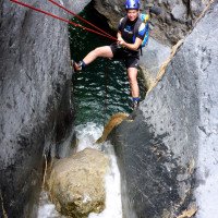
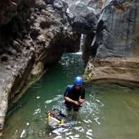
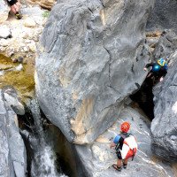
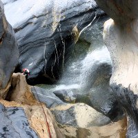
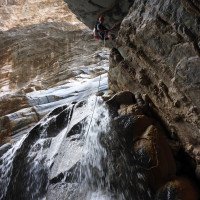
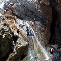
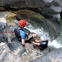
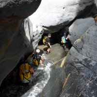
Im Wadi Bani Awf zuerst Laufstrecke,dann in einer ersten Verengung einige Gumpen, dann erneut eine kurze Laufstrecke in einer Aufweitung der Schlucht und anschließend am Ende des kiesigen Bachbettes die Abseiler. Zunächst 5m, dann 25m bis auf ein breites Sims, von da dann 15m. Nun folgt der aquatische Abstieg. Einige etwas delikate Abkletterpassagen haben wir über mittels Körpersicherung etwas angenehmer gestaltet.
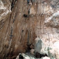
Wir passieren das von links einmündende Wadi Bimah und passieren anschließend den Sinter-"Tunnel", das optische Highlight der Tour. Dann heißt es wieder wandern und abklettern. Schließlich öffnet sich die Schlucht, aber nur vorübergehend. Am Ende steht wieder ein schmaler Durchlass, bevor man endgültig aus den engen Wänden heraustritt.
In the Wadi Bani Awf, first a running section, then some pools in a first narrowing, then another short running section in a widening of the canyon and then the rappel at the exit of the gravelly streambed. First 5m, then 25m to a wide ledge, from there 15m. Now follows the aquatic descent. We have made some somewhat delicate downclimbs a little more pleasant by using body protection.
We pass the Wadi Bimah, which flows in from the left, and then pass the sinter "tunnel", the visual highlight of the tour. Then it's back to hiking and downclimbing. Finally, the canyon opens up, but only temporarily. At the exit, there is another narrow passage before you finally emerge from the narrow walls.
Ritorno (10 min):
traduzione alternativa
➜
Lingua originale
Vom Ende der Schlucht wenige Meter zum Ende der Piste und auf dieser hinaus nach Zammah.
From the exit of the canyon a few meters to the end of the slope and on this out to Zammah.
Coordinate:
Inizio del canyon
Parcheggio in uscita
Austiegsparkplatz
Parcheggio all'entrata
Zustiegsparkplatz
Fine del canyon
Punto di passaggio
Zusammenfluß mit Seitencanyon Wadi Bimah
Info sul canyon Cwiki
Info sul canyon Descente
Info sul canyon Ropewiki
Sconosciuto
Altro info sul canyon
06.04.2025
Bina
⭐
★★★★★
📖
★★★
⚓
★★★
💧
Basso
Completato ✔
nessuna traduzione disponibile
Automatisch importiert von Descente-Canyon.com für Canyon Bani Awf
Nice Canyon
(Quelle: https://www.descente-canyon.com/canyoning/canyon-debit/23153/observations.html)
06.04.2025
Patrik Bartel
⭐
★★★★★
📖
★★★
⚓
★★★
💧
Basso
Completato ✔
traduzione alternativa
➜
Lingua originale
Altri utenti sono stati: Sarah Allemann Bina
Wunderschöner Canyon, leider nur 3 Abseiler, dafür einige Sprüngchen.
Beautiful canyon, unfortunately only 3 rappels, but some small jumps.
Altri utenti sono stati: Sarah Allemann Bina
11.03.2025
onerupee
⭐
★★★★★
📖
★★★
⚓
★★★
💧
Basso
Completato ✔
nessuna traduzione disponibile
Automatisch importiert von Descente-Canyon.com für Canyon Bani Awf
Magnifique canyon, eau douce, gorges encaissér, jeux de lumières. Un must sur le secteur !!!
(Quelle: https://www.descente-canyon.com/canyoning/canyon-debit/23153/observations.html)
03.03.2025
jerome-g
⭐
★★★★★
📖
★★★
⚓
★★★
💧
Basso
Completato ✔
nessuna traduzione disponibile
Automatisch importiert von Descente-Canyon.com für Canyon Bani Awf
Branche de Bimah uniquement.Eau propre, vasques propres.Quasiment pas de pollution de bouteilles plastiques ou autres déchets, ce que je craignais.Fait en shorty, l'eau était un peu fraiche quand même.J'ai mis la corde à un passage où l'eau me semblait insuffisante pour sauter et la désescalade compliquée (corde de rando 8 mm, 30m très largement suffisants), c'est le seul endroit où j'ai vu un point.
(Quelle: https://www.descente-canyon.com/canyoning/canyon-debit/23153/observations.html)
31.12.2024
Carog
⭐
★★★★★
📖
★★★
⚓
★★★
💧
Basso
Completato ✔
nessuna traduzione disponibile
Automatisch importiert von Descente-Canyon.com für Canyon Bani Awf
Chouette canyon avec une vue magnifique ! Équipement top sur spits. Aucun passage glissant. Possibilité d'organiser une navette et de louer du matériel auprès de l'hôtel Bait Bimah.
(Quelle: https://www.descente-canyon.com/canyoning/canyon-debit/23153/observations.html)
27.10.2024
kumharas
⭐
★★★★★
📖
★★★
⚓
★★★
💧
Normale
Completato ✔
nessuna traduzione disponibile
Automatisch importiert von Descente-Canyon.com für Canyon Bani Awf
(Quelle: https://www.descente-canyon.com/canyoning/canyon-debit/23153/observations.html)
09.03.2023
System User
⭐
★★★★★
📖
★★★
⚓
★★★
nessuna traduzione disponibile
Info: Teile der Canyonbeschreibung wurden automatisiert übernommen. Konkret die Felder Weblinks, Koordinaten, Rating, Länge des Canyon, Einfachseil Mindestens von https://www.descente-canyon.com/canyoning/canyon/23153
09.03.2023
System User
⭐
★★★★★
📖
★★★
⚓
★★★
nessuna traduzione disponibile
Daten importiert von https://canyon.carto.net/cwiki/bin/view/Canyons/BaniAwfCanyon.html
24.02.2020
GeorgB
⭐
★★★★★
📖
★★★
⚓
★★★
💧
Basso
Completato ✔
traduzione alternativa
➜
Lingua originale
Nach Übernachtung am Fussballplatz schöne Tour durch die Klamm. Einfache, gut abgesichere Tour die landschaftlich sehr eindrucksvoll und geologisch interessant ist. Kurze Höhlepassage und ein paar Sprünge möglich.
Beim Autoumstellen wurden wir von einem französischen Paar mitgenommen, sonst wäre es ein langer und staubiger Trek entlang der Straße geworden.
After spending the night at the football field beautiful tour through the gorge. Easy, well secured tour which is scenically very impressive and geologically interesting. Short cave passage and a few jumps possible.
When changing cars we were given a lift by a French couple, otherwise it would have been a long and dusty trek along the road.
Nuovo rapporto
Riportare brevemente e concisamente le informazioni più importanti dell'ultimo tour o importanti informazioni attuali sul canyon. Se necessario con link a video, foto, ecc..
*
*
*
Esc
Del
Idrologia:

1 Aufbruch
2 die erste Engstelle
3
4

5 zwischenzeitliche Aufwei...
6

7
8 der erste Abfall , 1. Ab...

9 2. Abseiler

10 3. Abseiler
11 2. Abseiler

12
13 3. Abseiler
14. Abklettern, ggf. mit S...

15.

16.
17.

18.
19.

20.

21 Engstelle
22

23

24

25 Einmündung Wadi Bimah v...

26 in's Souterrain

27 und wieder hinaus

28

29 die letzten Meter, bevo...