un po' difficile
Val Fogare (inferiore)
v4 a4 IV
3h30
1h
2h15
15min
640m
460m
180m
34m
2x40m
a piedi
Specialità:
§ Divieto
§ Divieto
Valutazione:
★★★★★
4.5 (6)
Info:
★★★
2.3 (3)
Belay:
★★★
2.4 (5)
Sintesi:
traduzione alternativa
➜
Lingua originale
Einer der schönsten und abwechslungsreichsten aquatischen Kalkschluchten in der Gegend; sauberes Wasser die Schlucht befindet sich im Nationalpark Belluneser Dolomiten, wo Canyoning offiziell nicht erlaubt ist (wird nur geduldet); viele Zecken beim Zustieg; Absicherung ausreichend; mehrere Engstellen und Sprungmöglichkeiten; kleiner Tipp: Campingplatz+Pizzeria „Sarathei“ am Lago di Santa Croce (ca. 40min. Entfernung) (www.sarathei.it)
One of the most beautiful and varied aquatic lime canyons in the area; clean water the canyon is located in the Bellunese Dolomites National Park, where canyoning is officially not allowed (is only tolerated); many ticks at the access; protection sufficient; several narrows and possible jumps; small tip: campsite+pizzeria "Sarathei" at Lago di Santa Croce (about 40min. distance) (www.sarathei.it)
Est
4.20km²
Sintesi:
traduzione alternativa
➜
Lingua originale
Einer der schönsten und abwechslungsreichsten aquatischen Kalkschluchten in der Gegend; sauberes Wasser die Schlucht befindet sich im Nationalpark Belluneser Dolomiten, wo Canyoning offiziell nicht erlaubt ist (wird nur geduldet); viele Zecken beim Zustieg; Absicherung ausreichend; mehrere Engstellen und Sprungmöglichkeiten; kleiner Tipp: Campingplatz+Pizzeria „Sarathei“ am Lago di Santa Croce (ca. 40min. Entfernung) (www.sarathei.it)
One of the most beautiful and varied aquatic lime canyons in the area; clean water the canyon is located in the Bellunese Dolomites National Park, where canyoning is officially not allowed (is only tolerated); many ticks at the access; protection sufficient; several narrows and possible jumps; small tip: campsite+pizzeria "Sarathei" at Lago di Santa Croce (about 40min. distance) (www.sarathei.it)
Accesso:
traduzione alternativa
➜
Lingua originale
Von Belluno kommend fährt man Richtung Agordo und auf der SS203 weiter in das Cordevale-Tal. Nach der Ortschaft Mas kommt der Ort Peron. Ca. 4Km nach Peron entlang des Torrente Cordevale kommt auf ein langer geraden li einen großen Picknickplatz mit Wohnmobil Stellplätze. Gegenüber ist das Haus der Comando Statzione Forestale „C. se Candaten“. Von hier aus fährt man noch 1,2km weiter bis man links bei einem verfallenen Haus einen Forstweg reinfahren kann. Hier in den Wald fahren bis man zum Torrente Cordevale kommt (hier sind auch nette Schlafplätze, die etwas abgelegen sind).
Dieser Parkplatz ist wesentlich besser als der "alte" beim Picknick-Platz, da er relativ abgeschirmt ist.
Coming from Belluno, head towards Agordo and continue on the SS203 into the Cordevale Valley. After the village of Mas comes the village of Peron. About 4Km after Peron, along the Torrente Cordevale, on a long straight left there is a large picnic area with camper pitches. Opposite is the house of the Comando Statione Forestale "C. se Candaten". From here continue for 1.2km until you reach a forest road on the left by a dilapidated house. Here you enter the forest until you reach Torrente Cordevale (here are also nice places to sleep, which are a bit secluded).
This parking lot is much better than the "old" one at the picnic area, because it is relatively shielded.
Avvicinamento (1 h):
traduzione alternativa
➜
Lingua originale
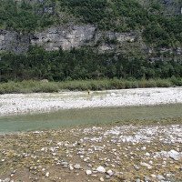
Vom Parkplatz quert man den Torrente Cordevale und geht in Richtung Süden. Es ist relativ offensichtlich wo man dann auf der anderen Uferseite in den Wald gehen muss, da davor hohe Böschungen sind an denen man nicht hoch kommt. Bei der ersten Gelegenheit wo die Böschung niedriger ist geht man in den Wald (bei unserer Begehung 14.8.2023 war dort auch ein Steinmännchen bei der Böschung). Im Wald trifft man dann auf einen offensichtlichen Weg der auch mit roten Markierungen markiert ist. Man folgt dem Weg weiter Richtung Süden bis man zum Ausgang des Val Fogare kommt (nach ca 15 min vom Parkplatz).
Man quert den Fogare und geht nach ca 20m die Böschung hinauf und trifft auf den Wanderweg der ab jetzt bergauf führt. Nach ungefähr 330m bei 480Hm folgt man nicht mehr dem Wanderweg, der gerade weiterführt sondern geht in einer Spitzkehre den Pfad weiter, der ab jetzt steil bergauf führt.
Beim Aufstieg trifft man ein Steinmanderl, eine Mauer mit Eisengeländer und eine Wegmarkierung. Nach mehreren Höhenmetern wird es plötzlich flacher. Hier hat man eine schöne Aussicht ins Tal und in die Schlucht. Für den weiteren flachen Wegverlauf oberhalb der Schlucht sollte man besser einen Helm tragen. Das zum Teil stark beschädigte Geländer sagt mehr als tausend Worte. Ab hier ca. 20min. ohne Schwierigkeit den Weg bis zum Bach/Einstieg auf ca. 640m folgen (Zecken abspülen nicht vergessen ;-) )
From the parking lot you cross the Torrente Cordevale and go south. It is relatively obvious where to go into the woods on the other side of the river, because in front of it there are high slopes that you can not climb. At the first opportunity where the embankment is lower, you go into the forest (during our walk 14.8.2023 there was also a cairn at the embankment). In the forest you will find an obvious path that is also marked with red markings. Follow the path southwards until you reach the exit of Val Fogare (after about 15 minutes from the parking lot).
Cross the Fogare and after about 20m go up the slope and meet the trail that from now on goes uphill. After about 330m at 480m, instead of following the path that goes straight on, take a hairpin bend and continue along the path that goes steeply uphill from here on.
During the ascent, you will come across a stone manderl, a wall with iron railings and a trail marker. After several meters of altitude, it suddenly becomes flatter. Here you have a beautiful view into the valley and the canyon. For the further flat path above the canyon, it is better to wear a helmet. The partly heavily damaged railing says more than a thousand words. From here about 20min. without difficulty follow the path to the stream / entry at about 640m (ticks do not forget ;-) )
Giro (2 h 15):
traduzione alternativa
➜
Lingua originale
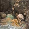
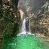
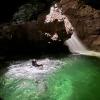
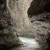
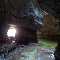
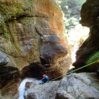
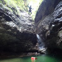
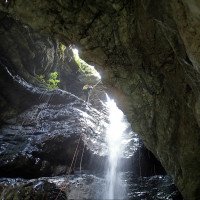
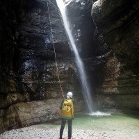
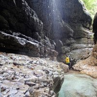
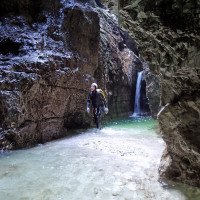
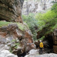
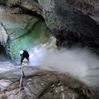
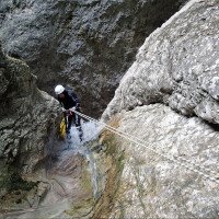
Die Fogare inferiore zählt sicherlich zu einen der schönsten und abwechslungsreichsten Schluchten im Nationalpark. Ohne große Weg strecke kommen mehrere Stufen die entweder abgeseilt oder gesprungen werden können. Einige Engstellen, eine Grotte in der Schluchtenmitte sowie das Grün schimmernde Wasser in den Becken lassen das Canyoningherz höher schlagen. Die Standplätze sind nicht mehr die Neuesten jedoch noch brauchbar und gut angebracht. Durch das nur 4,2Km² große Einzugsgebiet hat man im Normalfall keine Probleme im Wasser abzuseilen. Die Schlucht sollte aufgrund seiner Engstellen nicht unterschätzt werden! Nach der letzten eingeschnittenen Passage kommt im Bach eine kleine offene Mauer. Danach werden die letzten Meter abgeklettert. Ausstieg auf ca. 460m unterhalb des Wasserkanals.
Val Fogarè liegt im Parco Nazionale Dolomiti; die Begehung von Canyons wurde bisher geduldet,doch sollte man es nicht auf eine Begegnung mit den Rangern anlegen. Die Führung des A.I.C. verhandelt diesbezüglich schon geraume Zeit mit der Nationalparkverwaltung.
The Fogare inferiore is certainly one of the most beautiful and varied canyons in the National Park. Without a long stretch of path there are several steps that can be rappelled or jumped. Some narrow passages, a grotto in the middle of the gorge and the green shimmering water in the pools make the canyoning heart beat faster. The belay stations are not the newest anymore but still usable and well placed. Due to the only 4.2Km² large catchment area, one normally has no problems rappelling in the water. The canyon should not be underestimated because of its narrows! After the last cut passage comes in the stream a small open wall. After that the last meters are downclimbed. Exit at about 460m below the water channel.
Val Fogarè is located in the Parco Nazionale Dolomiti; canyoning has been tolerated up to now, but it should not be attempted to meet the rangers. The leadership of the A.I.C. has been negotiating for some time with the National Park Administration.
Ritorno (15 min):
traduzione alternativa
➜
Lingua originale
Beim Ausgang or. li. wieder den Weg hinauf und zum Parkplatz retour.
At the exit or. left again up the path and return to the parking lot.
Coordinate:
Inizio del canyon
46.206924°, 12.112813°
↓↑
DMS: 46° 12" 24.93', 12° 6" 46.13'
DM: 46° 12.415", 12° 6.769"
Google Maps
DMS: 46° 12" 24.93', 12° 6" 46.13'
DM: 46° 12.415", 12° 6.769"
Google Maps
Fine del canyon
Parcheggio Entrata e uscita
46.209436°, 12.128964°
↓↑
DMS: 46° 12" 33.97', 12° 7" 44.27'
DM: 46° 12.566", 12° 7.738"
Google Maps
DMS: 46° 12" 33.97', 12° 7" 44.27'
DM: 46° 12.566", 12° 7.738"
Google Maps
Letteratura:
Libro Canyoning
Pascal van Duin
Edizioni TopCanyon
2009
100 Beschreibungen
Libro Canyoning
Matteo Bortot, Roberto Sartor
ViviDolomiti
2019
978-8899106669
45 Canyon-Beschreibungen
Libro Canyoning
Simon Flower
Cicerone
2012
Northern Italy and Ticino
Info sul canyon ACA
Rapporto di viaggio (ad es. blogpost)
Info sul canyon Cwiki
Altro info sul canyon
Altro info sul canyon
23.08.2024
Barbora Kohout
⭐
★★★★★
📖
★★★
⚓
★★★
💧
Normale
Completato ✔
nessuna traduzione disponibile
Altri utenti sono stati: Miroslav
We heard that the canyon is doable. Some anchor points are old, but still functional. One traverse is "the most fun". But it's okay, everything is fine ♡
Altri utenti sono stati: Miroslav
26.07.2024
Bina
⭐
★★★★★
📖
★★★
⚓
★★★
💧
Normale
Completato ✔
traduzione alternativa
➜
Lingua originale
Altri utenti sono stati: Patrik Bartel
Mit dem oberen Teil eine wunderschöne Canyoningtour
With the upper part a wonderful canyoning tour
Altri utenti sono stati: Patrik Bartel
21.06.2024
Madie Ga
⭐
★★★★★
📖
★★★
⚓
★★★
💧
Alto
Completato ✔
nessuna traduzione disponibile
I heard the canyon is doable and all anchors are intact
14.08.2023
Horst Lambauer
⭐
★★★★★
📖
★★★
⚓
★★★
💧
Basso
Completato ✔
traduzione alternativa
➜
Lingua originale
Beschreibung des Canyons geändert. Neuer Parkplatz, der nicht so offensichtlich gegenüber vom Rangerhaus ist und wo man weniger Aufsehen erzeugt. Koordinaten des Parkplatzes sowie der Einstiege ausgebessert auf aktuelle Gegebenheiten.
Canyon ist super schön. Alle Stände ok.
Description of the canyon changed. New parking lot, which is not so obvious opposite the ranger house and where you create less fuss. Coordinates of parking lot as well as entrances touched up to current conditions.
Canyon is super nice. All stands ok.
09.03.2023
System User
⭐
★★★★★
📖
★★★
⚓
★★★
nessuna traduzione disponibile
Daten importiert von https://www.canyoning.or.at/index.php/liste-aller-canyons/401-fogare-inferiore
16.08.2022
Bubtore
⭐
★★★★★
📖
★★★
⚓
★★★
💧
Basso
Completato ✔
traduzione alternativa
➜
Lingua originale
Wenn man grad aus Grigno heraus kommt, ist es irgendwie zu erwarten dass man beim nächsten Bach leicht enttäuscht wird.
When you just come out of Grigno, it is somehow to be expected that you will be slightly disappointed at the next stream.
Nuovo rapporto
Riportare brevemente e concisamente le informazioni più importanti dell'ultimo tour o importanti informazioni attuali sul canyon. Se necessario con link a video, foto, ecc..
*
*
*
Esc
Del
Idrologia:
