un po' difficile
Lodrino (superiore) dx
Paese:
Schweiz / Switzerland
Regione: Kanton Tessin / Cantone Ticino
Sottoregione: Bezirk Riviera
Città: Lodrino
v4 a4 III
7h20
2h
5h
20min
1110m
665m
445m
50m
2x 50m
13
2500m
Auto facoltativa
Valutazione:
★★★★★
3.6 (1)
Info:
★★★
2 (1)
Belay:
★★★
0 ()
Sintesi:
traduzione alternativa
➜
Lingua originale
Attraktiver, aber relativ langer und wasserreicher Schluchtteil, im Gegensatz zu den anschließenden Abschnitten weitgehend offen.
Lodrino (superiore) sx (Riale di Mercori) ist Stand heute noch nicht beschrieben.
Attractive but relatively long and watery canyon part, largely open in contrast to the adjoining parts.
Lodrino (superiore) sx (Riale di Mercori) is not yet described as of today.
Parti
Nome
Difficoltà
Avvicinamento
Giro
Ritorno
Sud-Est
Sintesi:
traduzione alternativa
➜
Lingua originale
Attraktiver, aber relativ langer und wasserreicher Schluchtteil, im Gegensatz zu den anschließenden Abschnitten weitgehend offen.
Lodrino (superiore) sx (Riale di Mercori) ist Stand heute noch nicht beschrieben.
Attractive but relatively long and watery canyon part, largely open in contrast to the adjoining parts.
Lodrino (superiore) sx (Riale di Mercori) is not yet described as of today.
Accesso:
traduzione alternativa
➜
Lingua originale
Vom Autobahnkreuz Autobahnkreuz (Gotthard/Bernardino) im Norden von Bellinzona auf der N 2 nordwärts. Kurz nach der Ortsdurchfahrt von Cresciano li. abbiegen und zur anderen Talseite nach Lodrino (ca. 12 km ab Autobahnkreuz). In die Ortschaft (rechts) hineinfahren und nach der Brücke über den Bach die 3. Straße links. Vor dem Friedhof erstes Fahrzeug parken (die Parkplätze vor dem Supermarkt und unter den Bäumen in der Ortsmitte sollten nicht in Anspruch genommen werden). \nMit dem zweiten Auto nördlich in Richtung Iragna fahren und nach fast 2 km (ab Lodrino) unmittelbar nach den Häusern von Rodaglio bei einem Gewerbebetrieb (GPS-Koordinaten: 46°19'02.46"N / 8°58'19.70"E ) links ab auf ein kleines Strässchen, das uns hinaufbrigt zu den Häusern von Legri (eine Abzweigung nach re. - Zufahrt zum oberen Iragna - ignorieren) Es geht auf dem Sträßchen immer geradeaus, bis es auf einer freien Fläche (Hubschrauberlandeplatz)endet (bzw sich als Piste in westlicher Richtung fortsetzt). Hier das zweite Auto abstellen.
From the freeway junction (Gotthard/Bernardino) north of Bellinzona on the N 2 northwards. Shortly after passing through Cresciano, turn left and drive to the other side of the valley to Lodrino (approx. 12 km from the interchange). Enter the village (on the right) and after the bridge over the stream take the 3rd street on the left. Park the first car in front of the cemetery (do not use the parking spaces in front of the supermarket and under the trees in the center of the village). \nWith the second car go north in the direction of Iragna and after almost 2 km (from Lodrino) immediately after the houses of Rodaglio turn left at a commercial establishment (GPS coordinates: 46°19'02.46 "N / 8°58'19.70 "E ) turn left onto a small road that leads up to the houses of Legri (ignore the exit to the right - access to the upper Iragna). The road continues straight ahead until it ends in an open area (helipad) (or continues as a dirt road to the west). Park the second car here.
Avvicinamento (2 h):
traduzione alternativa
➜
Lingua originale
Vom Parkplatz (580 m ü.NN) auf anfangs betoniertem Steig aufwärts bis zu einer Wiese mit Haus. Hier zieht der Pfad links und nur mäßig ansteigend hoch über der Schlucht dahin bis zu der Stahlbrücke über den mittleren Lodrino (635 m ü.NN). Nun geht es in Serpentinen bergan, vorbei am rechts abgehenden Zustieg zum mittleren Lodrino. Bei etwa 800 m ü.NN beginnt der Weg, sich am Südhang des Lodrino langsam und gleichmäßig ansteigend in das lange Tal hinter zu ziehen. Vorbei an der ehemaligen Alpe Dureda (890 m ü.NN) erreichen wir das Seitental Val di Drosina (des Val Lodrino). Hier schwenkt der Weg nach WNW. Bei 1050 m ü.NN biegt rechts ein Pfad hinab zu einem zerstörten Eisensteg (Einstieg).
From the parking lot (580 m a.s.l.) on an initially concrete path up to a meadow with a house. Here the path turns left and climbs only moderately high above the canyon to the steel bridge over the middle Lodrino (635 m a.s.l.). Now the path goes up in serpentines, passing the access to the middle Lodrino on the right. At about 800 m a.s.l. the path begins to slowly and steadily climb up the southern slope of the Lodrino into the long valley behind. Passing the former Alpe Dureda (890 m a.s.l.) we reach the side valley Val di Drosina (of Val Lodrino). Here the path turns WNW. At 1050 m a.s.l. a path on the right descends to a destroyed iron footbridge (entry).
Giro (5 h):
traduzione alternativa
➜
Lingua originale
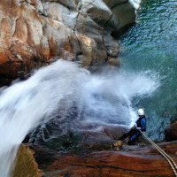
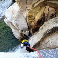
Nach kleineren Abseilern in einem Waldgraben kommen wir zur C 50, dem einzig höheren Abseiler. Danach offenes Flussbett mit einigen engeren Passagen. Der Lodrino sup. sollte nur begangen werden, wenn der Wasserstand auch eine Begehung des unteren (und mittleren) Abschnittes zulassen würde, da auch im L. sup. Engstellen sind, die bei erhöhtem Wasserdurchsatz kritisch und noch nicht für eine entsprechende Begehung eingesichert sind (2008).
After smaller rappels in a forest canyon we come to C 50, the only higher rappel. After that open riverbed with some narrower passages. The Lodrino sup. should only be climbed if the water level would also allow an ascent of the lower (and middle) part, since also in the L. sup. are narrow passages that are critical at increased water flow and are not yet secured for an appropriate ascent (2008).
Ritorno (20 min):
traduzione alternativa
➜
Lingua originale
Nach einer längeren Gehstrecke dann beim Zustieg zum Lodrino med. (7-m-Sprung vor der Rampe mit dem hohen Abseiler)rechts hinaus und auf dem Anstiegsweg zurück. Selbsverständlich kann man hier den mittleren Abschnitt des Lodrino anhängen und bis zur Eisenbahnbrücke am Beginn des unteren Abschnitts weitergehen.
After a long walking passages, at the access to the Lodrino med. (7 m jump before the ramp with the high rappel), exit to the right and return on the ascent path. Of course, it is possible to add the middle part of the Lodrino and continue until the railroad bridge at the beginning of the lower part.
Coordinate:
Inizio del canyon
46.28112°, 8.94727°
↓↑
DMS: 46° 16" 52.03', 8° 56" 50.17'
DM: 46° 16.867", 8° 56.836"
Google Maps
Svizzera Topografica
DMS: 46° 16" 52.03', 8° 56" 50.17'
DM: 46° 16.867", 8° 56.836"
Google Maps
Svizzera Topografica
Parcheggio Entrata e uscita
46.2978°, 8.9733°
↓↑
DMS: 46° 17" 52.08', 8° 58" 23.88'
DM: 46° 17.868", 8° 58.398"
Google Maps
Svizzera Topografica
DMS: 46° 17" 52.08', 8° 58" 23.88'
DM: 46° 17.868", 8° 58.398"
Google Maps
Svizzera Topografica
Parkplatz bei Hubschrauberlandeplatz, an der Straße nicht auf dem Schotter parken.
Fine del canyon
46.2939°, 8.9621°
↓↑
DMS: 46° 17" 38.04', 8° 57" 43.56'
DM: 46° 17.634", 8° 57.726"
Google Maps
Svizzera Topografica
DMS: 46° 17" 38.04', 8° 57" 43.56'
DM: 46° 17.634", 8° 57.726"
Google Maps
Svizzera Topografica
Sito del contatore del livello dell'acqua
46.30081°, 8.97719°
↓↑
DMS: 46° 18" 2.92', 8° 58" 37.88'
DM: 46° 18.049", 8° 58.631"
Google Maps
Svizzera Topografica
DMS: 46° 18" 2.92', 8° 58" 37.88'
DM: 46° 18.049", 8° 58.631"
Google Maps
Svizzera Topografica
Partenza alternativa del canyon
46.27534°, 8.94133°
↓↑
DMS: 46° 16" 31.22', 8° 56" 28.79'
DM: 46° 16.52", 8° 56.48"
Google Maps
Svizzera Topografica
DMS: 46° 16" 31.22', 8° 56" 28.79'
DM: 46° 16.52", 8° 56.48"
Google Maps
Svizzera Topografica
Val di Drosina SUP
Letteratura:
Mappa
1:25000
Libro Canyoning
Stéphane Coté / Caracal et les Sancho Panza
2007
124 Canyon-Beschreibungen
Libro Canyoning
Matthias Holzinger & Thomas Guigon
Pixartprinting.ch
2020
Info sul canyon Cwiki
Info sul canyon Descente
Info sul canyon Ropewiki
Info sul canyon Swisscanyon
21.09.2024
CorsacEspritCanyoncharly67
⭐
★★★★★
📖
★★★
⚓
★★★
💧
Normale
Completato ✔
nessuna traduzione disponibile
Automatisch importiert von Descente-Canyon.com für Canyon Lodrino (supérieur)
Lodrino intégral. RAS.
(Quelle: https://www.descente-canyon.com/canyoning/canyon-debit/21001/observations.html)
21.09.2024
Corsac
⭐
★★★★★
📖
★★★
⚓
★★★
💧
Normale
Completato ✔
nessuna traduzione disponibile
Automatisch importiert von Descente-Canyon.com für Canyon Lodrino (supérieur)
Fait l'intégral. Après le point 636m, le chemin n'est pas très marqué mais quand-même visible. Quelques troncs à contourner.Pas mal de section de marche sur la partie supérieure. Jolies cascades et jolis saut (important de les vérifier).Partie intermédiaire, plus encastrée et plus ludique.Et partie inférieure, magnifique, belle ambiance.
(Quelle: https://www.descente-canyon.com/canyoning/canyon-debit/21001/observations.html)
18.09.2024
jujul..
⭐
★★★★★
📖
★★★
⚓
★★★
💧
Normale
Completato ✔
nessuna traduzione disponibile
Automatisch importiert von Descente-Canyon.com für Canyon Lodrino (supérieur)
Majeur! Avons fait la descente intégrale. Bcp de monos points, certains en état moyens. A faire sans hésitation
(Quelle: https://www.descente-canyon.com/canyoning/canyon-debit/21001/observations.html)
18.09.2024
RoroCanyonAristude
⭐
★★★★★
📖
★★★
⚓
★★★
💧
Normale
Completato ✔
nessuna traduzione disponibile
Automatisch importiert von Descente-Canyon.com für Canyon Lodrino (supérieur)
Nous avons perdu un sac noir et rouge dans la partie inférieure du Lodrino aujourd'hui, avec une corde de 50m jaune à l'intérieur. Si vous le retrouvez, je suis joignable au +33670410545, message ou WhatsApp.Merci à vous !!!We lost a black and red bag in the lower part of Lodrino today, with a 50m yellow rope inside. If you find it, I can be reached at +33670410545, message or WhatsApp. Thank you !!!
(Quelle: https://www.descente-canyon.com/canyoning/canyon-debit/21001/observations.html)
21.08.2024
Johnny
⭐
★★★★★
📖
★★★
⚓
★★★
💧
Normale
Completato ✔
nessuna traduzione disponibile
Automatisch importiert von Descente-Canyon.com für Canyon Lodrino (supérieur)
Deux plaquette manque sur deux cascade vers la fin. Prévoir 2 plaquettes avec 2 écrous. Canyon magnifique
(Quelle: https://www.descente-canyon.com/canyoning/canyon-debit/21001/observations.html)
13.08.2024
maxime_b
⭐
★★★★★
📖
★★★
⚓
★★★
💧
Normale
Completato ✔
nessuna traduzione disponibile
Automatisch importiert von Descente-Canyon.com für Canyon Lodrino (supérieur)
(Quelle: https://www.descente-canyon.com/canyoning/canyon-debit/21001/observations.html)
02.04.2023
Daniel Sturm
⭐
★★★★★
📖
★★★
⚓
★★★
Completato ✕
traduzione alternativa
➜
Lingua originale
Beschreibung ergänzt/geupdated.
Description added/updated.
09.03.2023
System User
⭐
★★★★★
📖
★★★
⚓
★★★
nessuna traduzione disponibile
Daten importiert von https://canyon.carto.net/cwiki/bin/view/Canyons/LodrinosuperioreCanyon.html
Nuovo rapporto
Riportare brevemente e concisamente le informazioni più importanti dell'ultimo tour o importanti informazioni attuali sul canyon. Se necessario con link a video, foto, ecc..
*
*
*
Esc
Del


