non così difficile
Schlaniggraben
Paese:
Österreich / Austria
Regione: Land Salzburg
Sottoregione: Bezirk St. Johann im Pongau
Città: Untertauern
v3 a2 III
3h50
1h30
2h
20min
1544m
1070m
474m
30m
2x50m
8
1100m
Auto necessaria
Valutazione:
★★★★★
0 ()
Info:
★★★
0 ()
Belay:
★★★
0 ()
Sintesi:
traduzione alternativa
➜
Lingua originale
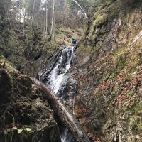
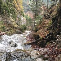
pure rappel canyon in clean cold water, very slippery, in the upper part first river walk (first third; if necessary look for alternative entry!) then beautiful canyon with well equipped stands; mostly two bolts (no chain anchors),
luglio - novembre
Est
Calcare