difficile
Müselbach
v5 a1 II
1h50
30min
1h
20min
860m
720m
140m
55m
2x 60m
3
200m
Auto necessaria
Valutazione:
★★★★★
2.6 (2)
Info:
★★★
0 ()
Belay:
★★★
0 ()
Sintesi:
traduzione alternativa
➜
Lingua originale
Wer hohe Abseilstellen liebt, der ist dort richtig. fast 60m geht's hier in einem Stück hinunter in des Jungle's End. Ansonsten eher kurze Schlucht die in Kombination mit der Kobelache (KanguruJumpingCanyon) Sinn macht.
Who loves high rappels, this is the right place. 60m goes here in one piece in the Jungle's End. Otherwise rather short canyon that only makes sense in combination with the Kobelach (KanguruJumpingCanyon).
Nord
Sintesi:
traduzione alternativa
➜
Lingua originale
Wer hohe Abseilstellen liebt, der ist dort richtig. fast 60m geht's hier in einem Stück hinunter in des Jungle's End. Ansonsten eher kurze Schlucht die in Kombination mit der Kobelache (KanguruJumpingCanyon) Sinn macht.
Who loves high rappels, this is the right place. 60m goes here in one piece in the Jungle's End. Otherwise rather short canyon that only makes sense in combination with the Kobelach (KanguruJumpingCanyon).
Accesso:
traduzione alternativa
➜
Lingua originale
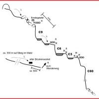
Autobahnabfahrt Dornbirn Süd und dann weiter Richtung Gütle. Am besten man lässt beim Gasthof in Gütle ein Rad (bzw. zweites Auto) stehen und fährt mit dem Auto weiter Richtung Ebnit. Man überquert die Rappenlochschlucht über eine Brücke und nach weiteren 650m zweigt links ansteigend eine Strasse ab. Dieser folgt man bis auf einen Sattel wo man parken kann.
Freeway exit Dornbirn Süd and then continue in the direction of Gütle. It is best to leave a bike (or second car) at the inn in Gütle and continue by car in the direction of Ebnit. Cross the Rappenlochschlucht gorge over a bridge and after another 650m a road branches off to the left uphill. Follow this road until you reach a saddle where you can park.
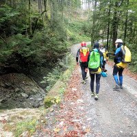
Avvicinamento (30 min):
traduzione alternativa
➜
Lingua originale
Man folgt der Strasse noch etwa 80m bis links eine Forststrasse abzweigt der man nun ziemlich genau 2km bis zu einer Brücke folgt.
Follow the road for about 80m until a forest road branches off to the left, which you follow for about 2km until you reach a bridge.
Giro (1 h):
traduzione alternativa
➜
Lingua originale
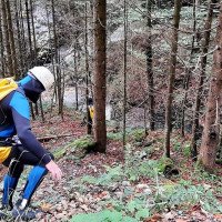
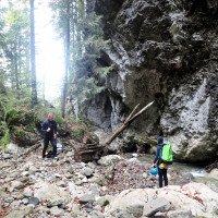
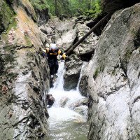
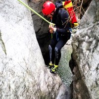
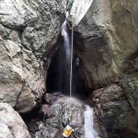
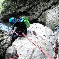
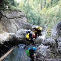
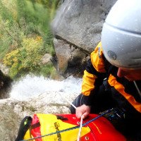
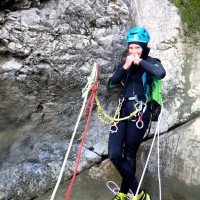
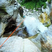
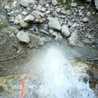
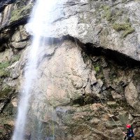
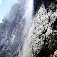
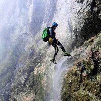
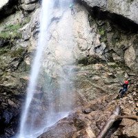
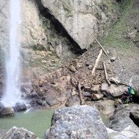
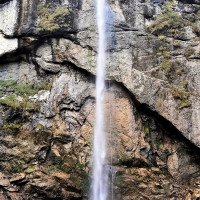
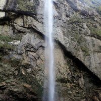
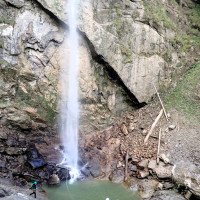
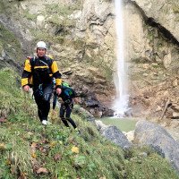
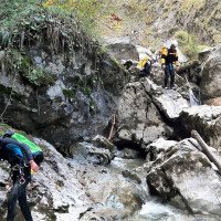
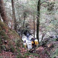
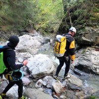
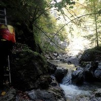
Zuerst steigt man vor der Brücke, orographisch links vom Bach, auf einem kleinen Pfad ab. Über ein paar Felsen abkletternd erreicht man den ersten Abseiler. Es folgt ein weiterer kleiner Abseiler, dann der hohe Wasserfall. Dieser schöne, über ca. 40m frei hängende Abseiler wird in einem bezwungen. Man folgt nun zuerst dem Bach und, kann dann aber auch links im Wald einen schmalen Pfad benutzen. Nach ca. 300m kommt man zu einem alten Brückenpfeiler bei dem man wieder in den Bach hinuntersteigt. Nach weiteren 50 m sind auf der rechten Seite eine Leiter (2021) und Steigspuren erkennbar, die zu einem Pfad führen.
First you descend before the bridge, orographically left, on a small path. Climbing over a few rocks, you reach the entry panel. It immediately goes once into a half cave and then over some smaller rappel to the 60m waterfall. This beautiful, over about 40m free-hanging rappel is conquered in one. You now first follow the stream and, but then you can also use a narrow path on the left in the forest. After about 300m you come to an old bridge pier where you descend again into the stream. After another 50 m, on the right side, there are climbing tracks that lead to a path.
Ritorno (20 min):
traduzione alternativa
➜
Lingua originale
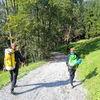
Man folgt dem Pfad nun 250m bis zu einer Wegkreuzung. Steigt man links ab kommt man zur Kobelache (KanguruJumpingCanyon). Will man die Tour schon beenden folgt man dem anderen Weg, der später in eine Strasse übergeht zurück nach Gütle. Der Konditionsstärkste darf nun mit dem Rad noch die steilste öffentliche Strasse Vorarlbergs hochradeln und das Auto vom Parkplatz abholen. (je nach Motivation um die 30min)
Follow the path for 250m until you reach a crossroads. If you descend to the left, you will reach the Kobelach (KanguruJumpingCanyon). If you want to finish the tour, follow the other path, which later turns into a road, back to Gütle. The most fit may now cycle up the steepest public road in Vorarlberg and pick up the car from the parking lot. (depending on motivation around 30min)
Coordinate:
Inizio del canyon
47.3808°, 9.79858°
↓↑
DMS: 47° 22" 50.88', 9° 47" 54.89'
DM: 47° 22.848", 9° 47.915"
Google Maps
Austria Topografica
DMS: 47° 22" 50.88', 9° 47" 54.89'
DM: 47° 22.848", 9° 47.915"
Google Maps
Austria Topografica
Fine del canyon
47.382°, 9.7939°
↓↑
DMS: 47° 22" 55.2', 9° 47" 38.04'
DM: 47° 22.92", 9° 47.634"
Google Maps
Austria Topografica
DMS: 47° 22" 55.2', 9° 47" 38.04'
DM: 47° 22.92", 9° 47.634"
Google Maps
Austria Topografica
Parcheggio in uscita
47.3914°, 9.77487°
↓↑
DMS: 47° 23" 29.04', 9° 46" 29.53'
DM: 47° 23.484", 9° 46.492"
Google Maps
Austria Topografica
DMS: 47° 23" 29.04', 9° 46" 29.53'
DM: 47° 23.484", 9° 46.492"
Google Maps
Austria Topografica
Parcheggio all'entrata
47.38071°, 9.79847°
↓↑
DMS: 47° 22" 50.56', 9° 47" 54.49'
DM: 47° 22.843", 9° 47.908"
Google Maps
Austria Topografica
DMS: 47° 22" 50.56', 9° 47" 54.49'
DM: 47° 22.843", 9° 47.908"
Google Maps
Austria Topografica
Falls hier nicht parkiert werden kann beim Parkplatz Kobelache parkieren.
Letteratura:
Mappa
Mappa
1:50000
Libro Canyoning
Stéphane Coté / Caracal et les Sancho Panza
2008
Libro Canyoning
Stéphane Coté / Caracal et les Sancho Panza
2007
124 Canyon-Beschreibungen
Info sul canyon Cwiki
Info sul canyon Descente
Info sul canyon Ropewiki
Gallería
Info sul canyon Schlucht.ch
Altro info sul canyon
09.03.2023
System User
⭐
★★★★★
📖
★★★
⚓
★★★
nessuna traduzione disponibile
Info: Teile der Canyonbeschreibung wurden automatisiert übernommen. Konkret die Felder Weblinks, Koordinaten, Rating, Länge des Canyon, Einfachseil Mindestens von https://www.descente-canyon.com/canyoning/canyon/21765
09.03.2023
System User
⭐
★★★★★
📖
★★★
⚓
★★★
nessuna traduzione disponibile
Daten importiert von https://canyon.carto.net/cwiki/bin/view/Canyons/JunglesEndCanyon.html
Nuovo rapporto
Riportare brevemente e concisamente le informazioni più importanti dell'ultimo tour o importanti informazioni attuali sul canyon. Se necessario con link a video, foto, ecc..
*
*
*
Esc
Del
Idrologia:
nessuna traduzione disponibile
https://vowis.vorarlberg.at/stationsInfo/tbl_Abflussstationen.aspx
Topo aus dem Jahr 2000 erste...
1 an der Brücke ..
2 rechts hinunter ,,,
3 ... durch den Wald
4 zum Bach

5
6
7 erster Abseiler
8 dito
9 zweiter Abseiler
10 Stand am hohen Abseiler
11 Arbeit am Stand
11 mit Zuschauerin
12 "Anlauf" zum Hohen
13 Tiefblick an der Kante
12 der Hohe
13 dito
14 dito
15 dito
16
17
18
19
20
21
22
23 wir queren den Bach
24
25 auf dem Weg zum Gütle....