v3 a3 II
2h55
30min
2h15
10min
910m
720m
190m
20m
2x40m (2x30m)
10
800m
a piedi
Valutazione:
★★★★★
2.5 (8)
Info:
★★★
2.2 (5)
Belay:
★★★
2 (6)
Sintesi:
traduzione alternativa
➜
Lingua originale
Diskontinuierliche offene Kalkschlucht; Wurde im Herbst 2022 saniert; somit meist Kettenstände die einen durchs Wasser führen aber auch noch teilweise alte Schlingen um Bäume (ausserhalb des Wasserstrahls)
Mehrere Abkletterpassagen; brüchigen Gestein im unteren Teil; bis am Schluss mehrere Ausstiegsmöglichkeiten; letzte Abseilstellen können bei hohen Wasserstand problematisch werden.
Discontinuous open lime canyon; mostly only tree loops or homemade lugs with majoglied (replace if necessary);some slippery spots; several downclimb passages; brittle rock in the lower part; until the end several exit options; last rappelling points can be problematic when the water level is high; usually little water; stand reserve material with you; rusty wire rope leads through the 1st part of the canyon.
* Tip: Pizzeria Garni Pontafel in Pontebba (Via Mazzini 61, I-33016 Pontebba).
Accesso:
traduzione alternativa
➜
Lingua originale
Von Tarvisio fährt man auf der Bundesstraße oder über die Autobahn zur Ortschaft Pontebba. In Pontebba fährt man durch die Ortschaft weiter Richtung Studena Bassa (Achtung NICHT Studena alta!) bzw. Passo del Cason di Lanza. Die Straße führt entlang der Torrente Pontebbana. Erste eher schlechte Parkmöglichkeit ist rechts am Straßenrand vor der Brücke wo die erste Zustiegsmöglichkeit beginnt. Praktischer erscheint es ca 1 km weiter zu fahren und den großen Wandererparkplatz (selber wie bei Pricotic) zu verwenden. Von dort zweigt auch der alternative Zustieg ab (etwas scheller)
about 20min.
From Tarvisio take the main road or the highway to Pontebba. In Pontebba, drive through the village in the direction of Studena Bassa (Attention NOT Studena alta!) or Passo del Cason di Lanza. The road goes along the Torrente Pontebbana. After the inn on the right, there is a conspicuous blue house with parking on the left. Park here. To check the water level at the last rappel point, continue a short distance to the ruins (behind the ruins, the Pricot joins the Torrente Pontebbana).
Avvicinamento (30 min):
traduzione alternativa
➜
Lingua originale
Vom Parkplatz unten folgt man der Forststraße über die Brücke und weiter steil Bergauf. Nach einigen HM trifft man wieder auf eine Holzbrücke (Mittelteil) die über den Rio Pricot führt. Ab hier nochmals steil bergauf bis man auf ein alleinstehendes Haus trifft. Hier re ohne Schwierigkeit auf ca. 910m in den Bach einsteigen.
Parkt man am Wandererparkplatz "oben" folgen man den Wanderweg um nach ca 15min auf die Forststr. (anderer Zustieg) zu treffen . Ab hier ist man in Kürze beim Einstieg
approx. 30min.
From the parking lot, follow the road briefly until you reach the no-driving sign where a forest road branches off to the right. Here you follow the forest road over the bridge and continue steeply uphill. After a few meters you will come to a wooden bridge (middle section) that leads over the Rio Pricot. From here again steeply uphill until you reach a detached house. Here right without difficulty at about 910m enter the stream.
Giro (2 h 15):
traduzione alternativa
➜
Lingua originale
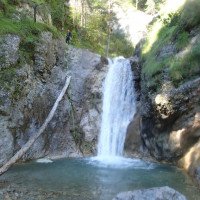
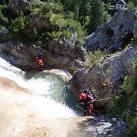
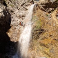
Die Schlucht beginnt mit rutschigen Abkletterstellen und 4 kleinere Stufen zwischen 10-15m . Der vierte Abseiler kann meist abgeklettert und gerutscht werden (Felsen in Gumpenmitte!!!). Für die nächste 20m Stufe findet man sowohl links als auch rechts Abseilmöglichkeiten. Es folgt ein 15m Abseiler, eine kurze Gehstrecke und ein 3m Sprung vor der Holzbrücke (Zustiegsweg). Bei der Brücke kann gemütlich Aus- bzw. eingestiegen werden (Schluchtenmitte). Der zweite Teil der Tour beginnt mit einer längeren Abkletterpassage über rutschige schräge Felsplatten und Blockkletterei. Nach dem Felshaufen kommt nochmals eine kurze schräge Felsplatte. Hier re abklettern oder zur Sicherheit über einen beliebigen Baum eine Seilsicherung aufbauen. Es folgt eine Abkletterstelle über Felsen bevor es mit den 4 schönen Stufen weiter geht. Die erste der Stufen wird 15m li abgeseilt. Danach kommt eine 5m Abseiler re. Zur letzten 15m Stufe gelangt man am besten mit einen Abziehbaren Seilgeländer. Dieses wird vom Standplatz oberhalb einer kleinen Stufe eingerichtet. Die Tour endet nach dem 15m Wasserfall auf ca. 720m.
about 2-2,5h
The canyon starts with slippery downclimbs and 4 smaller steps between 10-15m (tree loop). The fourth rappel can be mostly downclimbed and slid (rock in the middle of the gorge!!!). The belaystation for the next 20m steps is on the right side (tree loop preferred!) A 15m rappel, a short walking passages and a 3m jump before the wooden bridge (access path) follows. At the bridge you can comfortably exit or enter (center of the gorge). The second part of the tour begins with a longer downclimb over slippery sloping rock slabs and block climbing. After the rock pile there is another short sloping rock slab. Here downclimb to the right or, for safety, set up a rope belay over any tree. A downclimb over rocks follows before continuing with the 4 beautiful steps. The first step is rappelled 15m left. After that there is a 5 m rappel on the right. The best way to get to the last 15 m step is to use a removable rope traverse. This is set up from the belaystation above a small step. The tour ends after the 15m waterfall at about 720m.
Ritorno (10 min):
traduzione alternativa
➜
Lingua originale
Den Bach bis zur Einmündung (Torrente Pontebbana) folgen und je nach Parkplatz nach links oder rechts abzweigen. Wählt man den Wandererparkplatz geht man den Torrente Pontebbana ca 50m aufwärts bis ein Weg links zu Straße führt. Dieser für ca 5-10min folgen.
about 10min.
Follow the stream until the junction (Torrente Pontebbana) and cross it immediately. Continue across the meadow to the road and left back to the parking lot.
Coordinate:
Inizio del canyon
(cwiki_1)
Parcheggio Entrata e uscita
46.526424°, 13.251022°
↓↑
DMS: 46° 31" 35.13', 13° 15" 3.68'
DM: 46° 31.585", 13° 15.061"
Google Maps
DMS: 46° 31" 35.13', 13° 15" 3.68'
DM: 46° 31.585", 13° 15.061"
Google Maps
Großer Parkplatz für Pricot und Pricotic
Fine del canyon
(cwiki_1)
Parcheggio Entrata e uscita
46.523455°, 13.262563°
↓↑
DMS: 46° 31" 24.44', 13° 15" 45.23'
DM: 46° 31.407", 13° 15.754"
Google Maps
DMS: 46° 31" 24.44', 13° 15" 45.23'
DM: 46° 31.407", 13° 15.754"
Google Maps
Wenig Platz am rechten Straßenrand
Info sul canyon ACA
Info sul canyon Cwiki
Info sul canyon Descente
22.10.2024
Max H.
⭐
★★★★★
📖
★★★
⚓
★★★
💧
Alto
Completato ✔
traduzione alternativa
➜
Lingua originale
Altri utenti sono stati: Sebastian Hehenwarter Steffi Oe.
Wasserstandbild von der Straße unten zu dem Bach oben etwas "verzerrt", sprich wir hatten etwas mehr Wasser im Bach als erwartet. Bach war teilweise rutschig, verträgt aber auch gut Wasser. Teilweise Standplätze außerhalb der Wasserführung am Baum verwendet bzw. eingerichtet und an manchen Stellen Seilbahnsysteme angewendet. Tour bei Brücke aufgrund Wasserstand abgebrochen.
The water level from the road below to the stream above was somewhat "distorted", i.e. we had a little more water in the stream than expected. The stream was slippery in places, but also tolerates water well. Some of the stands were used or set up outside the water flow on the tree and ropeway systems were used in some places. Tour aborted at bridge due to water level.
Altri utenti sono stati: Sebastian Hehenwarter Steffi Oe.
09.08.2024
Marosffy Dániel
⭐
★★★★★
📖
★★★
⚓
★★★
💧
Basso
Completato ✔
nessuna traduzione disponibile
The first third (till the bridge) is nice and well equipped. The middle part is rather to forget, nothing to do but walk. The final part is interesting, but the rigging and the rock here require nerves. All together it makes a quite amusing short tour.
03.08.2024
Horst Lambauer
⭐
★★★★★
📖
★★★
⚓
★★★
💧
Normale
Completato ✔
traduzione alternativa
➜
Lingua originale
Alle Stände ok, nette Anfängerschlucht
All stands ok, nice beginner gorge
29.04.2024
Péter Bonczi
⭐
★★★★★
📖
★★★
⚓
★★★
💧
Alto
Completato ?
traduzione alternativa
➜
Lingua originale
Nagyon sok hideg víz. A hídnál befejeztük.
A lot of cold water. We left at the bridge.
06.10.2023
Wolfgang
⭐
★★★★★
📖
★★★
⚓
★★★
💧
Normale
Completato ✔
traduzione alternativa
➜
Lingua originale
Nette Kurz NM Schlucht, Stände alle ok. Der große Wandererparkplatz bietet sich ideal an ; sowohl gute Zustieg als auch gemütlicher Retourweg
Nice short NM gorge, stands all ok. The large hikers' parking lot is ideal ; both good access and cozy return route.
07.05.2023
Rok
⭐
★★★★★
📖
★★★
⚓
★★★
💧
Alto
Completato ✔
traduzione alternativa
➜
Lingua originale
Oberer Teil teilweise mit Kettenständen saniert. Auch sonst gute Absicherung. Im unteren Teil sind einige selbstgebaute Stände. Gehen aber noch. Könnte man irgendwann mal tauschen. Wir hatten gut Wasser.
Upper part partially renovated with chain stalls. Also otherwise good protection. In the lower part are some self-built stands. Go but still. Could be exchanged at some point. We had good water.
09.03.2023
System User
⭐
★★★★★
📖
★★★
⚓
★★★
nessuna traduzione disponibile
Info: Teile der Canyonbeschreibung wurden automatisiert übernommen. Konkret die Felder Weblinks, Koordinaten, Rating, Ort, Länge des Canyon, Einfachseil Mindestens von https://canyon.carto.net/cwiki/bin/view/Canyons/RioPricotCanyon.html und https://www.descente-canyon.com/canyoning/canyon/23816
09.03.2023
System User
⭐
★★★★★
📖
★★★
⚓
★★★
nessuna traduzione disponibile
Daten importiert von https://www.canyoning.or.at/index.php/liste-aller-canyons/396-rio-pricot
Nuovo rapporto
Riportare brevemente e concisamente le informazioni più importanti dell'ultimo tour o importanti informazioni attuali sul canyon. Se necessario con link a video, foto, ecc..
*
*
*
Esc
Del
Idrologia:
