facile
Covatanne
Paese:
Schweiz / Switzerland
Regione: Kanton Waadt / Canton de Vaud
Sottoregione: Ancien district de Grandson
Città: Vuiteboeuf
v2 a2 II
2h45
40min
2h
5min
810m
600m
210m
15m
2x 20m
9
1500m
a piedi
Valutazione:
★★★★★
3.1 (2)
Info:
★★★
2 (1)
Belay:
★★★
3 (1)
Sintesi:
traduzione alternativa
➜
Lingua originale
Waldgraben, in zwei auseinanderliegende Abschnitte geteilt, mit kleineren Abseilern und Funpotential.
Forest canyon, divided into two parts apart, with smaller rappels and fun potential.
maggio - ottobre
Sud-Est
Calcare
14.00km²
Sintesi:
traduzione alternativa
➜
Lingua originale
Waldgraben, in zwei auseinanderliegende Abschnitte geteilt, mit kleineren Abseilern und Funpotential.
Forest canyon, divided into two parts apart, with smaller rappels and fun potential.
Accesso:
traduzione alternativa
➜
Lingua originale
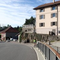
Wir verlassen die A5 (Yverdon - Neuchâtel) über die Ausfahrt Yverdon-Ouvest ud nehmen die Straße nach Sainte Croic in Richtung NW. Nach etwa 6 km erreichen wir den Ort Vuiteboeuf und stellen unser Auto am nördlichen Ortsausgang in der Nähe der Brücke über den Arnon ab (siehe Anfahrt in Fotogalerie).
We leave the A5 (Yverdon - Neuchâtel) via the exit Yverdon-Ouvest ud take the road to Sainte Croic in direction NW. After about 6 km we reach the village of Vuiteboeuf and park our car at the northern exit of the village near the bridge over the Arnon (see approach in photo gallery).
Avvicinamento (40 min):
traduzione alternativa
➜
Lingua originale
Vor der Straßenbrücke über den Arnon gehen wir links auf den Wanderweg Richtung Sainte Croix. Nach gut einer halben Stunde kreuzt dieser den Fluss. Danach suchen wir eine Zustiegsmöglichkeit in den Fluss.
Before the road bridge over the Arnon, we turn left onto the hiking trail towards Sainte Croix. After a good half hour, this crosses the river. After that we look for an entry point into the river.
Giro (2 h):
traduzione alternativa
➜
Lingua originale
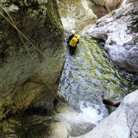
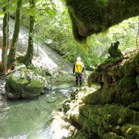
Der erste Abschnitt bietet einige kleinere Abseiler. Am Ende der kurzen Einschluchtung nimmt man am besten wieder den Zustiegsweg zurück und steigt dann direkt vor Beginn des zweiten und interessanteren Schluchtabschnitts ein. Hier einige Sprung- und Rutschmöglichkeiten.
The first part offers some smaller rappels. At the end of the short gorge, it is best to take the access path back and then climb right before the beginning of the second and more interesting section of the gorge. Here are some jumps and slides.
Ritorno (5 min):
traduzione alternativa
➜
Lingua originale
Wo die Schlucht endet, rechts hinauf auf den Weg und hinaus zum Auto.
Where the canyon ends, right up the trail and out to the car.
Coordinate:
Inizio del canyon
46.8156°, 6.5306°
↓↑
DMS: 46° 48" 56.16', 6° 31" 50.16'
DM: 46° 48.936", 6° 31.836"
Google Maps
Svizzera Topografica
DMS: 46° 48" 56.16', 6° 31" 50.16'
DM: 46° 48.936", 6° 31.836"
Google Maps
Svizzera Topografica
Fine del canyon
46.8088°, 6.5449°
↓↑
DMS: 46° 48" 31.68', 6° 32" 41.64'
DM: 46° 48.528", 6° 32.694"
Google Maps
Svizzera Topografica
DMS: 46° 48" 31.68', 6° 32" 41.64'
DM: 46° 48.528", 6° 32.694"
Google Maps
Svizzera Topografica
Parcheggio Entrata e uscita
46.80758°, 6.54629°
↓↑
DMS: 46° 48" 27.29', 6° 32" 46.64'
DM: 46° 48.455", 6° 32.777"
Google Maps
Svizzera Topografica
DMS: 46° 48" 27.29', 6° 32" 46.64'
DM: 46° 48.455", 6° 32.777"
Google Maps
Svizzera Topografica
Letteratura:
Mappa
1:25000
Libro Canyoning
Emmanuel Belut / Laurence Boyé / Thomas Guigon
Association Openbach
2015
9782746679450
Info sul canyon Cwiki
Info sul canyon Descente
Info sul canyon Ropewiki
20.04.2025
Wolf-garou
⭐
★★★★★
📖
★★★
⚓
★★★
💧
Normale
Completato ✔
nessuna traduzione disponibile
Automatisch importiert von Descente-Canyon.com für Canyon Covatanne
(Quelle: https://www.descente-canyon.com/canyoning/canyon-debit/22230/observations.html)
07.02.2025
JoKar
⭐
★★★★★
📖
★★★
⚓
★★★
💧
Normale
Completato ✔
nessuna traduzione disponibile
Automatisch importiert von Descente-Canyon.com für Canyon Covatanne
RAS
(Quelle: https://www.descente-canyon.com/canyoning/canyon-debit/22230/observations.html)
18.02.2024
Gautama108
⭐
★★★★★
📖
★★★
⚓
★★★
💧
Normale
Completato ✔
nessuna traduzione disponibile
Automatisch importiert von Descente-Canyon.com für Canyon Covatanne
RAS. Ca occupe une petite après-midi.
(Quelle: https://www.descente-canyon.com/canyoning/canyon-debit/22230/observations.html)
29.10.2023
Jeroen k
⭐
★★★★★
📖
★★★
⚓
★★★
💧
Normale
Completato ✔
nessuna traduzione disponibile
Automatisch importiert von Descente-Canyon.com für Canyon Covatanne
The cave was nice and with water. The canyon was the extra and not very special, also the mix of sometimes obsolete bolts, cables etc do not add to the experience.
(Quelle: https://www.descente-canyon.com/canyoning/canyon-debit/22230/observations.html)
09.03.2023
System User
⭐
★★★★★
📖
★★★
⚓
★★★
nessuna traduzione disponibile
Info: Teile der Canyonbeschreibung wurden automatisiert übernommen. Konkret die Felder Weblinks, Koordinaten, Rating, Länge des Canyon, Einfachseil Mindestens von https://www.descente-canyon.com/canyoning/canyon/22230
09.03.2023
System User
⭐
★★★★★
📖
★★★
⚓
★★★
nessuna traduzione disponibile
Daten importiert von https://canyon.carto.net/cwiki/bin/view/Canyons/CovatanneCanyon.html
20.09.2020
Bubtore
⭐
★★★★★
📖
★★★
⚓
★★★
💧
Normale
Completato ✔
traduzione alternativa
➜
Lingua originale
Kleine Tour, für das Jura gar nicht mal so schlecht.
Small tour, not bad at all for the Jura.
Nuovo rapporto
Riportare brevemente e concisamente le informazioni più importanti dell'ultimo tour o importanti informazioni attuali sul canyon. Se necessario con link a video, foto, ecc..
*
*
*
Esc
Del
Idrologia:


