difficile
Takamaka 1
Paese:
France
Regione: Réunion (La) / Reunion
Sottoregione: arrondissement de Saint-Benoît
Città: Saint-Benoît
v5 a5 IV
7h3
3min
5h
2h
72m
80
a piedi
Valutazione:
★★★★★
4.5 (2)
Info:
★★★
2.5 (2)
Belay:
★★★
3 (2)
Sintesi:
traduzione alternativa
➜
Lingua originale
Lange Schlucht inkl. mini trou de fer, mit schwierigen Rückweg.
Long canyon incl. mini trou de fer, with difficult way back.
Nord-Est
Basalto
Sintesi:
traduzione alternativa
➜
Lingua originale
Lange Schlucht inkl. mini trou de fer, mit schwierigen Rückweg.
Long canyon incl. mini trou de fer, with difficult way back.
Accesso:
traduzione alternativa
➜
Lingua originale
Nach Plaine de Palmistes fahren und dort die Straße Richtung Nord-Westen nehmen. Ca. 50 m vor der Brücke parken, welche den Bach Takamaka überquert. Ist die gleiche Straße wie Richtung trou de fer.
Drive to Plaine de Palmistes and take the road heading north-west. Park approx. 50 m before the bridge that crosses the Takamaka stream. This is the same road as towards trou de fer.
Avvicinamento (3 min):
traduzione alternativa
➜
Lingua originale
Bei der Brücke hinunter zum Bach.
At the bridge down to the stream.
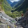
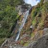
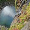
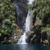
Giro (5 h):
traduzione alternativa
➜
Lingua originale
Gleich nach der Brücke ist der erste hohe freihängende C70. Es gibt mehrere Abseilstände. Die Schönste ist vom Hängestand oro rechts an der Kante, welche ca. 10 m angeklettert bzw. gequert werden muss. Sehr anspruchsvoll zu erreichen. Lässt sich gut von einem der Stände sichern. Danach langes Blockgelände bis zum C130 der oro links 4 mal unterteilt ist. Danach noch einige wirklich schöne Einzelstellen. Die mini trou de fer Passage ist sicher eine der schönsten Stellen im Gebiet. Springen, rutschen und hohe Abseiler mit anspruchsvollen Seilgeländern. Großartige Schlucht. Sicher ein Highlight.
Just after the bridge is the first high free-hanging C70. There are several abseil stands. The most beautiful is from the hanging stand ortographic to the right of the edge, which has to be climbed or traversed for about 10 meters. Very challenging to reach. Can be secured well from one of the belays. Then long boulder terrain to C130, which is divided 4 times ortographic left. After that some really nice single pitches. The mini trou de fer passage is certainly one of the most beautiful spots in the area. Jumps, slides and high rappels with challenging rope traverses. A great canyon. Certainly a highlight.
Ritorno (2 h):
traduzione alternativa
➜
Lingua originale
Das ist wohl der anspruchsvollste Part der Tour. Beim Rückweg ist klettern im min. 3ten Grad erforderlich. Teilweise sind Tritte in die senkrechten Wände geschlagen. Griffe meist natürliche Wurzeln, teilweise Trittklammern. Absolute Trittsicherheit erforderlich. Es sind immer wieder sehr gute Haken gesetzt worden. Der Rückweg ist mit kleinen Schildern (blau weiß mit Inschrift) markiert. Diese sind fast bis zum Schluss vorhanden. Aufpassen auf Bienenstöcke beim Rückweg. Danach Forststraße zur asphaltierten Straße.
This is probably the most challenging part of the tour. Climbing at least 3rd degree is required on the way back. Some of the footholds are cut into the vertical walls. The holds are mostly natural roots, some with footholds. Absolute surefootedness required. There are always very good anchors. The way back is marked with small signs (blue and white with inscription). These are there almost to the end. Watch out for beehives on the way back. Then forest road to the asphalt road.
Coordinate:
Parcheggio Entrata e uscita
-21.11396°, 55.56735°
↓↑
DMS: -22° 53" 9.74', 55° 34" 2.46'
DM: -22° 53.162", 55° 34.041"
Google Maps
DMS: -22° 53" 9.74', 55° 34" 2.46'
DM: -22° 53.162", 55° 34.041"
Google Maps
Fine del canyon
Inizio del canyon
-21.11341°, 55.56743°
↓↑
DMS: -22° 53" 11.72', 55° 34" 2.75'
DM: -22° 53.195", 55° 34.046"
Google Maps
DMS: -22° 53" 11.72', 55° 34" 2.75'
DM: -22° 53.195", 55° 34.046"
Google Maps
Letteratura:
Altro
2017
Ausgewählte Touren ("Klassiker") auf Reunion
Libro Canyoning
Pascal Colas
1995
Libro Canyoning
2009
73 canyons à la Réunion (66) et Madagascar (7)
Libro Canyoning
2002
Info sul canyon Descente
Info sul canyon Ropewiki
Altro info sul canyon
Altro info sul canyon
Rapporto di viaggio (ad es. blogpost)
Altro info sul canyon
Altro info sul canyon
Altro info sul canyon
Altro info sul canyon
29.12.2024
Clarissa Linder
⭐
★★★★★
📖
★★★
⚓
★★★
💧
Normale
Completato ✔
traduzione alternativa
➜
Lingua originale
Altri utenti sono stati: Tobias Beiser Peter Lampacher
Stände inkl. Seilschonern in gutem Zustand. Für den ersten Teil der Schlucht muss man den Neopren noch nicht anziehen (trocken bis nach der zweiten langen Gehpassage). Für den Ausstieg: sobald man die Seilbahn orografisch links sieht, auf der linken Seite nach den Schildern Ausschau halten. Bzw mit GPS-Karten abgleichen.
Kein Empfang in der Schlucht.
Stands including rope protectors in good condition. For the first part of the canyon you don't need to put on the neoprene (dry until after the second long walking passages). For the exit: as soon as you see the cable car orographic left, look for the signs on the left side. Or check with GPS maps.
No reception in the canyon.
Altri utenti sono stati: Tobias Beiser Peter Lampacher
02.10.2023
Rok
⭐
★★★★★
📖
★★★
⚓
★★★
💧
Basso
Completato ✔
traduzione alternativa
➜
Lingua originale
Wenig Wasser. Alle Stände tip top. Ein Highlight mit sehr anspruchsvollen Rückweg. Unbedingt Energie aufsparen für den Ausstieg. Eine der Top Schluchten auf der Insel.
Little water. All stands tip top. A highlight with a very demanding way back. Be sure to save energy for the exit. One of the top gorges on the island.
Nuovo rapporto
Riportare brevemente e concisamente le informazioni più importanti dell'ultimo tour o importanti informazioni attuali sul canyon. Se necessario con link a video, foto, ecc..
*
*
*
Esc
Del
Idrologia: