non così difficile
Serchio di Gramolazzo
v3 a3 ?
6h35
5min
5h30
1h
820m
680m
140m
18m
2x 20m
5
2700m
Auto necessaria
Valutazione:
★★★★★
2.2 (2)
Info:
★★★
0 ()
Belay:
★★★
0 ()
Sintesi:
traduzione alternativa
➜
Lingua originale
Waldschlucht mit Engstellen und interessanter Geologie.
Forest canyon with narrows and interesting geology.
Nord
Sintesi:
traduzione alternativa
➜
Lingua originale
Waldschlucht mit Engstellen und interessanter Geologie.
Forest canyon with narrows and interesting geology.
Accesso:
traduzione alternativa
➜
Lingua originale
Von Lucca über Castelnuovo di Garfagnana in Richtung Norden auf der SR445 bis Piazza al Serchio (oder von Aulla auf gleicher Straße Richtung Süden). Weiter nach Norden und kurz hinter Piazza al Serchio nach links abbiegen auf die SP51 in Richtung Gramolazzo. Den Fiume Serchio überqueren und weiter bis Gramolazzo. In Gramolazzo geradeaus durch den Ort weiter in Richtung Minucciano. Die Straße steigt nun an und nach ca. 3-4 km vor einem Tunnel biegen wir nach links von der SP51 ab in Richtung Refugio Donegani.
Bei der nächsten Verzweigung sehen wir eine Art gemauertes Bushäuschen, ein sog. Rifiugiola. Hier finden wir auch einen Wegweiser, der den "GT 189" mach Südosten bergab weist. Von da kommen wir auf dem Rückweg herauf. Wir stellen hier das untere Auto ab und fahren mit dem zweiten geradeaus weiter. Auf dieser Straße weiter hoch. Nach links unten hat man einen schönen Blick auf die tief unten liegende Waldschlucht des S. di Gramolazzo. Vorbei an einer links unterhalb der Straße gelegenen Picknickanlage. Nach 4,6 km ab Abzweigung Tunnel Auto am Straßenrand abstellen. Westlich darüber am Berghang das Rifugio Donegani, etwa 200m weiter auf der Straße kämen wir zum Rifugio Val Serenaia (1100 alt.).
From Lucca, via Castelnuovo di Garfagnana, head north on the SR445 to Piazza al Serchio (or from Aulla on the same road heading south). Continue north and just past Piazza al Serchio turn left onto the SP51 towards Gramolazzo. Cross the Fiume Serchio and continue until Gramolazzo. In Gramolazzo go straight on through the town towards Minucciano. The road now climbs and after about 3-4 km before a tunnel turn left towards Refugio Donegani. \At the next junction we see a kind of walled bus shelter, a so-called rifiugiola. Here we also find a signpost that indicates the "GT 189" mach southeast downhill. From there we come up on the way back. We park the lower car here and continue straight on with the second one. On this road further up. Going down to the left, we have a beautiful view of the S. di Gramolazzo forest gorge deep below. Pass a picnic area on the left below the road. After 4.6 km from the turnoff before the tunnel, park the car on the side of the road. West above on the mountainside the Rifugio Donegani, about 200m further on the road we would come to the Rifugio Val Serenaia (1100 alt.).
Avvicinamento (5 min):
traduzione alternativa
➜
Lingua originale
Vom Auto direkt in den Bach, ggf. vor dem Zustieg noch einige Meter auf der linken Bachseite abwärts laufen.
From the car directly into the creek, if necessary walk a few meters downhill on the left side of the creek before access.
Giro (5 h 30):
traduzione alternativa
➜
Lingua originale
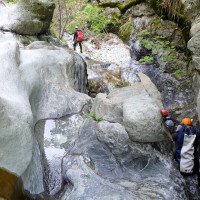
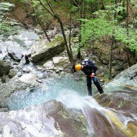
Zu Beginn Ablettern in einer engen, nicht sehr tief eingeschnittenen Felsrinne - 1 Abseiler. Dann fließt der Bach offen im Wald abwärts, unterbrochen von interessanten Engpassagen. Wir passieren ein Ableitungsbauwerk zur Linken. Streckenweise kann man auch im Wald am Bachrand abwärts gehen. Dann klettert und seilt man wieder in Felsrinnen ab.
At the beginning rappeling in a narrow, not very deep rocky gully - 1 rappel. Then the stream flows openly downhill in the forest, interrupted by interesting narrow passages. We pass a diversion structure on the left. In parts you can also go down in the forest at the edge of the stream. Then you climb and rappel again in rock gullies.
Ritorno (1 h):
traduzione alternativa
➜
Lingua originale
Wenn dass Bachbett verflacht und die Einschluchtung zu Ende ist, wenige Minuten noch im Bach, dann links hinaus - etwa. UU passiert man einen Stadel im lichten Niederwald, dann kommt man auf eine große Freifläche. Wir treffen auf einen alten Pfad, der uns in Richtung NNO zum Wanderweg "GT 189" (rote Markierung) führt. Wir folgen ihm links hinauf zur Straße und zum Unterstandshäuschen an der Straße.
When the streambed flattens and the gorge is over, a few more minutes in the gorge, then out to the left - about. UU you pass a barn in the light coppice, then you come to a large open space. We meet an old path that leads us NNO to the hiking trail "GT 189" (red marking). We follow it to the left up to the road and to the shelter on the road.
Coordinate:
Inizio del canyon
Fine del canyon
Parcheggio all'entrata
(descente_3)
Parcheggio in uscita
Letteratura:
Mappa
Edizioni Multigraphic nº 101 Alpi Apuane, 1:25 000
Mappa
IGMI 25/V, 96 Monte Sagro III-NE, 1:25 000
1:25 000
Info sul canyon Cwiki
Info sul canyon Descente
Info sul canyon Ropewiki
09.03.2023
System User
⭐
★★★★★
📖
★★★
⚓
★★★
nessuna traduzione disponibile
Info: Teile der Canyonbeschreibung wurden automatisiert übernommen. Konkret die Felder Weblinks, Koordinaten, Rating, Länge des Canyon, Einfachseil Mindestens von https://www.descente-canyon.com/canyoning/canyon/22486
09.03.2023
System User
⭐
★★★★★
📖
★★★
⚓
★★★
nessuna traduzione disponibile
Daten importiert von https://canyon.carto.net/cwiki/bin/view/Canyons/SerchiodiGramolazzoCanyon.html
Idrologia:


