facile
Siagne de la Pare Escragnolles
v2 a2 II
4h55
25min
3h
1h30
540m
390m
150m
11m
1x 30m
15
1200m
a piedi
Specialità:
§ Regulated
§ Regulated
Valutazione:
★★★★★
3.6 (1)
Info:
★★★
2 (1)
Belay:
★★★
0 ()
Sintesi:
traduzione alternativa
➜
Lingua originale
Abwechslungsreicher Abstieg über Sinterbecken
Varied descent over sinter basins
luglio - settembre
Sud
20.00km²
Sintesi:
traduzione alternativa
➜
Lingua originale
Abwechslungsreicher Abstieg über Sinterbecken
Varied descent over sinter basins
Accesso:
traduzione alternativa
➜
Lingua originale
Von Cannes nimmt man die N 85 nach Grasse und fährt weiter auf der Route Napoléon bis zur Ortschaft Escragnolles (ca. 19 km ab Grasse). Hier geht es auf einer kleinen Straße links hinunter den Wegweisern "Siagne de la Pare" folgend. Die Straße findet ihre Fortsetzung in einer ungeteerten Piste, die im weiteren Verlauf wieder etwas ansteigt. Bevor sie dann steil abfällt, auf einer größeren ebenen Fläche das Auto abstellen (Stahlseil, Lastenaufzug zur Quelle am Gegenhang).
From Cannes, take the N85 to Grasse and continue on the Route Napoléon to the village of Escragnolles (about 19 km from Grasse). Here, take a small road down to the left following the signs "Siagne de la Pare". The road continues on an unpaved track that climbs again a little further on. Before it then drops steeply, park the car on a larger flat area (steel cable, freight elevator to the spring on the opposite slope).
Avvicinamento (25 min):
traduzione alternativa
➜
Lingua originale
Die steil abfallende Piste weiter gehen, vorbei an der Markierung "88". Die Piste findet ihre Fortsetzung in einem Pfad. Bevor(!) man schließlich ein großes Geröllfeld erreicht und vor der großen Info-Tafel gehen rechts hinunter Pfadspuren. Hier hinunter und im weiteren Verlauf den Steinmännchen hinab zum Fluss folgen.
Continue along the steep slope, passing the mark "88". The slope finds its continuation in a path. Before(!) you finally reach a large boulder field and in front of the large information board go right down path tracks. Descend here and follow the cairns further down to the river.
Giro (3 h):
traduzione alternativa
➜
Lingua originale
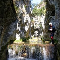
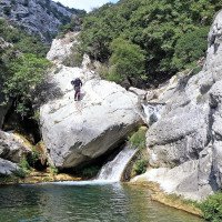
Der Bach fließt über zahllose Sinterterrassen mit durchschnittlich geringem Gefälle dahin, bietet aber auch eine Engstelle und viele Sprungmöglichkeiten. Manchmal lohnt ein Blick hinter den Wasservorhang der versinterten Kaskaden. \nAlso nicht nur landschaftlich attraktiv!
The stream flows over countless sintered terraces with an average low gradient, but also offers a narrow section and many possible jumps. Sometimes it is worth looking behind the water curtain of sintered cascades. \nAlso attractive not only scenic!
Ritorno (1 h 30):
traduzione alternativa
➜
Lingua originale
Früher mußte man die Autos rund 25 km umsetzen, vgl. z.B. "Canyons Méditerranéens - Les plus beaux canyons de l'Ubaye á la mer" (Bernard Barbier/Bernard Ranc) 1993),S. 182; jetzt kann man bei dem Zusammenfluss mit dem anderen Quellfluss der Siagne links hinauf und zurück zum Auto. Dazu geht man zuerst einmal etwa 100 m am orograf. rechten Ufer die andere (Grande)Siagne flussaufwärts. Hier markieren dann Steinmännchen und orange Markierungsstriche eine undeutliche Aufstiegsspur (beginnend in westlicher Richtung!) nordwärts hinauf auf dem Rücken zwischen Siagne de la Pare und Siagne. Mehrere Passagen sind seilgesichert. Nach etwa 45 Min. erreicht man eine Wasserleitung, folgt ihr horizontal nach links, kommt zuerst auf den Zustiegsweg und auf diesem zurück zum Auto (Rückweg 1,5 bis 2 Std.) - vgl.: wikiloc
In the past, one had to move the cars about 25 km, cf. e.g. "Canyons Méditerranéens - Les plus beaux canyons de l'Ubaye á la mer" (Bernard Barbier/Bernard Ranc) 1993),p. 182; now, at the confluence with the other source river of the Siagne, one can go up on the left and back to the car. To do this, first walk about 100 m on the orographic right bank upstream the other (Grande)Siagne. Here, cairns and orange markers mark an indistinct ascent track (starting in western direction!) northwards up the ridge between Siagne de la Pare and Siagne. Several passages are rope-secured. After about 45 min. you reach a water pipe, follow it horizontally to the left, come first on the access path and on this back to the car (return 1.5 to 2 hrs.) - cf.: http://www.randoxygene.org/pge/rando_cc/affiche_rando.php?rubrique=3&zone=2&rando=11¤t=cc-19&ct=cc "visualiser la carte".
Coordinate:
Inizio del canyon
Fine del canyon
Parcheggio Entrata e uscita
Letteratura:
Mappa
3543 ET Haute-Siagne (IGN TOP25), 1/25 000
Libro Canyoning
100 beaux canyons méditerranéens
Jean François Fiorina / Franck Jourdan
2007
Libro Canyoning
Alpes Marítimes. Le Guide du Sportrotter Julien Barthélémy, 2006
Libro Canyoning
Clues & Canyons. Conseil Génerál del Alpes-Maritimes, 2008
2008
Libro Canyoning
L'Aventure verticale dans les Alpes d'Azur. Escalade, canyonisme,
Edisud
1992
9782857445876
Libro Canyoning
Canyons Méditerranéens - Les plus beaux canyons de l'Ubaye á la mer.
Libro Canyoning
L'Aventure verticale dans les Alpes d'Azur. Escalade, canyonisme,
Edisud
1992
9782857445876
Libro Canyoning
France. Espace d´aventure. Gisèle y Pierre Perrod, 1989
Libretto di canyoning
Clues & Canyons. Les Buides Randoxygène Conseil Génerál del Alpes-Maritimes, 2022
2022
https://randoxygene.departement06.fr/publications/guide-randonnees-clues-et-canyons
Info sul canyon Cwiki
Info sul canyon Ropewiki
Gallería
Video
Video
Info sul canyon FFME
Altro info sul canyon
19.04.2023
Daniel Sturm
⭐
★★★★★
📖
★★★
⚓
★★★
Completato ✕
traduzione alternativa
➜
Lingua originale
Koordinaten und Beschreibung bearbeitet.
Coordinates and description edited.
09.03.2023
System User
⭐
★★★★★
📖
★★★
⚓
★★★
nessuna traduzione disponibile
Daten importiert von https://canyon.carto.net/cwiki/bin/view/Canyons/SiagnedelaPareEscragnollesCanyon.html
Idrologia:
nessuna traduzione disponibile
http://pecheursursiagneblogfr.unblog.fr/89/


