un po' difficile
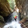
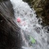
Gei (Inferiore)
Paese:
Schweiz / Switzerland
Regione: Kanton Tessin / Cantone Ticino
Sottoregione: Bezirk Vallemaggia
Città: Gordevio
v4 a4 III
3h35
1h
2h30
5min
480m
340m
140m
28m
2x 50m
10
400m
a piedi
Valutazione:
★★★★★
3.8 (9)
Info:
★★★
2.8 (4)
Belay:
★★★
2.4 (8)
Sintesi:
traduzione alternativa
➜
Lingua originale
Sehr schöne Schlucht; Wasserstand bei Steinbrücke überprüfen; angenehme Länge; tiefe saubere Gumpen; Zustieg nicht leicht.
Very beautiful canyon; check water level at stone bridge; pleasant length; deep clean pools; access not easy.
Parti
Nome
Difficoltà
Avvicinamento
Giro
Ritorno
maggio - settembre
11-16 Ore
Sud
Sintesi:
traduzione alternativa
➜
Lingua originale
Sehr schöne Schlucht; Wasserstand bei Steinbrücke überprüfen; angenehme Länge; tiefe saubere Gumpen; Zustieg nicht leicht.
Very beautiful canyon; check water level at stone bridge; pleasant length; deep clean pools; access not easy.
Accesso:
traduzione alternativa
➜
Lingua originale
Von Locarno --> nach Gordevio hinauf --> nach dem Tunnel noch vor der 2. Brücke bei Haus mit blauen Dach re. hinauf --> vorbei am Fußballplatz --> li. über Brücke --> re. über Pflastersteine bis zur Kirche mit Brunnen --> hier Parken.
From Locarno --> up to Gordevio --> after the tunnel before the 2nd bridge at the house with the blue roof up on the right --> past the soccer field --> left over the bridge --> right over cobblestones to the church with fountain --> park here.
Avvicinamento (1 h):
traduzione alternativa
➜
Lingua originale
Vom Parkplatz (Kirche) an der Steinbrücke Wasserstand Kontrolle --> weiter durch kl. Holztor --> weiter li. am Haus vorbei, die Felsstiegen hoch --> unterhalb der kl. Kapelle den Wanderweg (mit blauen Wellen und Pfeil markiert) immer nach li. folgen --> in einer Kurve den Jägersteig leicht nach unten folgen --> über Zulaufbach wieder steil hinauf bis zur einer Lichtung mit Felsen am Boden --> auf ca. 515Hm den Weg durch steiles Gelände (Fixseile) bis zum Bach --> einsteigen 480Hm.
From the parking lot (church) at the stone bridge check the water level --> continue through the small wooden gate --> continue left past the house, up the rock steps --> below the small chapel follow the hiking trail (marked with blue waves and arrow) always to the left --> in a bend follow the hunters path slightly downhill --> over Zulaufbach again steeply uphill to a clearing with rocks on the ground --> at approx. 515Hm follow the path through steep terrain (fixed ropes) to the stream --> get in 480Hm.
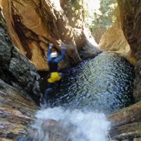
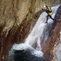
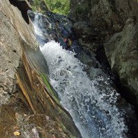
Giro (2 h 30):
traduzione alternativa
➜
Lingua originale
Am Einstieg kommt gleich eine Rutsche (re. Rutschen!) oder C12 --> gleich darauf folgt die nächste Rutsche mit 8m oder C13 --> danach kommen mehrere Gumpen und viele Abseilstellen die auch meist gesprungen werden können (je nach Wasserstand) --> im letzten Drittel kommen die höheren Abseilstellen 20m, 45m, 30m --> die 45m können auch re. über3 Bäume abgeseilt werden oder man seilt sich im Wasser ab bis nach 45m eine Traverse zum 14m Sprung kommt (abseilen vom Baum auch möglich) --> jetzt folgen ein 8m und 30m Abseiler --> die letzte Gumpen können mit dem Seil oder(Springend!) bewältigt werden.
At the entry there is a slide (right slide!) or C12 --> immediately followed by the next slide with 8m or C13 --> after that there are several pools and many abseiling points which can usually be jumped (depending on the water level) --> in the last third there are the higher abseiling points 20m, 45m, 30m --> the 45m can also be abseiled right. The 45m can also be rappelled over 3 trees or you can rappel in the water until after 45m there is a traverse to the 14m jump (rappeling from the tree is also possible) --> now follow an 8m and 30m rappel --> the last pools can be mastered with the rope or (jumping!).
Ritorno (5 min):
traduzione alternativa
➜
Lingua originale
Ausstieg re. direkt bei Kirche (Parkplatz).
Exit right directly at the church (parking lot).
Coordinate:
Inizio del canyon
46.2302°, 8.74776°
↓↑
DMS: 46° 13" 48.72', 8° 44" 51.94'
DM: 46° 13.812", 8° 44.866"
Google Maps
Svizzera Topografica
DMS: 46° 13" 48.72', 8° 44" 51.94'
DM: 46° 13.812", 8° 44.866"
Google Maps
Svizzera Topografica
Fine del canyon
46.2287°, 8.7455°
↓↑
DMS: 46° 13" 43.32', 8° 44" 43.8'
DM: 46° 13.722", 8° 44.73"
Google Maps
Svizzera Topografica
DMS: 46° 13" 43.32', 8° 44" 43.8'
DM: 46° 13.722", 8° 44.73"
Google Maps
Svizzera Topografica
Parcheggio Entrata e uscita
46.22677°, 8.74677°
↓↑
DMS: 46° 13" 36.37', 8° 44" 48.37'
DM: 46° 13.606", 8° 44.806"
Google Maps
Svizzera Topografica
DMS: 46° 13" 36.37', 8° 44" 48.37'
DM: 46° 13.606", 8° 44.806"
Google Maps
Svizzera Topografica
Sito del contatore del livello dell'acqua
46.2289°, 8.74563°
↓↑
DMS: 46° 13" 44.04', 8° 44" 44.27'
DM: 46° 13.734", 8° 44.738"
Google Maps
Svizzera Topografica
DMS: 46° 13" 44.04', 8° 44" 44.27'
DM: 46° 13.734", 8° 44.738"
Google Maps
Svizzera Topografica
Letteratura:
Mappa
1:25000
Libro Canyoning
Associazione Italiana Canyoning
2013
Libro Canyoning
Simon Flower
Cicerone
2012
Northern Italy and Ticino
Libro Canyoning
F. Baumgartner / A. Brunner / D. Zimmermann
2010
Libro Canyoning
Anna Nizzola / Luca Nizzola
2010
Libro Canyoning
Stéphane Coté / Caracal et les Sancho Panza
2008
Libro Canyoning
Matthias Holzinger & Thomas Guigon
Pixartprinting.ch
2020
Info sul canyon Cwiki
Info sul canyon Descente
Info sul canyon Ropewiki
Info sul canyon Swisscanyon
Altro info sul canyon
Info sul canyon ACA
Info sul canyon Schlucht.ch
10.11.2024
Sallemann
⭐
★★★★★
📖
★★★
⚓
★★★
💧
Normale
Completato ✔
nessuna traduzione disponibile
Automatisch importiert von Descente-Canyon.com für Canyon Gei
A surprising high (DC+) waterflow after weeks of no rain; quite slippery; some parts with midday sun; the hiking path gets worse and worse…
(Quelle: https://www.descente-canyon.com/canyoning/canyon-debit/2667/observations.html)
10.11.2024
Sarah Allemann
⭐
★★★★★
📖
★★★
⚓
★★★
nessuna traduzione disponibile
Automatisch importiert von Schlucht.ch für Canyon Valle di Gei inferiore, Wasserstand: "DC+" Verankerungen: "gut"
Erstaunlich hoher Wasserstand nach der längeren Trockenperiode. Teils rutschig, teils mit Mittagssonne. Der Zustiegspfad löst sich immer mehr auf…
(Quelle: https://schlucht.ch/schluchten-der-schweiz-liste/1098-valle-di-gei-inferiore)
05.10.2024
Stephan Gehringer
⭐
★★★★★
📖
★★★
⚓
★★★
💧
Normale
Completato ✔
traduzione alternativa
➜
Lingua originale
05.10.2024
Peisen
⭐
★★★★★
📖
★★★
⚓
★★★
💧
Basso
Completato ✔
traduzione alternativa
➜
Lingua originale
Altri utenti sono stati: Simone Steffke Stephan Gehringer
Alle Rutschen und Sprünge gut machbar
All slides and jumps are easy to do
Altri utenti sono stati: Simone Steffke Stephan Gehringer
26.09.2024
Bavarian Canyoning
⭐
★★★★★
📖
★★★
⚓
★★★
💧
Alto
Completato ✔
traduzione alternativa
➜
Lingua originale


Wir sind bei hohen Wasserstand zu Übungszwecken eingestiegen.
Wegen Wasseranstiegs während der Tour entschieden wir uns dazu vor dem hohen 40er orographisch rechts die Stelle zu umgehen.
Dort wurden einige Haken neu gebohrt, damit man durch die Büsche hinab ins Becken kommt.
Die meisten Becken im oberen Teil vom Inf. waren tief genug zum Springen.
We entered at high water level for practice purposes.
Due to the rise in water during the tour, we decided to bypass the spot orographically to the right before the high 40.
Some new anchors were drilled there so that we could get down through the bushes into the basin.
Most of the pools in the upper part of the inferiore were deep enough to jump.
22.09.2024
patoche67
⭐
★★★★★
📖
★★★
⚓
★★★
💧
Normale
Completato ✔
nessuna traduzione disponibile
Automatisch importiert von Descente-Canyon.com für Canyon Gei
Un amarrage défectueux peu avant la C45. Le deuxième point est ok.Le débit permettait de descendre la C45 sans prendre la déviation.Nous avons enlevé 20m de corde bloqués par une équipe précédente.Par la C30, il me manquait 2m aavec une 60.
(Quelle: https://www.descente-canyon.com/canyoning/canyon-debit/2667/observations.html)
15.09.2024
Jo1865
⭐
★★★★★
📖
★★★
⚓
★★★
💧
Normale
Completato ✔
nessuna traduzione disponibile
Automatisch importiert von Descente-Canyon.com für Canyon Gei
Top conditions
(Quelle: https://www.descente-canyon.com/canyoning/canyon-debit/2667/observations.html)
14.09.2024
tristan0x
⭐
★★★★★
📖
★★★
⚓
★★★
💧
Normale
Completato ✔
nessuna traduzione disponibile
Automatisch importiert von Descente-Canyon.com für Canyon Gei
Bonne entrée en matière quand on découvre le Tessin. DC-
(Quelle: https://www.descente-canyon.com/canyoning/canyon-debit/2667/observations.html)
01.09.2024
Patrik B
⭐
★★★★★
📖
★★★
⚓
★★★
nessuna traduzione disponibile
Automatisch importiert von Schlucht.ch für Canyon Valle di Gei inferiore, Wasserstand: "Niedrig" Verankerungen: "Ok"
Mittlerweilen gibt es nach dem Abzweig zahlteiche in die Irre führende Wege...
(Quelle: https://schlucht.ch/schluchten-der-schweiz-liste/1098-valle-di-gei-inferiore)
01.09.2024
Bina
⭐
★★★★★
📖
★★★
⚓
★★★
💧
Normale
Completato ✔
nessuna traduzione disponibile
Automatisch importiert von Descente-Canyon.com für Canyon Gei
DC - -
(Quelle: https://www.descente-canyon.com/canyoning/canyon-debit/2667/observations.html)
01.09.2024
Bina
⭐
★★★★★
📖
★★★
⚓
★★★
💧
Basso
Completato ✔
traduzione alternativa
➜
Lingua originale
Altri utenti sono stati: Patrik Bartel
Erstaunlich griffiger Fels.
Leider gibt es nach dem Abzweig zahlteiche in die Irre führenden Wege.
Amazingly grippy rock.
Unfortunately, after the junction there are numerous paths that lead you astray.
Altri utenti sono stati: Patrik Bartel
28.08.2024
freecanyon
⭐
★★★★★
📖
★★★
⚓
★★★
💧
Normale
Completato ✔
nessuna traduzione disponibile
Automatisch importiert von Descente-Canyon.com für Canyon Gei
(Quelle: https://www.descente-canyon.com/canyoning/canyon-debit/2667/observations.html)
22.08.2024
jerome-g
⭐
★★★★★
📖
★★★
⚓
★★★
💧
Normale
Completato ✔
nessuna traduzione disponibile
Automatisch importiert von Descente-Canyon.com für Canyon Gei
Peut-être DC- si j'interprète bien la photo d'Eldorado. C'est joli, l'eau est belle, il y a des vasques gigantesques mais peu de sauts/tob pour nous. Effectivement pour l'accès, comme précisé dans une obs précédente, il faut monter raide à droite après avoir croisé l'affluent sec (une sente semble continuer à flanc).
(Quelle: https://www.descente-canyon.com/canyoning/canyon-debit/2667/observations.html)
16.08.2024
Bilgeri Rudi
⭐
★★★★★
📖
★★★
⚓
★★★
nessuna traduzione disponibile
Automatisch importiert von Schlucht.ch für Canyon Valle di Gei inferiore, Wasserstand: "mittel" Verankerungen: "alle Stände ok"
Zustieg ziemlich rutschig
(Quelle: https://schlucht.ch/schluchten-der-schweiz-liste/1098-valle-di-gei-inferiore)
16.08.2024
tropyk
⭐
★★★★★
📖
★★★
⚓
★★★
💧
Normale
Completato ✔
nessuna traduzione disponibile
Automatisch importiert von Descente-Canyon.com für Canyon Gei
dc-
(Quelle: https://www.descente-canyon.com/canyoning/canyon-debit/2667/observations.html)
12.08.2024
Taffon
⭐
★★★★★
📖
★★★
⚓
★★★
💧
Normale
Completato ✔
nessuna traduzione disponibile
Automatisch importiert von Descente-Canyon.com für Canyon Gei
RAS
(Quelle: https://www.descente-canyon.com/canyoning/canyon-debit/2667/observations.html)
02.08.2024
Hugoze
⭐
★★★★★
📖
★★★
⚓
★★★
💧
Normale
Completato ✔
nessuna traduzione disponibile
Automatisch importiert von Descente-Canyon.com für Canyon Gei
On s est un peu paumés sur la MA et on est pas les seuls vu les traces. A l oratoire prendre a gauche la sente horizontale bien marquée jusqu a arriver a un affluent sec (100m grosso merdo). On grimpe dans le talus a droite, trace peu visible. On rejoint ensuite le sommet de la crête et on reprolonge horizontalement vers la gauche. Les 5 premiers obstacles sont ok en tob ou sauts. Ensuite mieux vaut utiliser la corde 2h20 a 4 voiture a voiture . Complété avec val grande et maggia
(Quelle: https://www.descente-canyon.com/canyoning/canyon-debit/2667/observations.html)
01.08.2024
Hydro-puledro
⭐
★★★★★
📖
★★★
⚓
★★★
💧
Normale
Completato ✔
nessuna traduzione disponibile
Automatisch importiert von Descente-Canyon.com für Canyon Gei
Sempre bellissimo.La sosta della calata con sosta a sinistra (10 MT) ha uno spit uscito per metà, il secondo è ancora buono.
(Quelle: https://www.descente-canyon.com/canyoning/canyon-debit/2667/observations.html)
27.07.2024
RomAnna
⭐
★★★★★
📖
★★★
⚓
★★★
💧
Normale
Completato ✔
nessuna traduzione disponibile
Automatisch importiert von Descente-Canyon.com für Canyon Gei
RAS
(Quelle: https://www.descente-canyon.com/canyoning/canyon-debit/2667/observations.html)
22.07.2024
Lucki
⭐
★★★★★
📖
★★★
⚓
★★★
nessuna traduzione disponibile
Automatisch importiert von Schlucht.ch für Canyon Valle di Gei inferiore, Wasserstand: "niedrig" Verankerungen: "OK (inox)"
(Quelle: https://schlucht.ch/schluchten-der-schweiz-liste/1098-valle-di-gei-inferiore)
22.07.2024
SandroS
⭐
★★★★★
📖
★★★
⚓
★★★
💧
Normale
Completato ✔
traduzione alternativa
➜
Lingua originale
An einem Stand orographisch links (Dopelstand) ist der Schlaganker Lose und der 2. Anker halb halb raus und verbogen. Müsste mal ersetzt werden
On one stand orographically to the left (Dopelstand), the anchor is loose and the 2nd anchor is halfway out and bent. It would have to be replaced
29.06.2024
Peisen
⭐
★★★★★
📖
★★★
⚓
★★★
💧
Normale
Completato ✔
traduzione alternativa
➜
Lingua originale
Zustieg wild und nicht einfach zu finden. Nur zu empfehlen, wenn man den zustieg kennt.
Guter canyon 😀
Gut zu kombinieren mit Val Grande.
Griffig zu gehen und alle rutschen und Sprünge machbar
Wild access and not easy to find. Only recommended if you know the access.
Good canyon 😀
28.05.2024
Corsac
⭐
★★★★★
📖
★★★
⚓
★★★
💧
Alto
Completato ✔
nessuna traduzione disponibile
Automatisch importiert von Descente-Canyon.com für Canyon Gei
On a contourné la C45 en RD (remonter 15-20m) car le débit était trop élevé. Un rappel sur un arbre et ensuite, 2 autres rappels sur cordes/sangles avec maillon. Ça chasse bien en C30. Quasiment tous les rappels de font dans l'eau (pas de possibilité de les faire hors d'eau) Joli canyon. Approche RAS( selon le Topo).
(Quelle: https://www.descente-canyon.com/canyoning/canyon-debit/2667/observations.html)
25.06.2023
Patrik Bartel
⭐
★★★★★
📖
★★★
⚓
★★★
💧
Normale
Completato ✔
traduzione alternativa
➜
Lingua originale
Der Weg ist ziemlich zugewachsen, wer nicht weiss, wo dieser verlaufen sollte, sucht etwas länger.
Im Gegensatz zu anderen Canyons im Tessin noch wenig rutschig.
The path is quite overgrown, who does not know where this should run, search a little longer.
Unlike other canyons in Ticino still little slippery.
05.04.2023
Daniel Sturm
⭐
★★★★★
📖
★★★
⚓
★★★
Completato ✕
traduzione alternativa
➜
Lingua originale
Koordinaten und Beschreibung angepasst. Canyons zusammengeführt.
Coordinates and description adjusted. Canyons merged.
09.03.2023
System User
⭐
★★★★★
📖
★★★
⚓
★★★
nessuna traduzione disponibile
Daten importiert von https://canyon.carto.net/cwiki/bin/view/Canyons/ValdiGeiinferioreCanyon.html
Nuovo rapporto
Riportare brevemente e concisamente le informazioni più importanti dell'ultimo tour o importanti informazioni attuali sul canyon. Se necessario con link a video, foto, ecc..
*
*
*
Esc
Del