Paese:
Schweiz / Switzerland
Regione: Kanton Tessin / Cantone Ticino
Sottoregione: Bezirk Locarno
Città: Vira (Gambarogno)
v4 a3 III
5h55
50min
5h
5min
520m
210m
310m
32m
2x 35m
11
1700m
Auto facoltativa
Specialità:
§ Regulated
§ Regulated
Valutazione:
★★★★★
2.4 (4)
Info:
★★★
2 (3)
Belay:
★★★
2 (3)
Sintesi:
traduzione alternativa
➜
Lingua originale
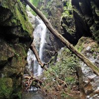
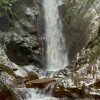
Urige Waldschlucht
Pristine forest gorge
giugno - settembre
10-15 Ore
Nord
7.48km²
Sintesi:
traduzione alternativa
➜
Lingua originale
Urige Waldschlucht
Pristine forest gorge
Accesso:
traduzione alternativa
➜
Lingua originale
Wir verlassen dia A 2 auf der Ausfahrt Bellinzona Süd und fahren 7,8 km in Richtung Locarno. Am Kreisel in Quartino nehmen wir nicht die erste Ausfahrt nach Locarno, sondern die zweite in Richtung Vira, Gerra. Wir fahren nach einiger Zeit am Südostufer des Lago Maggiore entlang und kommen dann nach Vira (Gambarogno). Hier stellen wir das untere Auto ab. \nMit dem zweiten (oder dem Postbus - Abfahrt 08.35 - 2008) fahren wir von der Küstenstraße weg und bergauf in Richtung Monti di Fosano. Nach 4,7 km, bei der Straßenkehre, wo die Straße aus Richtung NNO kommend in Richtung NNW schwenkt, Auto abstellen (Höhe 640 m üNN). Hier ist auch eine Postbushaltestelle ("Monti di Fosano-Monti").
We leave the A2 at the Bellinzona Sud exit and drive 7.8 km in the direction of Locarno. At the traffic circle in Quartino we do not take the first exit to Locarno, but the second one towards Vira, Gerra. After a while we drive along the south-eastern shore of Lake Maggiore and then we come to Vira (Gambarogno). Here we park the lower car. \nWith the second one (or the post bus - departure 08.35 - 2008) we leave the coastal road and go uphill towards Monti di Fosano. After 4.7 km, at the bend in the road where the road turns NNW coming from the NNO direction, park the car (altitude 640 m above sea level). Here is also a post bus stop ("Monti di Fosano-Monti").
Avvicinamento (50 min):
traduzione alternativa
➜
Lingua originale
Vom Auto nehmen wir zunächst den Pfad in südlicher Richtung, dann nach der Brücke gehen wir in Richtung ONO weglos bergab zu einem Einzelhaus auf der Hangkante ("Nebbia"-548 m üNN). Von hier in südöstlicher Richtung auf "Wegspuren" oder weglos zum Bach.
Man kann von dem Haus auch auf der Hangkante absteigen und dann beim Zusammenfluss des Vira mit dem von links kommenden Bach hineinseilen.
From the car we first take the path in southern direction, then after the bridge we go downhill in direction ONO without any path to a single house on the edge of the slope ("Nebbia"-548 m a.s.l.). From here, in a southeasterly direction on "tracks" or pathless to the stream.\nYou can also descend from the house on the edge of the slope and then rope in at the confluence of the Vira with the stream coming from the left.
Giro (5 h):
traduzione alternativa
➜
Lingua originale
Abwechselnd Abseiler und Sprungmöglichkeiten, Glattes Geläuf. Einige nicht verifizierte Notausstiegsmöglichkeiten. Begehung nur vom 1. Mai bis 1. Oktober erlaubt.
Alternating rappel and possible jumps, Smooth terrain. Some unverified emergency exits. Climbing allowed only from May 1 to October 1.
Ritorno (5 min):
traduzione alternativa
➜
Lingua originale
In Vira links hinaus zur Straße.
In Vira turn left out to the road.
Coordinate:
Inizio del canyon
46.1307°, 8.84492°
↓↑
DMS: 46° 7" 50.52', 8° 50" 41.71'
DM: 46° 7.842", 8° 50.695"
Google Maps
Svizzera Topografica
DMS: 46° 7" 50.52', 8° 50" 41.71'
DM: 46° 7.842", 8° 50.695"
Google Maps
Svizzera Topografica
Fine del canyon
46.1423°, 8.8423°
↓↑
DMS: 46° 8" 32.28', 8° 50" 32.28'
DM: 46° 8.538", 8° 50.538"
Google Maps
Svizzera Topografica
DMS: 46° 8" 32.28', 8° 50" 32.28'
DM: 46° 8.538", 8° 50.538"
Google Maps
Svizzera Topografica
Sito del contatore del livello dell'acqua
46.14175°, 8.84294°
↓↑
DMS: 46° 8" 30.3', 8° 50" 34.58'
DM: 46° 8.505", 8° 50.576"
Google Maps
Svizzera Topografica
DMS: 46° 8" 30.3', 8° 50" 34.58'
DM: 46° 8.505", 8° 50.576"
Google Maps
Svizzera Topografica
Parcheggio in uscita
46.14349°, 8.84035°
↓↑
DMS: 46° 8" 36.56', 8° 50" 25.26'
DM: 46° 8.609", 8° 50.421"
Google Maps
Svizzera Topografica
DMS: 46° 8" 36.56', 8° 50" 25.26'
DM: 46° 8.609", 8° 50.421"
Google Maps
Svizzera Topografica
Parcheggio all'entrata
46.1314°, 8.84052°
↓↑
DMS: 46° 7" 53.04', 8° 50" 25.87'
DM: 46° 7.884", 8° 50.431"
Google Maps
Svizzera Topografica
DMS: 46° 7" 53.04', 8° 50" 25.87'
DM: 46° 7.884", 8° 50.431"
Google Maps
Svizzera Topografica
Letteratura:
Mappa
1:25000
Libro Canyoning
Anna Nizzola / Luca Nizzola
2010
Libro Canyoning
Andreas Brunner / Frédéric Bétrisey
SAC Schweizer Alpenclub
2001
978-3859021952
Libro Canyoning
Matthias Holzinger & Thomas Guigon
Pixartprinting.ch
2020
Info sul canyon Cwiki
Info sul canyon Descente
Info sul canyon Ropewiki
Info sul canyon Swisscanyon
Info sul canyon Schlucht.ch
Altro info sul canyon
16.09.2024
Marco Brack
⭐
★★★★★
📖
★★★
⚓
★★★
nessuna traduzione disponibile
Automatisch importiert von Schlucht.ch für Canyon Valle di Vira inferiore, Wasserstand: "niedrig" Verankerungen: "gut"
Wir sind bei westlichen Zulaufs eingesteigen Punkt 620 MüM (2708346 1109684). z.T. viel Holz im unteren Bereich des Zufluss. Bereich Zufluss ist etwa so aufgebaut (alles Schätzungen): 50m... ; C8; C8; C8+C7; 20m... (viel Holz); C5+C7; 20m... ; C8; C5+C4+C5; 50m links...; C8 an Baum; C15 Baum links (Holz versprerrt Inox); Zusammenfluss.
(Quelle: https://schlucht.ch/schluchten-der-schweiz-liste/1009-valle-di-vira-inferiore)
13.08.2024
Simone Steffke
⭐
★★★★★
📖
★★★
⚓
★★★
💧
Basso
Completato ✔
traduzione alternativa
➜
Lingua originale
Einstieg über Nebenarm, extrem viel Holz. Ab Zusammenfluss ok. Relativ griffig in den Gehpassagen, in den Abseilern etwas rutschig.
Entry via side arm, lots of wood. From the confluence ok. Relatively good grip in the walking passages, somewhat slippery in the rappels.
04.06.2024
Matthias Holzinger
⭐
★★★★★
📖
★★★
⚓
★★★
💧
Normale
Completato ✔
traduzione alternativa
➜
Lingua originale
Alles gut, viele Sprünge & Rutschen möglich.
Eher rutschig und zwischendurch viele Lauf & Kletterpassagen.
All good, many jumps & slides possible.
Rather slippery and in between many walk and climbing passages.
10.06.2023
Fred
⭐
★★★★★
📖
★★★
⚓
★★★
💧
Normale
Completato ✔
traduzione alternativa
➜
Lingua originale
Einstieg über Nebenarm, Stände in Ordnung, sehr rutschig und viel Holz
Entry via side arm, stands okay, very slippery and lots of wood
05.04.2023
Daniel Sturm
⭐
★★★★★
📖
★★★
⚓
★★★
Completato ✕
traduzione alternativa
➜
Lingua originale
Koordinaten und Beschreibung bearbeitet.
Coordinates and description edited.
09.03.2023
System User
⭐
★★★★★
📖
★★★
⚓
★★★
nessuna traduzione disponibile
Daten importiert von https://canyon.carto.net/cwiki/bin/view/Canyons/VirainferioreCanyon.html
Nuovo rapporto
Riportare brevemente e concisamente le informazioni più importanti dell'ultimo tour o importanti informazioni attuali sul canyon. Se necessario con link a video, foto, ecc..
*
*
*
Esc
Del