non così difficile
Schellaine inf.
Paese:
Deutschland / Germany
Regione: Oberbayern / Upper Bavaria
Sottoregione: Landkreis Garmisch-Partenkirchen
Città: Garmisch-Partenkirchen
v3 a3 III
2h15
35min
1h20
20min
1000m
860m
140m
15m
2x20m
9
350m
a piedi
Specialità:
riserva naturale
riserva naturale
Valutazione:
★★★★★
3 (2)
Info:
★★★
2 (1)
Belay:
★★★
2 (2)
Sintesi:
traduzione alternativa
➜
Lingua originale
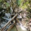
Alpine Schlucht, unterer Abschnitt, durchgehend eng, idR viel Totholz, kleinere Abseiler
Alpine canyon, lower part, narrow throughout, usually lots of dead wood, smaller rappels
Sud
Sintesi:
traduzione alternativa
➜
Lingua originale
Alpine Schlucht, unterer Abschnitt, durchgehend eng, idR viel Totholz, kleinere Abseiler
Alpine canyon, lower part, narrow throughout, usually lots of dead wood, smaller rappels
Accesso:
traduzione alternativa
➜
Lingua originale
Ausgangspunkt ist die Ortschaft Griesen im Loisachtal an der Verbindungsstraße Garmisch-Partenkirchen - Ehrwald/Lermoos. Die Ortschaft liegt etwa 1200m nordöstlich der deutsch-österreichischen Grenze. Parkmöglichkeit auf beiden Seiten der Brücke.
The starting point is the village of Griesen in the Loisach Valley on the Garmisch-Partenkirchen - Ehrwald/Lermoos connecting road. The village is located about 1200m northeast of the German-Austrian border. Parking is possible on both sides of the bridge.
Avvicinamento (35 min):
traduzione alternativa
➜
Lingua originale
Wir starten östlich der Brücke über die Neidernach, die wenige Meter unterhalb in die Loisach mündet. Wir nehmen die Forststraße am orograf. linken Ufer der Neidernach und wandern flussaufwärts, vorbei an einer Feldkapelle. Wir queren den Nudelgraben und die Sunkenlaine. 1000m nach Beginn des Weges und 140m nach Querung der Sunkenlaine biegen wir rechts ab auf grobe Fahrzeugspuren im Morast (an Baum zwei kleine Wegweiser ohne Aufschrift in diametraler Richtung). Wir folgen dem "Weg", der später zum Steig wird, bergauf. Auf Höhe 950 üNN verzweigt sich der Steig. Links (Wegweisung "Schellalm"-"251") geht es nun in wenigen Metern zum Steg über die Schellaine. Zum Einstieg queren wir von der nächsten Linkskehre des Steiges etwas heikel über dem Schluchtabfall hinüber ins Bachbett (Es empfiehlt sich hier vorsorglich ein Handlauf).
We start east of the bridge over the Neidernach, which flows into the Loisach a few meters below. We take the forest road on the orographic left bank of the Neidernach and hike upstream, past a field chapel. We cross the Nudelgraben and the Sunkenlaine. 1000m after the start of the path and 140m after crossing the Sunkenlaine, we turn right onto rough vehicle tracks in the mire (two small signposts without inscriptions on trees in diametrical directions). We follow the "path", which later becomes a path, uphill. At 950 m above sea level, the path branches off. Turn left (signposted "Schellalm"-"251") and in a few meters you reach the footbridge over the Schellaine. For entry, we cross somewhat precariously from the next leftward haipin bend of the path over the gorge drop into the streambed (a handrail is recommended here as a precaution).
Giro (1 h 20):
traduzione alternativa
➜
Lingua originale
Kleinere Abseiler, mehrmals Abklettern über Totholz. Siehe Fotos und Videos.
Smaller rappels, several downclimbs over deadwood. See photos and videos.
Ritorno (20 min):
traduzione alternativa
➜
Lingua originale
Dem Bachbett bis zur Forststraße folgen und auf dieser zurück zum Parkplatz.
Follow the streambed to the forest road and return on it to the parking lot.
Coordinate:
Inizio del canyon
Zustieg von der Westseite der Brücke, hier auch Ausstiegsmöglichkeit nach Begehung des oberen Abschnitts
Fine del canyon
nach Ende der Einschluchtung bei Erreichen des breiten Kiesbettes
Parcheggio Entrata e uscita
Letteratura:
Mappa
1:25000
Libro Canyoning
Werner Baumgarten
2013
Libro Canyoning
Werner Baumgarten
2010
Info sul canyon Cwiki
Info sul canyon Descente
Info sul canyon Ropewiki
Gallería
24.08.2024
Manfred Reg
⭐
★★★★★
📖
★★★
⚓
★★★
💧
Basso
Completato ✔
traduzione alternativa
➜
Lingua originale

Am Anfang hat es ausgeschaut ob der Bach trocken ist,er verschwindet aberweiter oben im Bachbett..Wir haben einen Zustieg eine Kurve weiter oben gewählt , .Hacken noch alle vorhanden,, Bohrhaken sind fest aber angerostet.Sehr viel Holz ,könnte bei höheren Wasserständen problematisch werden.
At the beginning it looked like the stream was dry, but it disappears further up in the streambed. We chose an access one bend further up, all hooks are still there, hooks are firm but rusty, a lot of wood, could be problematic at higher water levels.
21.10.2023
Wolfgang Streicher
⭐
★★★★★
📖
★★★
⚓
★★★
💧
Basso
Completato ✔
traduzione alternativa
➜
Lingua originale
Bei der etwas heiklen Querung vom Steig in das Bachbett Handlauf angebracht. Haken ok.
Überwiegend Sonneneinfall in der Schlucht. Ideale Einstiegszeit wäre insoweit 11.15(Sommerzeit).
Totholz bei diesem relativ geringen Wasserdurchsatz kein Problem.
At the somewhat tricky traverse from the climb into the creek bed handrail attached. Hooks ok.
Predominantly sunshine in the gorge. Ideal entry time would be 11.15(summer time) in this respect.
Deadwood not a problem at this relatively low water flow.
Nuovo rapporto
Riportare brevemente e concisamente le informazioni più importanti dell'ultimo tour o importanti informazioni attuali sul canyon. Se necessario con link a video, foto, ecc..
*
*
*
Esc
Del
Idrologia:


