difficile
Grotta Donini
Paese:
Italia / Italy
Regione: Sardegna
Sottoregione: provincia dell'Ogliastra / Province of Ogliastra
Città: Urzulei
v5 a3 V
3h15
10min
2h30
35min
700m
550m
150m
50m
2x50m, 1x30m
6
900m
a piedi
Valutazione:
★★★★★
4.8 (9)
Info:
★★★
3 (4)
Belay:
★★★
2.7 (6)
Sintesi:
traduzione alternativa
➜
Lingua originale
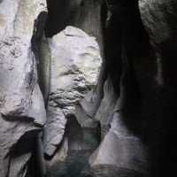
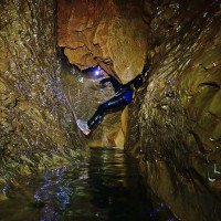
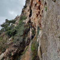
Abgeschiedener, landschaftliche beeindruckender Umgebung; Wunderschöne ausgewaschene Kalkfelsen im Inneren der Höhle. Viele schöne Versinterungen (Stalagmiten, Stalaktiten, Becken); Zählt zu den Top-Ten der Canyons von Sardinien. 50m Schlusswasserfall; Gute Wasserdichte Lampen und warmen Neopren verwenden; Nur bei sehr stabilen Wetter einsteigen; Kombinierbar mit Cordula Orbisi (fast gleicher Rückweg); Inox Standplätze; Kaltes Wasser; einige rutschige Stellen; Orientierung nicht immer leicht. Exposition: Nord; Bach von Grotta Donini mündet wie Cordula Orbisi in Rio Flumineddu
Secluded, scenic surroundings; Beautiful eroded limestone rocks inside the cave. Many beautiful sinterings (stalagmites, stalactites, basins); Counts among the top ten canyons of Sardinia. 50m final waterfall; Use good waterproof lamps and warm neoprene; Enter only in very stable weather; Can be combined with Cordula Orbisi (almost the same way back); Inox stances; Cold water; Some slippery places; Orientation not always easy. Exposure: North; stream from Grotta Donini flows into Rio Flumineddu like Cordula Orbisi.
Nord
Sintesi:
traduzione alternativa
➜
Lingua originale
Abgeschiedener, landschaftliche beeindruckender Umgebung; Wunderschöne ausgewaschene Kalkfelsen im Inneren der Höhle. Viele schöne Versinterungen (Stalagmiten, Stalaktiten, Becken); Zählt zu den Top-Ten der Canyons von Sardinien. 50m Schlusswasserfall; Gute Wasserdichte Lampen und warmen Neopren verwenden; Nur bei sehr stabilen Wetter einsteigen; Kombinierbar mit Cordula Orbisi (fast gleicher Rückweg); Inox Standplätze; Kaltes Wasser; einige rutschige Stellen; Orientierung nicht immer leicht. Exposition: Nord; Bach von Grotta Donini mündet wie Cordula Orbisi in Rio Flumineddu
Secluded, scenic surroundings; Beautiful eroded limestone rocks inside the cave. Many beautiful sinterings (stalagmites, stalactites, basins); Counts among the top ten canyons of Sardinia. 50m final waterfall; Use good waterproof lamps and warm neoprene; Enter only in very stable weather; Can be combined with Cordula Orbisi (almost the same way back); Inox stances; Cold water; Some slippery places; Orientation not always easy. Exposure: North; stream from Grotta Donini flows into Rio Flumineddu like Cordula Orbisi.
Accesso:
traduzione alternativa
➜
Lingua originale
Von Arbatax auf der SS125 in Richtung Norden (Olbia) weiter in den Ort Lozzorei; nach der Esso Tankstelle links abbiegen auf die SP56 (Via Milano); Straße längere Zeit folgen; bei der Gabelung rechts Ri. Urzulei; Hauptstraßenverlauf (SP37) für ca 15 km folgen, durch Urzulei fahren, den Berg nach Urzulei hinauf und dann links auf die SS125 in Richtung Dorgali abbiegen. Nun folgt man der Bergstraße bis zur der schon von weitem sichtbaren Felswand (rechts befindet sich ein markantes Gebäude) – Hier links abbiegen. Man folgt der asphaltierten Straße für ca 1 km (unter der markanten Felswand um den Berg herum), danach wird die Straße für 21km zur Off-road-Piste (man befindet sich auf einer Hochebene) – von hier sind es noch ca 40 min.(zum Einstiegsparkplatz). Bei der ersten Abzweigung rechts halten und bei der Gabelung mit Schild (aufgesprühte Schrift) links halten. Nach der Gabelung zieht die Straße nach unten, nach zwei markanten Kurven fährt man über eine Überfahrt )ausgetrocknetes Bachbett). Nach der Überfahrt dem Hauptverlauf der Straße durch das bewaldete Gebiet (vorbei an einem Haus mit Schild „Grotta Donini/Orbisi“ ) für längere Zeit folgen bis zum Ende der Pflasterstraße wo sich ein Umkehrplatz mit 2 Bäumen in der Mitte befindet. Hier parken (780m).
Von Dorgali auf der SS125 in Richtung Passo Genna Siliana. Nach dem Pass noch einige Kilometer weiter bis nach mehreren Steinschlaggallerien eine Asphaltstrasse rechts abzweigt. Auf dieser Strasse unter Felswänden bis zu einer Hochebene. Hier rechts halten und auf einer Sandstrasse Richtung Norden fahren. Die Strasse ist gerade noch mit normalen Fahrzeugen befahrbar - allzu tief sollte die Bodenplatte aber nicht liegen. Eine zerstörte Brücke muss im Bachbett umfahren werden. Nach einigen Kilometern sieht man rechts ein abgezäuntes Gebäude - Campos Bargios. Hier noch etwa 2km geradeaus weiter bis rechts eine Informationstafel über Höhlen im Bachbett der Codula Orbisi auftaucht - Parkmöglichkeit für mehrere Autos. \nMan kann auch noch weiter hinunter fahren bis , wenn man die Steilheit der gepflasterter Straße nicht scheut. Wo die Pflasterung dann aufhört, große Fläche zum Abstellen des Autos - 2,5 km ab Campos Bargios(782m üNN).
From Arbatax take the SS125 north (Olbia) to the town of Lozzorei; after the Esso gas station turn left onto the SP56 (Via Milano); follow the road for a long time; at the fork turn right towards Urzulei; follow the main road (SP37) for about 15 km, drive through Urzulei, up the mountain to Urzulei and then turn left onto the SS125 towards Dorgali. Now follow the mountain road until you reach the rock face that can be seen from afar (there is a prominent building on the right) - Turn left here. Follow the asphalt road for about 1 km (under the prominent rock wall around the mountain), then the road becomes an off-road track for 21 km (you are on a plateau) - from here it is about 40 min. (to the parking entry). At the first fork keep right and at the fork with signs (sprayed writing) keep left. After the fork, the road goes down, after two prominent bends, you will cross a crossing )dried streambed). After the crossing, follow the main course of the road through the wooded area (passing a house with a sign "Grotta Donini/Orbisi" ) for a long time until the exit of the paved road where there is a turnaround area with 2 trees in the middle. Park here (780m).
From Dorgali take the SS125 in the direction of Passo Genna Siliana. After the mountain pass continue for a few kilometers until, after several rockfall galleries, an asphalt road branches off to the right. Follow this road under rocky walls until you reach a plateau. Here keep right and drive north on a sand road. The road is just passable with normal vehicles - but the bottom plate should not be too deep. A destroyed bridge has to be bypassed in the streambed. After a few kilometers you will see a fenced off building on the right - Campos Bargios. Continue straight on for about 2km until you see an information board on the right about caves in the streambed of Codula Orbisi - parking for several cars. \nMan can also continue down until , if you are not afraid of the steepness of the paved road. Where the pavement then stops, large area to park the car - 2.5 km from Campos Bargios(782m above sea level).
Avvicinamento (10 min):
traduzione alternativa
➜
Lingua originale
Vom Parkplatz/Umkehrplatz rechst ein bisschen bergauf, vorbei an dem eingezäunten Grundstück mit markantem runden Gebäude mit Holzdach. Hier zum Bach Cordula Orbisi absteigen, den man in Kürze erreicht (750m). Im Bachbett haltet man nach ca 5min auf der rechten Seite Ausschau nach dem kleinen Einstiegsloch (1x 1m) (bei unserer Begehung unter einem umgefallenen Baum) (Sanduhr + 2 Inox Klebehaken).
Für den oberen Parkplatz: Den mit Steinmännern markierten und mit Seilen gesicherten Weg bis in trockene Bachbett folgen, dann noch etwa 15min im Bachbett absteigen. Nach einer breiteren Passage verengt sich das Bachbett etwas - der sehr unscheinbare Höhleneingang befindet sich auf der orographisch rechten Bachseite etwa 2m oberhalb der Bachsohle unterhalb eines großen Baums.\nFür den unteren Parkplatz: Die Mulde in östlicher Richtung hinauf (linkerhand ein Schafstall mit der typ. Behausung der Schäfer, eine Art "Tiki" aus Holz -Sedda Ar Baccas) und oben angekommen, den deutlichen Spuren jenseits hinunter folgen in's Bachbett. Dieses etwa 100m nach links abwärts (ca. 5 Min.), dann kommen wir zu dem oben beschriebenen Einlass zur Höhle.
From the car park/turning point, go uphill a little on the right, past the fenced-in property with a striking round building with a wooden roof. Descend to the Cordula Orbisi stream, which you will reach shortly (750m). In the streambed, after about 5 minutes, look out on the right for the small entry hole (1x 1m) (during our climb under a fallen tree) (hourglass + 2 Inox glued anchors).
For the upper parking lot: follow the path marked with cairns and secured with ropes until you reach the dry streambed, then descend for about 15min in the streambed. After a wider passage, the streambed narrows somewhat - the very inconspicuous cave entrance is located on the orographic right side of the stream about 2m above the streambed below a large tree.\nFor the lower parking lot: Up the hollow in an easterly direction (left hand a sheepfold with the typ. On the left hand side a sheepfold with the typical dwelling of the shepherds, a kind of "Tiki" made of wood - Sedda Ar Baccas) and arrived at the top, follow the clear tracks beyond down into the streambed. Follow the creek for about 100m downhill to the left (about 5 min.), then you will reach the entrance to the cave described above.
Giro (2 h 30):
traduzione alternativa
➜
Lingua originale
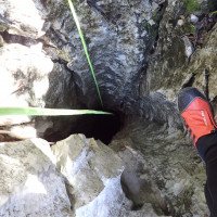
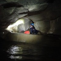
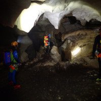
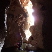
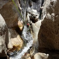
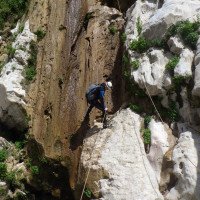
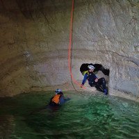
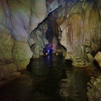
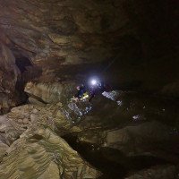
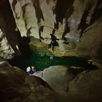
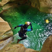
Nach dem engen, trockenen Abseiler in die Höhle (7m) NICHT dem roten Pfleil folgen, sondern rechts durch den kleinen Durchschlupf zu der nächsten trockenen 10m Abseilstelle. Jetzt gilt es nicht die Nerven zu verlieren sondern den rechts zuerst leicht ansteigenden Durchschlupf folgen, der dann rasch nach unten in den schmalen/niedrigen Wasserkanal führt. Jetzt trifft man auf einige schöne Sinterbecken. Nach kurzer Zeit kann man wieder aufrecht stehen. Man kommt zu einem größeren Abbruch wo sich rechts ein Fixseil befindet. Dieses nützt man bis zur Ausgleichsverankerungen von der man sich dann ca 17m abseilt. (Anm: Man könnte das Fixseil noch weiter verfolgen und den oberen Teil der Höhle besichtigen – von uns nicht begangen). Seilabszug im Gumpen. Im Becken angekommen folgt eine längere Schwimmpassage (nach links). Danach kommen mehrere Becken und Schwimmpassagen unterbrochen von Geh- und Abkletterpassagen (Achtung zum Teil rutschig). Beim nächsten Abbruch hat man die Möglichkeit ein abziehbares Geländerseil zu bauen, mit dem man zum Inoxstand vom ca 8m Abseiler gelangt. Anm: Eventuell auch springbar. Seilabszug im Gumpen. Nach dem Schwimmbecken (rechts) kommt eine Halle mit Blockchaos und Abkletterpassagen. In Kürze verengt sich die Grotte und man steht vor einem weiteren kurzen Abbruch von ca 10m mit schönen ausgewaschenen runden Gumpen. Im Gumpen angekommen geht es durch ein Felsfenster (Loch) weiter in die Höhle. Es folgen noch ein paar Schwimmstellen bis man wieder Tageslicht erkennt. Hier (am Ausstieg der Höhle) trifft man auf zwei schönen Abseilstellen, einmal 3m Sprung nicht ratsam -, gefolgt vom höchsten Abseiler der Tour 50m in schönen tiefen Gumpen. Vor der 50m Abseilstelle gibt es ein Fixseil zum Aufstieg mit Steigklemmen, der von uns nicht verwendet wurde. Zu guter Letzt seilt man sich links von einem Baum ca 15m in das letzte langgezogene Becken, bevor die Tour auf ca 550m endet.
After the narrow, dry rappel into the cave (7m) DO NOT follow the red rope, but turn right through the small passage to the next dry 10m rappel. Now it is important not to lose your nerve but to follow the passage on the right, which first rises slightly and then quickly leads down into the narrow/low water channel. Now you come across some beautiful sinter pools. After a short time you can stand upright again. You come to a larger break where there is a fixed rope on the right. Use it until you reach the rappel anchors from where you rappel about 17m. (Note: It is possible to follow the fixed ropes further and visit the upper part of the cave - we did not go there). Rope descent in the pool. Once in the pool, there is a longer swimming passage (to the left). After that there are several pools and swimming passages interrupted by walking and downclimb passages (be careful, partly slippery). At the next break you have the possibility to build a removable rappel, with which you can get to the Inoxstand of the approx. 8m rappel. Note: Possibly also jumpable. Rope descent in the pool. After the pool (right) comes a hall with block chaos and downclimb. Shortly the grotto narrows and you are faced with another short drop of about 10m with beautiful washed out round pools. Once in the pool, you continue through a rock window (hole) into the cave. A few more swimming spots follow until you see daylight again. Here (at the exit of the cave) you meet two nice rappel points, once 3m jump not advisable -, followed by the highest rappel of the tour 50m in nice deep pools. Before the 50m abseil there is a fixed rope for ascent with ascenders, which we did not use. Last but not least, one ropes left from a tree about 15m into the last elongated pool before the tour ends at about 550m.
Ritorno (35 min):
traduzione alternativa
➜
Lingua originale
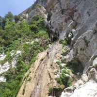
Nach dem letzten Becken links über den kleine Felsrücken zum Ausstieg der Cordula Orbisi. Von der Stelle links über steilen, gut kletterbaren Felsen (Markierung Steinmännchen) hoch. Hier das nach kurzer Zeit erreichte Schotterfeld rechts, leicht ansteigend (Steinmännchen) bis zum offenen Bergrücken folgen. Dann weiter dem Bergrücken und dem nun immer sichtbarer werdenden Weg bergauf folgen. Nach ca 20min erreicht man die Schotterpiste die man vorbei an einem Brunnen/Tränke bis zum Ausgangspunkt/Parkplatz folgt.
After the last pool, turn left over the small rocky ridge to the exit of the Cordula Orbisi. From the point left up over steep, easily climbable rock (marked cairn). Here the gravel field reached after a short time, follow right, slightly ascending (cairn) to the open ridge. Then continue to follow the ridge and the now increasingly visible path uphill. After about 20min you reach the gravel road that you follow past a fountain / watering hole to the starting point / parking lot.
Coordinate:
Parcheggio all'entrata
Oberer Parkplatz ggf. 4 x 4
Inizio del canyon
Parcheggio Entrata e uscita
Parkplatz bei Informationsschild
Fine del canyon
Letteratura:
Mappa
Mappa
1:25000
Libro Canyoning
Corrado Conca
2009
Libro Canyoning
Franck Jourdan / Jean-François Fiorina
2009
Libro Canyoning
Stéphane Coté / Caracal et les Sancho Panza
2009
Libro Canyoning
Corrado Conca / Paolo Madonia / Diego Leonardi
2002
Info sul canyon ACA
Info sul canyon Cwiki
Info sul canyon Descente
Info sul canyon Descente
Info sul canyon Ropewiki
Altro info sul canyon
Altro info sul canyon
Altro info sul canyon
Info sul canyon Ropewiki
31.03.2025
Jeanne
⭐
★★★★★
📖
★★★
⚓
★★★
💧
Normale
Completato ✔
nessuna traduzione disponibile
Automatisch importiert von Descente-Canyon.com für Canyon Donini
(Quelle: https://www.descente-canyon.com/canyoning/canyon-debit/21721/observations.html)
28.03.2025
odo38BaboulDawaniSaut Mont
⭐
★★★★★
📖
★★★
⚓
★★★
💧
Normale
Completato ✔
nessuna traduzione disponibile
Automatisch importiert von Descente-Canyon.com für Canyon Donini
Ras
(Quelle: https://www.descente-canyon.com/canyoning/canyon-debit/21721/observations.html)
20.03.2025
jimmy347An_a
⭐
★★★★★
📖
★★★
⚓
★★★
💧
Normale
Completato ✔
nessuna traduzione disponibile
Automatisch importiert von Descente-Canyon.com für Canyon Donini
Magnifique canyon !Amarrages OK.Attention aux cairns : il y en a partout sur tous les GR, ne pas s’y fier.
(Quelle: https://www.descente-canyon.com/canyoning/canyon-debit/21721/observations.html)
20.03.2025
jimmy347
⭐
★★★★★
📖
★★★
⚓
★★★
💧
Normale
Completato ✔
nessuna traduzione disponibile
Automatisch importiert von Descente-Canyon.com für Canyon Donini
DC, amarrages RAS, l'eau est bien fraîche mais rien d'insurmontable.
(Quelle: https://www.descente-canyon.com/canyoning/canyon-debit/21721/observations.html)
25.12.2024
Felix
⭐
★★★★★
📖
★★★
⚓
★★★
💧
Normale
Completato ✔
traduzione alternativa
➜
Lingua originale
Zufahrt frei kein Schild dass Straße gesperrt gefunden
Sehr Schöner hölencanyon der im Vergleich zur Außentemperatur relativ warm war
Rückweg gut zu finden dank den vielen Steinmänchen
Access free no signs found that road closed
Very nice wooden canyon which was relatively warm compared to the outside temperature
Easy to find the way back thanks to the many cairns
25.12.2024
Felix
⭐
★★★★★
📖
★★★
⚓
★★★
💧
Normale
Completato ✔
traduzione alternativa
➜
Lingua originale
Kein Schild gefunden dass Straße gesperrt ist
Höhle schön warm im Vergleich zur Außentemperatur
Rückweg Super Markiert mit Steinmänchen
No signs found that road is closed
Cave nice and warm compared to the outside temperature
Way back superiore marked with little stones
22.10.2024
Franz Baumgartner
⭐
★★★★★
📖
★★★
⚓
★★★
💧
Basso
Completato ✔
nessuna traduzione disponibile
Automatisch importiert von Descente-Canyon.com für Canyon Donini
Last pool and anchorages ok.
(Quelle: https://www.descente-canyon.com/canyoning/canyon-debit/21721/observations.html)
08.07.2024
excalibure
⭐
★★★★★
📖
★★★
⚓
★★★
💧
Basso
Completato ✔
nessuna traduzione disponibile
Automatisch importiert von Descente-Canyon.com für Canyon Donini
Très beau - Fait à 2 en 5h, avec l'option rappel jusqu'en bas. Retour 1h30 (30 mn de descente pour rejoindre le bas de la vallée, puis montée en traversée sur la droite pour rejoindre le GR qui mène à la voiture - eau glaciale, mais retour très chaud il faisait 40° - bivouac possible à proximité). A noter plusieurs petits rappels non mentionnés dans les topos.
(Quelle: https://www.descente-canyon.com/canyoning/canyon-debit/21721/observations.html)
31.05.2024
Paskal rider
⭐
★★★★★
📖
★★★
⚓
★★★
💧
Basso
Completato ✔
nessuna traduzione disponibile
Automatisch importiert von Descente-Canyon.com für Canyon Donini
Je pense que c’est le truc majeur de la Sardaigne , tout est juste ultime, on aurait jamais cru qu’il y ai autant d’eau sur une île aussi sèche .Bref à faire sans hésitation.Tout est ok niveau équipement , pensez au frontale et attention au retour , suivez bien le GR 502.
(Quelle: https://www.descente-canyon.com/canyoning/canyon-debit/21721/observations.html)
28.05.2024
Andreas Gremmel
⭐
★★★★★
📖
★★★
⚓
★★★
💧
Basso
Completato ✔
traduzione alternativa
➜
Lingua originale
Einstieg leicht zu finden - steinmännchen markiert
Orientierung in höhle leicht
Anker gut!
Traumhaft schöner höhlencanyon
Entry easy to find - cairn marked
Easy orientation in the cave
Anchor well!
Fantastically beautiful cave canyon
15.05.2024
Corsac
⭐
★★★★★
📖
★★★
⚓
★★★
💧
Basso
Completato ✔
nessuna traduzione disponibile
Automatisch importiert von Descente-Canyon.com für Canyon Donini
Toujours aussi spectaculaire!!! :)Pour l'accès au trou, il faut être attentif à regarder la rive droite dans le lit de la rivière. Une plaquette + 2 anneaux marquent le début.La main courante a été changée (merci!) pour accéder à la première grande vasque. 2h15 dans le canyon/la grotte pour 4 personnes. 70m de corde suffise pour le dernier rappel si on le fait en 2 fois (il y a un ancrage au bout la vire pour faire un second rappel).Ca ne coule pas dans le dernier rappel. L'eau est froide dans la grotte. (gant néoprène recommandé)
(Quelle: https://www.descente-canyon.com/canyoning/canyon-debit/21721/observations.html)
10.05.2024
Clarissa Linder
⭐
★★★★★
📖
★★★
⚓
★★★
💧
Normale
Completato ✔
traduzione alternativa
➜
Lingua originale
Altri utenti sono stati: Peter Lampacher Maik Plank
Beeindruckender Höhlencanyon!
Stände und Fixseile in gutem Zustand.
Impressive cave canyon!
Stands and fixed ropes in good condition.
Altri utenti sono stati: Peter Lampacher Maik Plank
04.05.2024
ipatati
⭐
★★★★★
📖
★★★
⚓
★★★
💧
Secco
Completato ✔
nessuna traduzione disponibile
Automatisch importiert von Descente-Canyon.com für Canyon Donini
Ne coule pas mais les vasques sont pleines d'une eau claire et glaciale. Vraiment très beau
(Quelle: https://www.descente-canyon.com/canyoning/canyon-debit/21721/observations.html)
28.04.2024
Benmag
⭐
★★★★★
📖
★★★
⚓
★★★
💧
Basso
Completato ✔
nessuna traduzione disponibile
Automatisch importiert von Descente-Canyon.com für Canyon Donini
Pour trouver l'entrée du canyon :Une fois garé, descendre dans la continuité de la piste sur moins de 100m jusqu'à aboutir sur une "placette" : à gauche, derrière une barrière, la piste descendante qui sera empruntée en montant au retour . En face des rochers. À droite en hauteur un enclos . Monter à droite en laissant l'enclos à main gauche. Sur la crête, basculer dans le talweg. Le descendre en surveillant en rive droite l'entrée 3m en hauteur, matérialisée par une corde.PS : au pied du premier rappel, aller dans le sens contraire de la flèche, c'est-à-dire à droite en lisant l'inscription. Canyon d'exception.
(Quelle: https://www.descente-canyon.com/canyoning/canyon-debit/21721/observations.html)
27.04.2024
Giovannai
⭐
★★★★★
📖
★★★
⚓
★★★
💧
Basso
Completato ✔
nessuna traduzione disponibile
Automatisch importiert von Descente-Canyon.com für Canyon Donini
Super canyon en speleo, l’intérieur est magnifique , départ acces facile ( aller dans le lit de la rivière qui est à sec , faire 300m et bien regarder à droite , on observe une corde qui descend ) eau très froide !! Et on arrive sur la C50 avec une vue incroyable ! Pour le retour descendre 300metres une fois en bas de la C50 et monter dans le croisement entre les deux rivières à sec a gauche , suivre la première crête on retrouve un chemin balisé au bout de 200m de monter . Incontournable de Sardaigne
(Quelle: https://www.descente-canyon.com/canyoning/canyon-debit/21721/observations.html)
24.04.2024
6Squal
⭐
★★★★★
📖
★★★
⚓
★★★
💧
Basso
Completato ✔
nessuna traduzione disponibile
Automatisch importiert von Descente-Canyon.com für Canyon Donini
(Quelle: https://www.descente-canyon.com/canyoning/canyon-debit/21721/observations.html)
14.04.2024
onerupee
⭐
★★★★★
📖
★★★
⚓
★★★
💧
Basso
Completato ✔
nessuna traduzione disponibile
Automatisch importiert von Descente-Canyon.com für Canyon Donini
Parcouru ce jour, pas trop d'eau cet hiver aux dires des locaux, donc ça coule a peine a la sortie. Pour ma part une belle traversée spéléo qui ce termine par une c50, seule partie canyon. Un incontournable de Sardaigne.
(Quelle: https://www.descente-canyon.com/canyoning/canyon-debit/21721/observations.html)
31.10.2023
Amaury
⭐
★★★★★
📖
★★★
⚓
★★★
💧
Secco
Completato ✔
nessuna traduzione disponibile
Automatisch importiert von Descente-Canyon.com für Canyon Donini
Magnifique canyon sous terrain ! Les 2 premiers rappels sont en ambiance spéléo mais après ça s'élargit. Bel enchaînement de marche, nage, rappel et toboggans dans un eau claire et froide. Ras sur l'équipement.Pour trouver l'entrée en RD, il y a un cairn à l'opposé sur la RG
(Quelle: https://www.descente-canyon.com/canyoning/canyon-debit/21721/observations.html)
02.05.2023
System User
⭐
★★★★★
📖
★★★
⚓
★★★
nessuna traduzione disponibile
Der aktuelle Canyon wurde teilautomatisiert mit Canyon https://canyon.carto.net/cwiki/bin/view/Canyons/GrottaLuigiDoniniCanyon.html zusammengeführt.
09.03.2023
System User
⭐
★★★★★
📖
★★★
⚓
★★★
nessuna traduzione disponibile
Daten importiert von https://canyon.carto.net/cwiki/bin/view/Canyons/GrottaLuigiDoniniCanyon.html
09.03.2023
System User
⭐
★★★★★
📖
★★★
⚓
★★★
nessuna traduzione disponibile
Info: Teile der Canyonbeschreibung wurden automatisiert übernommen. Konkret die Felder Weblinks, Koordinaten, Rating, Länge des Canyon, Einfachseil Mindestens von https://www.descente-canyon.com/canyoning/canyon/21721
09.03.2023
System User
⭐
★★★★★
📖
★★★
⚓
★★★
nessuna traduzione disponibile
Daten importiert von https://www.canyoning.or.at/index.php/liste-aller-canyons/442-grotta-donini
30.03.2022
Christian Balla
⭐
★★★★★
📖
★★★
⚓
★★★
💧
Normale
Completato ✔
traduzione alternativa
➜
Lingua originale
Sehr schöne Tour. Fotos, Videos, GPS Daten unserer Tour siehe
https://www.christian-balla.de/Donini
Very nice tour. Photos, videos, GPS data of our tour see
https://www.christian-balla.de/Donini
Nuovo rapporto
Riportare brevemente e concisamente le informazioni più importanti dell'ultimo tour o importanti informazioni attuali sul canyon. Se necessario con link a video, foto, ecc..
*
*
*
Esc
Del
Idrologia:
